Kuril Lake. Salmon goes to spawn


Kuril Lake
The lake is located in the eastern part of the Pauzhetskaya Depression and occupies a deep caldera basin formed by the additional subsidence of part of the bottom of this depression. It is caused by the devastation of the magma chamber due to eruptions of the adjacent Ilyinsky and Diky Ridge volcanoes. With an absolute height of the lake of 104 m and a depth of over 300 m, its bottom is 200 m below sea level. No lake in Kamchatka has such a feature. The maximum dimensions of the lake are 9x11 km. It is the third largest among all lakes in Kamchatka and the second among freshwater lakes, second only to Kronotsky. In addition, it ranks 7th in depth among all reservoirs of the Eurasian continent.
Archaeological excavations have established that human settlements in Kamchatka (Ushkovskoye Lake) existed at least 15 thousand years ago. They were probably in the south of the peninsula and in the area of the modern Ozernaya River. When catastrophic eruptions began here, the residents fled to safe places, but information about this was preserved in the memory of posterity and reached Krasheninnikov’s time in the form of a legend that he wrote down. Here is a brief summary of its contents: “Once upon a time, on the site of a lake, a high mountain rose, so high that it blocked the sun for the neighboring mountains, thereby causing their indignation and frequent disputes. Finally, they became so tired that the high mountain rose and went into the sea, and left its heart in its native place, and in the wake of the mountain a river flowed into the sea.”
The southernmost island, indeed, resembles a heart in its shape. In Krasheninnikov’s time it was called the Heart-Stone, and now the Heart of Alaid. Alaid was the name of the volcano and the northernmost island of the Kuril ridge. The island was subsequently renamed Atlasov Island, but the volcano retained its name.
During the formation of the caldera, masses of viscous magma were squeezed out from its bottom. The Heart Alaid Islands, two Chayachy Islands and the Samang Archipelago, consisting of four islands, emerged. The inaccessible islands of Heart Alaid and Chayachy are convenient places for seagulls to hatch their chicks. But there is not enough food in the lake for the large colony. And in the mornings you can watch flocks of them flying along the Ozernaya valley to the Sea of Okhotsk - 40 km away to feed. There, on the seashore near the fish processing plant, they fill themselves to capacity with waste from cutting fish and return the same way to the lake. They feed their hungry chicks by regurgitating semi-digested food into their open mouths.
On the eastern shore of the lake, in Vostochnaya Teplaya Bay, at the foot of the lava slope of the Ilyinsky volcano, the Kuril thermal springs are located. Here, weak streams of water with a temperature of 35-37o emerge from the cracks of the lava flow.
Kuril Lake is a unique natural site, as its surroundings are home to the largest population of brown bears in the world. Currently, the total population size is about 1000 individuals. The unique ecosystem that has developed on Kuril Lake arose and continues to this day in connection with the reproduction of one of the largest stocks of valuable Pacific salmon - sockeye salmon. Every year, from 3 to 10 million sockeye salmon come to Kuril Lake to spawn. Such an abundance of fish attracts many predators to its shores, including brown bears.
Kuril Lake is considered the largest spawning ground for sockeye salmon in Eurasia. The population size of this fish can reach 6 million individuals. Spawning lasts a long time - from May to October.
Spawning is important for the ecosystem of this region and the entire peninsula. The registration of incoming fish and monitoring of offspring is carried out by the TINRO observation station. It is located on the west coast and has been operating for a long time.
As soon as the fry hatch from the eggs, they live in the lake for some time and then go into the waters of the Pacific Ocean. Years later, they return to the spawning ground to hatch new offspring.
You need to know that sockeye salmon looks different in fresh water and in salt water. The color of the fish during the mating season changes to bright red instead of silver. At this time, males even grow jaws similar to a bird’s beak.
If you believe approximate calculations, then in 1 year up to 10 million fish rise to the Kuril Lake, in rare years the figure reaches 20 million. These are big numbers, indicating the largest sockeye salmon migrations in all of Asia.
At the moment, a large number of fishing enterprises are located along the banks of the river. Ozernoy and along the coast of the Sea of Okhotsk. Technology has developed so much that if you want, you can catch all the fish. Of course, in order to maintain the natural balance in the ecosystem, enterprises adhere to regulations. There are certain days when fish pass without obstacles, and there are days for fishing. This approach has allowed the sockeye salmon population to recover in recent decades.
It takes sockeye salmon about 4 days to reach their destination and lay eggs. The fish moves along the Ozernaya River unevenly and often lingers in depressions along the way. The peak of migration occurs from mid-July to early September.
Of course, in addition to sockeye salmon, there are other types of fish here: chum salmon, pink salmon, chinook salmon, and char.
In addition to large migrations of fish, tourists are attracted here by bears who don’t mind going “fishing”. According to rough estimates, by August about 250 brown bears come to the shore of the lake. They are under the protection of the reserve. Bears feed on fatty salmon and catch river otters and foxes. Browns simply love fishing!
Protection from the reserve workers and the abundance of food affect the behavior of brown bears. They relax more and play with each other. Therefore, photographers from all over the world often come here to take beautiful photos of dancing and kind bears. Such photographs participate in competitions and win prizes.
It’s also impossible to live without birds on Kuril Lake. The largest colony of slaty gulls lives here. In total more than 1500 pairs. In winter, large predators also come here to hunt: golden eagles, white-tailed eagles, and Steller's sea eagles. Their greatest concentration is observed in the area between the Etamanka and Khakytsyn rivers, on the Ozernaya River.
About 2,000 wild ducks and hundreds of whooper swans spend almost the entire winter on the water. The diet of birds necessarily includes sockeye salmon and its caviar. There are no vegetarians here.
Kuril Lake is visited by birds from the passerine family, mainly during autumn migrations. This is explained by the fact that Kuril Lake is the optimal place to relax before leaving the Kamchatka Peninsula. There are simply no more southern places with good parking conditions.
While you, friends, were fast asleep, and the legislators of the most democratic country in the world were considering the next round of sanctions against Russia, we collected duffles and indulged in dreams of looking at the famous brown bears at least from afar. So early in the morning, when Roman arrived at the house, everything was already ready - a tent, sleeping bags and two huge trunks with the necessary things. And, although we are flying today not somewhere to the potentially inhabited Proxima Centauri, distant parsecs away, but to the South Kamchatka Nature Reserve, nevertheless, the strategic supply of products is neatly packed - cervelat, cheese and sweets.
The South Kamchatka Nature Reserve is known as a protected corner of the peninsula, a difficult-to-reach place with no settlements. Complete desertion, except for a handful of scientists and a few inspectors throughout its gigantic territory of 322 thousand hectares. But it is there that the largest population of the main Kamchatka animal lives.

We plan to spend several days in this protected natural area. And we still don’t know that our dream will soon come true: in less than half a day, on the shores of the Kuril Lake, literally a few steps away, we will see bears hungry for red fish, and water literally boiling from salmon going to spawn...

Direction – South Kamchatka Nature Reserve
Ready to fly? The propeller blades forcefully capture the air currents... The car shuddered and took off from the ground. From the places of civilization to the bear kingdom, where there is pristine nature and traces of unprecedented animals, we fly for an hour and a half. The helicopter is huge, with excellent visibility from its operating height, and you can also open the windows.
It is not surprising that almost all of the tourist people are busy taking pictures. Katya and I are wrapping ourselves in sweaters: the neighboring window of the helicopter is also wide open - Sanya is filming the landscapes. Forests and tundra, all imaginable shades of green, blue rivers and sky, blue-violet mountain peaks in white patches of snowfields.

Roman, our Kamchatka friend, is a thorough person. Before traveling to the reserve, he considered it his duty to first take us to the small Museum of Nature in the city of Elizovo. There, in a cramped exhibition hall filled with all sorts of stands, exhibits, sculptures and stuffed animals, a scientific base was laid out for the upcoming trip, and we were imbued with the consciousness that we were heading to an exceptional and interesting place.

Where is the reserve and Kuril Lake located?
Included as a subdivision of the Kronotsky Biosphere Reserve, the State Nature Reserve of federal significance "South Kamchatka" occupies a large area at the southernmost tip of the peninsula, where it is washed by the waters of the Pacific Ocean and the Sea of Okhotsk. Its functions include environmental protection activities, systematic study of coastal, terrestrial and lake ecosystems and the development of natural-educational tourism.
South Kamchatka Nature Reserve and Kuril Lake on the map of Kamchatka:

Kuril Lake and its origin
More than eight thousand years ago, an environmental disaster on a global scale broke out in the south of Kamchatka. The history of mankind knows many cataclysms associated with fire-breathing mountains, but no one could tell about the horror that happened then. There are no witnesses left. Only in the ancient legends of the Itelmens can one guess the echoes of those events...
As you know, the Kamchatka Peninsula is part of the so-called Pacific Ring of Fire, which includes 75% of all active volcanoes on the planet. However, the coexistence of people and fire-spewing mountains in this seismically active region is considered more or less peaceful.
And then the incredibly powerful activity of the awakened volcano began. “From the depths of an erupted impulse - Tragic and proud - the whirlwinds of ancient forces shot up”…
First there was a terrible roar, which would continue to thunder incessantly for many days. Then huge columns of fire with smoke, ash and debris rose into the Earth's atmosphere.
Rivers of molten lava flowed, erupting in endless streams from the depths of the earth. Soon, unstoppable, they reached both shores of Kamchatka and began to flow into the waters of the Pacific Ocean, as well as the Sea of Okhotsk.

When, finally, the magma chamber was devastated, the surrounding area of 6 thousand square kilometers was covered with a thick layer of powerful emissions of ash, pumice and other substances. There was nothing living around. Everyone died - people, animals, plants. And then the roof of the crater collapsed and a gigantic failure of the earth’s crust formed - 12.5 km long, 8 km wide and more than 300 meters deep.
Well, then long-term geological processes slowly flowed, taking centuries. Then rains, melting glaciers and springs that made their way to the top began to gradually fill the bowl of the huge caldera, slowly transforming it into what is now the most visited and picturesque object of the South Kamchatka Nature Reserve and is called Kuril Lake.
Kuril Lake against the backdrop of other Kamchatka lakes
How many lakes are hidden in the mountains and valleys of Kamchatka? A lot of? Not just a lot, but a great multitude: their number reaches about one hundred thousand. But here’s what’s interesting: the entire space they occupy does not exceed two percent of the total area of the region.

Among the astronomical number of lakes in Kamchatka, Kuril Lake stands out as a star of the first magnitude. In terms of its size, it occupies an honorable third place among others, and if we take into account exclusively freshwater bodies of water, then among these it will be the second in terms of mirror area.
The five largest lakes in Kamchatka:
| Name | Location | Square (in sq. km) |
| Nerpichye (including the bay called Lake Kultuchny) (salty) |
Northeast of the peninsula estuarine part of the Kamchatka River average depth – 3.4 m, maximum – 12 m |
552 |
| Kronotskoe (freshwater) |
Eastern part of the peninsula Kronotsky Reserve average depth – 51 m, maximum – 148 m |
242 |
| Kuril (freshwater) |
South of the peninsula average depth -195 m, maximum – 316 m |
77 |
| Azhabachye (freshwater) |
Ust-Kamchatsky district average depth – 17.05 m, maximum – 33 m |
63,9 |
| Palanskoe (freshwater) |
Foothills of the Sredinny Range, Tigilsky district average depth – 14.8 m, |
28,2 |
One of a kind
Kuril Lake is a body of water unique in many respects:
- To begin with, it is so deep, only Baikal and Lake Teletskoye in Altai surpass it. Not a lake, but a real Maracot abyss!
- The soil under its water - pay attention! – located 200 meters below ocean level. Check for yourself, taking into account the maximum lake depth and the position of the mirror, corresponding to 104 meters above the sea surface.
And given the fact that the marine waters of the South Kamchatka Nature Reserve are shallow - their depth is within fifty meters, then its very bottom is located below the bottom of the world ocean. - Despite the fact that in the eastern part there are hot springs, the temperature of the lake water is even in summer! – does not exceed 10 degrees.
- In winter, strong winds blow through the territory of the reserve; frosts often reach twenty degrees. However, the reservoir does not freeze every year. This happens about once every ten years. And even then, at the mouths of the flowing streams - the Khakytsin and Etamynk rivers - polynyas remain, and the blue vein of the flowing Ozernaya River is only partially covered with ice - in the lower reaches.
And that’s not all there is to tell interesting things about Kuril Lake...
Cordon "Ozerny" in the South Kamchatka Nature Reserve
...The Blue River meanders between the low banks, making frequent loops in the thickets of yellow-green alder dwarf trees and between the astrakhan pimples of the copses. The light blue bowl of Kuril Lake, one of the largest in Kamchatka, unfolds below us. Finally, the helicopter, swaying in a peculiar way, descends and lands at the Ozerny cordon.

According to the definition in the encyclopedia, a guard post in a nature reserve is called a cordon. Here it represents an area on the shore of about one hundred by one hundred meters. Two rows of thin wire under a small current are stretched along its perimeter. This is for protection against bears.
Inside there are helipads, boats, a few equipment, and information stands. And the main thing is several wooden buildings, as well as tents - a motley cluster of small and large Canadian ones.

No, we didn’t live in that one, but in one of the smaller ones. There are also laid paths connecting all the elements. A cheerful and loud-voiced bunch of children aged from 7 to 15 years jump along the paths, like molecules in continuous Brownian motion.
It turns out that our arrival coincided with the arrival of a new shift of a children's environmental camp created for schoolchildren from the so-called Ozernovsky bush - fishing villages bordering the South Kamchatka federal reserve. The younger generation comes here to relax, but one of the basic rules of the eco-camp is only active recreation!
Children draw, make reports, take photographs and shoot videos. They go on hikes and learn to live in harmony with nature. They get acquainted with the work of government inspectors and volunteers, and together with scientists they conduct observations of bears, sockeye salmon going to spawn, insects and birds.

Boat trip on Kuril Lake
We have a tight schedule - there is so much to see in three days! We quickly set up a tent and throw things into it. First of all, we rush to the boat pier, from where boats with tourists go for a walk along Kuril Lake.
We noticed: for some reason the floating pier is especially loved by big and small bears. But somehow the young bears especially like to sit and dream near the romantic white mooring structure.

Do you think maybe she is waiting for someone under the scarlet sails?
Meanwhile, we board the boat, each receiving a cheerful orange-colored vest, only the nose sticks out from the bulky flotation device.

Flooded with sunlight and surrounded by steep and green shores, Kuril Lake attracts with its grandeur and blueness. The panorama is completed by the mountains that turn blue on the horizon. We are in the middle of the lake, the boat is slowing down. All cameras are aimed at the correct cone of Ilyinskaya Sopka.
It is an active volcano that last erupted at the beginning of the 20th century. Then its lava flows once again changed the contours of the lake’s shoreline. Somewhere there, among the impassable piles of volcanic blocks, hidden from us by thickets of cedar and birch woodlands, hot springs gush out and jets of steam escape.
In addition to Ilyinsky, Kamchatka’s most beautiful reservoir is protected by other active volcanoes - Dikiy Greben, Kambalny, Kosheleva.
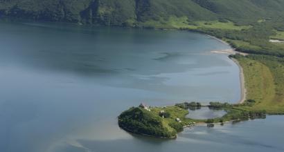
On the Kuril Lake there are several picturesque islands - products of lava that rose from the bottom of the flooded caldera - the Samang, Nizkiy, Chayachy archipelago and the diamond-cut Heart of Alaid. Interesting name, isn't it? It turns out that an ancient Itelmen legend is connected with him...
Legend of the Heart of Alaid
By the time of that catastrophic eruption, which became the first stage in the formation of the Kuril Lake, the near and distant surroundings of the future reservoir had long been inhabited by the Itelmens. Therefore, information about this extraordinary event, refracted in a unique way, was preserved in people's memory even after many generations. And now, in the lilac haze, the outlines of the famous island appear before us. And we listen to the legend...
Once upon a time, a troubled tribe of volcanoes lived here. All of them are hot, proud, irritable and envious. Every now and then quarrels and fights broke out between them, only fire and ashes flew into the sky.
And there was one among them who was not like the others. The giant Alaid is beautiful, kind and fair. The real black sheep of the tribe. In addition, Xu, the best of the girls, fell in love with him. This also did not add to our hero’s sympathy among his fellow tribesmen; you remember that they burned with black envy of any other person’s success.
And one day all this vile Caudla attacked the noble Alaid en masse. The roar of the showdown and the noise from the riot of the titan clan spread across the entire earth, and the sun was obscured by an impenetrable veil of dust and smoke. The details of how the fight developed are unknown, but the giant Alaid was unbearably offended after what happened.
So much so that he decided to leave both his tribe and the places dear to him forever. Leaving his homeland forever, he tore his loving heart out of his chest and left it lying in the center of the blue bowl of Kuril Lake.

The path along which Alaid left turned into the Ozernaya riverbed. The unfortunate girl, shedding bitter tears, turned into the Xu River. The volcano tribesmen, who did not expect such a turn of events, slowed down their fervor and hid in thought, and the stone giant himself still stands in the Sea of Okhotsk. After all, if you believe the legend, it is the very white cone of Alaid that rises on Atlasov Island...
Come on, seagull, answer me
Whether Alaid Island, Nizkiy or Chayachy Islands on Kuril Lake, each is an undivided patrimony of birds. For some unknown reason, they avoid settling only on the Samang archipelago. All high points on rocky patches of land are chosen by slaty-backed gulls, where their families raise their chicks in massive nests made of dry grass.
White, with dark gray feathers on the wings and back, a massive yellow beak, the tip of which nature slightly smeared red, and pinkish legs. We saw a lot of these noisy birds on . Seagulls are an indispensable element of the sea horizon, whose cries are inseparable from the coast, the wind and the rustle of the waves.

I can already hear the question: how did it happen that the inhabitants of the sea coast, living along the perimeter of Kamchatka, suddenly settled in such a distance - almost 60 km! - from salt water, and even in the freshwater Kuril Lake? There is no answer - so far much in the behavior of these birds remains unknown to scientists. That is why ornithologists on Kuril Lake keep a close watch on them.
In the meantime, experts on the kingdom of birds from the South Kamchatka Nature Reserve confirm that:
- firstly, the very fact of slaty-backed gulls living in a freshwater body is very unusual,
- secondly, the behavior of local birds is noticeably different from the habits of their sea comrades.
The peaceful life of gull colonies on the islands is interrupted from time to time by the invasion of uninvited brown gourmets. Kamchatka bears deftly climb slopes slippery from bird droppings to get to clutches of eggs or chicks that have not yet fledged. Four kilometers from the shore to the Heart of Alaid, predatory bears swim playfully.
For the slaty gulls themselves, regardless of their habitat, the main dish in their diet is fresh fish, although they do not at all disdain to dine on scraps from someone else’s meal or rummage through city garbage dumps with interest and benefit. But on Kuril Lake, seagulls, after bears, are the main consumers of sockeye salmon that come here to spawn.
Salmon in the splendor of crimson
Here it is... Transparent blue waves run from the boat to a narrow strip of beach. The water in the shallows is really blue, but near the shore it already takes on a red tint - this is given by salmon changing their color during spawning. The fish mass, which has not yet reached a critical size, presses against the shores...
Employees of the Kamchatka Research Institute of Fisheries, who have been conducting observations in the South Kamchatka Nature Reserve since the middle of the last century, made an interesting discovery. It turns out that the lake is filled with emissaries of the salmon genus along the shores clockwise, starting from Ozernaya.
A little time will pass, the peak of the spawning run will begin, and large accumulations of silvery fish bodies will suddenly acquire the whole gamut of red, coral, and burgundy tones. The gaze tries to penetrate into the frozen depths of the Kuril Lake; it is clear that thousands of dark silhouettes are rushing about there. This year's salmon spawning was slightly delayed due to cold weather; we arrived at the very beginning.
There are a huge number - about 33 thousand - species of fish in the world. But it’s good if a tenth of this diversity is of economic interest to humanity.

Salmon is the common name for one (albeit very large) family of marine commercial fish. Some of the members of this family live in the Pacific Ocean. Pink salmon, sockeye salmon, chinook salmon, chum salmon, coho salmon, masu salmon - their names sound like a wonderful song. Like all salmon, they go to fresh waters to spawn at the right time, where immediately after spawning the adults die, and the juveniles while away the initial period of their lives.
Along the shores of the Kuril Lake, into numerous rivers and streams, the instinct of procreation drives char, stickleback, chinook salmon, coho salmon, pink salmon, and chum salmon, but the first fiddle here is undoubtedly played by gigantic herds of sockeye salmon.

Red fish at a red price
Red fish attracts food lovers – brown bears – to the shores of Kuril Lake. Clubfoot fishermen manage to eat plenty of sockeye salmon.
What about people? Natural Kamchadals first tried bread only at the beginning of the 19th century; from time immemorial, their main food was “salmon fish of the family.” You yourself know how things stand with salmon and why this is so. I will say one thing - the Kamchatka Territory still has fish stocks that are unique in diversity and size.
In the meantime, in hopes of a better future and to remind you, here is an excerpt from an interesting book:
Salmon (red fish) is an amazing fish: the worse the meat, the better the caviar. The most common and simplest is chum salmon, but it is chum salmon caviar that is the most delicious and largest. The best salmon is Mezen salmon, from which salmon is made (the last time I saw it was at the buffet of the CPSU Central Committee in 1979, where I was for the first and last time), but I don’t remember eating salmon caviar. It should be added here that caviar taken from salmon in the sea is much worse than mature river caviar and requires more salt consumption. And now I will try to rank the salmon, from worst to best: chum salmon - catfish - pink salmon - char - masu - chinook salmon - salmon (not just salmon) Arkhangelsk and Mezen.
- Alexander Levintov “Great”
I’ll add on my own behalf - the place of sockeye salmon from the population of the South Kamchatka Nature Reserve is next to the Chinook salmon - the queen of salmon in terms of taste. As for such a variety of salmon as coho salmon, it is simply an excellent sea fish, but so far underestimated by our population. Here's proof for you - brown bears!
They really know a lot about red fish! For example, during salmon spawning, clubfoot prefer to catch Kamchatka sockeye salmon and coho salmon, but neglect chum salmon.

You, me, you and me,
You, me, you and me,
It's great to have salmon in the world!
If sockeye salmon were not found here,
Trouble would immediately happen,
People in Kamchatka would have a bad life.
***
We need to strive for balance
And everyone will make friends with nature,
So that there is harmony on earth!
The guys made a great song.
Salmon goes to spawn
We return to the pier, and from there to the cordon. Of course, under the protection of an armed ranger. Outside the perimeter - nowhere without a man with a gun, even on the bank that is two steps from the camp! The wire is stretched again, the current is turned on... We are relieved to get rid of the jackets that have immediately become unbearably hot, the sun is scorching with might and main.
Ozernaya originates near the cordon from Kuril Lake. It, the largest river of the South Kamchatka Nature Reserve, winds its way for fifty kilometers and flows into the cold expanse of the Sea of Okhotsk. Along it, like a gutter, many millions of grown-up Pacific salmon fry glide, setting off from the safe spawning grounds to fatten up into the sea.

Along it, after a few years, adult fish return from the ocean in tight schools to spawn in their native places. Homing is the scientific name for this phenomenon, the true nature of which scientists have not yet figured out. But there is a hypothesis that its basic basis is, that is, the ability of salmon to remember the chemical composition of the water in the place of their birth.
We joined a group of tourists who were about to go to a nearby fenced area. There is the territory of a fish survey station, a stationary facility of the Kamchatka Institute of Fisheries and Oceanography, where ichthyologists study the ecosystem of the lake, observe the fry, count how many red fish have risen to spawn in the reservoir and its tributaries. For this purpose, the river is blocked from one bank to the other by a bridge-dam.

Is it possible to count this?
Kuril Lake is the largest spawning ground for sockeye salmon. Its surroundings have the highest density of brown bears in the world. The total number of toptygins is estimated at one thousand specimens. How did you count the bears freely roaming the open spaces? And just like, for example, the same elephants and hippos in Africa! When animals are counted using aircraft, everything is more or less clear. But how can you find out how many fish come here... Nevertheless, this figure is also known - about 5 million sockeye salmon.

Oh, friends, how I would like to tell you in all the details how pundits are counting these millions, whose dark silhouettes with still greenish heads are trying to penetrate Kuril Lake through the wooden barrier structure erected by science.
But alas, we were not allowed onto the observation bridge; the secret of calculating the fish population remained unsolved. I had to limit myself to photos nearby and, having sipped lightly, went home. We returned, and here they were...

The main characters are brown bears of Kamchatka
Of course, you can go to Africa to see, and, but we wanted to watch brown bears in Kamchatka. After all, Toptygin is not only a national symbol of Russia, but also a calling card of the peninsula. If there are 120 thousand clubfoot throughout the country, then 16 thousand of them are the Kamchatka population.
Until now, we have only seen bear tracks - in, tufts of fur on the trees near the trails. And now we are in real bear territory.

At arm's length
Amazing things are happening in the South Kamchatka Nature Reserve: a meter from a thin wire stood a mother bear with four small dark brown cubs...
This is truly a rare sight, because usually a mother bear has two, maximum three babies! All this is true, but not for the South Kamchatka Nature Reserve, where the abundance of food, good wintering conditions and the environmental status of the territory had such a beneficial effect.

They say that it is not uncommon for bears to adopt orphaned babies. But when we arrived, he was running here alone without his mother. So restless and unkempt. Pathetic...
But for some reason, none of the many furry mothers showed kindness to the poor fellow when he tried to snuggle up with their happy families from time to time.

When a family of bears walks past the cordon fence to meet their needs, tourists run out in a crowd, and the clicking of cameras begins. It happens that photographers behave strangely in search of a better angle, but sometimes bears almost give photographers a heart attack with their antics.
A crowd with cameras gathered behind the security wire. It was an exciting photo shoot. The clubfooted model was in quiet thought, concentrating on some of her problems. The photographic equipment chirped joyfully.
Suddenly the main subject of the shooting resolutely turned around and, showing displeasure, moved towards our crowd. People immediately recoiled, suspecting the beast with ten-centimeter sickle-shaped claws of bad intentions.

Our stampede was heroically stopped by the cordon inspector present. This time the brown bear did not receive a portion of the lyuli, but another time during a similar prank we saw how the inspector first shouted, then waved his arms menacingly, and then applied the maximum measure of influence on the dull owner of the peninsula, throwing a flare at him.
Procrastination! Well, what kind of protection is this... A weak click on a wet nose! And Sanya and Katya are in the forefront! To whom bears are a joy, but my heart skips a beat at the sight of them. If only they would go their own way... And they do - slowly, along the beach past the pier where we had just disembarked.

They are playing catch up... They are having fun and don’t care about the sapiens who click and trample on the grass. Sanya tries to stand even closer - there is no more than three meters between him and the object of his admiration. Katya stretches forward in fascination. Father's daughter! But I manage to catch her. She pouted her lips and was offended. But even if dissatisfied, she stands nearby! Now you can take out your phone, take a photo of the bear and send your family the image of the big brown guy.
The bear is a dangerous animal
He stood nearby on the shore, not noticing us. Meeeeedveeeed! Photos, photos, photos... So... Round, club-footed, good-natured and clean. It doesn't smell at all! Not a bit like the beast that helpfully draws memory after all the domestic zoos. Although animals from traveling menageries leave especially strong impressions.
In general, the Kamchatka bear made me want to pet it... However, the bear is very dangerous, of enormous strength, and, most importantly, an unpredictable predator. whose behavior is often subject to misinterpretation.

When people communicate, most of the information is transmitted verbally, that is, through speech, but communication is also accompanied by facial expressions, gestures, and changes in posture.
Animals, of course, cannot speak, but those who believe that their facial expressions are poor are mistaken. Just the opposite! With their trained eyes, scientists counted 13 facial movements on the chimpanzee’s face. The internal state of the horse is expressed by 17 positions of the eyes, nostrils and lips. Dogs can show 16 senses with their expressive facial expressions. Even cats have everything written unambiguously on their whiskered faces.
The thick skin of a bear's face is a poor assistant in facial mobility and expressiveness. The bear's ears, a true and unmistakable indicator of the mood of cats and dogs, are deeply hidden in thick fur.
What is on the mind of a brown animal with a calm face is difficult to understand and predict. Even very experienced people sometimes fail to do this. That’s why, when photographing bears, you can quite unexpectedly find yourself in such a mess that it doesn’t seem like much...
And to get closer to them is an incredible risk. A cheerful man, a zoo director by profession, once said: “If you have a mortal enemy, then give him a nice tame bear cub.”

For the night is dark and full of terrors
The helicopter flew away, the bears left, and life settled down. At the cordon there is a canteen where they are ready to feed tourists lunch and dinner for a thousand rubles. We were offered soup, buckwheat with cutlet and compote. Tasty! I feel like I'm back in a pioneer camp. The sausage remains in the bag unclaimed.
It’s hot... The sun’s rays are like from engineer Garin’s hyperboloid. The children are running around restlessly, Sanya is wandering somewhere, and Katya is sitting in the shade of the boat. After the excursion, they are immediately pulled ashore and moved outside the perimeter so that the bears do not play pranks. I sat down next to her on the grass, and somehow imperceptibly dozed off... In the evening, when the insidious sun calmly sets, my face glows and burns, because we have no protective cream. They didn’t take it from us; they considered it unnecessary along with light summer clothes.
Sanya arranged for us to take a boat ride on Kuril Lake again - already at sunset.

It’s always good and beautiful on the water, but the daytime and evening lake is heaven and earth, everything looks different and is perceived differently. The calm water is coldly silver, the shores are shrouded in black shadows, a continuous dark mystery, no traces of the joyful beauty of the day.

It’s getting dark, we go to the tent. And only then do I realize that behind the thin fabric there is a purely symbolic wire, and there... It seems that I was not the only one who understood this. In the morning, Katya admitted that she had been imagining bears creeping towards the tent all night.

The darkness at the cordon of the South Kamchatka Nature Reserve is full of various sounds that are incomprehensible to the townspeople. In addition, in the next tent someone was snoring very expressively and loudly. And Sanya poked his head outside several times to check the situation. I had about the same impressions as that unforgettable night when in a remote camp in Botswana there was a knock on the door.
Much noise about a cyclone
In the morning the bustle and running around began. And all because yesterday evening the sky was covered in puffy wisps of clouds and there was no sunset. The weather began to deteriorate. The rangers said there was a cyclone coming. Cyclones are common in Kamchatka. But, the main thing is that this is a time of non-flying weather for helicopters. Moreover, the time is protracted, when you can be stuck in place for a week or more.
And it’s already time for us to fly away - we’ve seen enough of the bears. Even Katya no longer rushes to everyone, except mothers with cubs.
The Israeli group is sitting on backpacks, we should be sent with them. But when, despite the heavy clouds, a helicopter hovered over the cordon like a small green dragonfly, two elite tourists appeared at the airfield out of nowhere. And then they all outplayed it.

The privileged bourgeoisie flew away, along with them a group of Israelis flew into the sky, and we are still sitting under the low clouds and waiting. The weather is getting worse and worse. Well, exactly - “The country is sad, mountainous, damp. The winds blow around it almost continuously.”
One of the rangers comes up and says that there will be no more flights today. We are setting up the tent. Before we even had time to catch our breath, a new messenger comes running: we can recover together with the children’s camp. On foot.
From Kuril Lake, children go on an adventure trek through the South Kamchatka Nature Reserve, visiting an interesting place - the Kutkhina Bati tract, after which they return home to the village. But the trick is that from Ozernovsky helicopters make regular flights to Petropavlovsk! Well, let's take advantage of the happy coincidence... Goodbye, bears!

Interesting article? Subscribe to blog updates and get even more information on RSS Email
Kurilskoye is a crater lake in the south of the Kamchatka Peninsula on the territory of the South Kamchatka Federal Nature Reserve. The reservoir is surrounded by rocky shores and impenetrable bushes. By and large, in size this giant can only be second to Kronotsky, giving him the palm. Of the freshwater lakes in Kamchatka, Kurilskoe is the second largest (area 12.5 x 8 km).
It seems that here life flows somehow differently, leisurely, calmly, enjoying every moment. It’s beautiful, like in a fairy tale, and this is because the territory of the reserve, where Kuril Lake is located, has been included in the UNESCO Natural Heritage List since 1996. These are not all the interesting facts - we will highlight many of them below, and we are sure that you will feel a sincere desire to see the marvelous land and its attractions with your own eyes!

Kuril Lake on the map
Kuril Lake is located in the southern part of the Kamchatka Peninsula, and it can be seen even without using a strong zoom. The coordinates on the map of Russia are as follows: 51°27′18″N, 157°5′54″E
It is difficult to get to the reserve on your own at such a distance from the regional center. There are two options for transport - a helicopter or all-terrain vehicles. Both types of casting have their pros and cons. The main criteria are price, comfort, travel time, as well as dependence on weather conditions. By using a helicopter, you save a lot of time and travel in comfort, but the price of such a trip is many times higher, plus the weather has a big influence. By using road transport you will benefit in price and will not depend so much on weather conditions, but travel time increases many times and comfort, frankly, is much less.

Kuril Lake is located on the territory of the South Kamchatka Federal Nature Reserve, which covers vast areas in the south of the peninsula, including several kilometers of coastal waters. Protection and regulations are the most stringent, since this is the only federal reserve in the Kamchatka region. Employees and volunteers working on the territory tirelessly monitor the conservation of the population of rare birds and animals, including bighorn sheep, sea otters, brown bears, anturas, sealed seals, bean goats, Steller's eagles and many others.
To reduce the anthropogenic load on the natural complex, tourist visits are limited by quotas allocated by the state. Our company receives permission to visit this territory almost a year in advance, and tours are clearly tied to specific dates within the reserve. At the moment, we form only two groups annually, but there are many more interested people.

Weather on the lake
Due to its large area, in some years in winter the reservoir is not covered with ice at all. Imagine that the average water temperature here is quite high. So, off the coast, in September the figure is 7.6 °C, and this, mind you, is not the maximum, which, in turn, is 10.8 °C!

The proximity of the Sea of Okhotsk has a great influence on the weather. This sea is not calm, and the wind often carries rain and fog into the reserve. The only thing that saves us is the volcanoes and mountains surrounding the lake, which, like guardians, take the entire blow upon themselves.
The weather here is changeable and unpredictable. For example, you can go from a camp on the border of the reserve to white waterfalls or a stone town in sunny weather, but during the journey you will find yourself in torrential rain throughout the entire route. And upon returning to the camp, they found out that everything was calm, and the sun was shining just as well.

Therefore, the most valuable advice is to plan thoroughly for Kamchatka! Additional warm clothes, waterproof high boots and a raincoat will not be superfluous. As local guides say: “no one has ever been found fried.”
Origin of the reservoir
The maximum depth of the lake is 316 meters, the water is fresh. Its basin is a volcanotectonic depression, which was formed due to the subsidence of the earth's crust 8300-8400 years ago due to a strong eruption.
The formed depression at 104 m above sea level, the caldera, was occupied by a lake fed by snow and rain. Several islands rising above the surface of the lake are formed by lava deposits. These are the dome-shaped islands of Chayachy, Nizkiy, Heart of Alaid and the Samang archipelago with a relative height of 200-300 meters.

Several rivers and small streams flow into the lake (Etamynk, Vychenkiya, Kirushutk, Khakytsin, etc.), and the Ozernaya River flows out of it, running west to the Sea of Okhotsk. It is along this river that millions of fish rise to lay eggs and give birth to new offspring. Accordingly, the lake is characterized as wastewater. 4 kilometers from the source are the Kukhtina Baths - pumice outcrops associated with an outbreak of acidic volcanism in the early Holocene. The thickness of pumice formations in the area of the Kuril reservoir exceeds 100-110 meters.

Neighbors of the reserve and its attractions
Kuril Lake itself is interesting for many reasons. In particular, they are also interesting “neighbors” for tourists. For example, on the northeastern shore is the famous Ilyinskaya Sopka volcano.
There is also a place here for capes, which help to achieve natural harmony. In the south, Tugumynk juts into the lake, and in the northwest - Pulomynk. Beauty worthy of the brush of the most talented artist. Needless to say, the reserve is always in demand among tourists.

And that's not all - when you arrive here, you will hear the singing of water, it's the rivers running
- Vychenkia
- Etamynk
- Kirushutk
- Khakytsin
The river with the euphonious name Ozernaya playfully flows straight into the arms of the Sea of Okhotsk to the west. It is also worth mentioning that on the shore of Teplaya Bay there are outlets of hot mineral waters. Thus, another argument is added in favor of choosing this direction.
On the border of the reserve, there is a small settlement of Pauzhetka, where groups of tourists making a car-pedestrian journey stop.
From here you can go along a difficult and long road to a unique phenomenon - White Falls. You can find them on one of the slopes of the Koshelevsky volcano.

Water from the melting of snow and glaciers on the slopes of the volcano flows through the earth's crust, dilutes the minerals it contains and carries it to the surface. Immediately, minerals settle and color numerous stream beds a ghostly white color. Already from a distance on the approach you can see rivers of milk. When you come closer and scoop up water, it turns out to be transparent. The effect of whiteness is created by the colored riverbed, which is constantly renewed by nature.
Initially, we also took tourists to the White Falls, but the difficult walking road and frequent precipitation in this corner of the reserve caused great disagreement among the group, and in the end we decided to close this part of the route. We hope that someday the feeling of discovery and searching for new places will prevail over the need for comfort, and we will again be able to observe these rivers of milk with you.

The next interesting attraction, one of our favorite places, is the stone town. This bizarre structure was built by the wind.
It is called a town for the similarity of stone sculptures to a once destroyed ancient settlement. Here you can wander through the streets and climb into crevices. This is a place of ancient and mysterious power that can be felt everywhere.

The path to Stone Town is also not easy. For about 3-4 hours you will have to climb along a dry stream bed, through dense bushes and along rocky areas, but when you reach the top, about 850 meters, you understand that all your efforts are not in vain. An indescribable panorama opens up: in the distance Kuril Lake glistens in the sun , the Ozernaya River meanders like a snake, and Pauzhetka “smoke” on the right.
I just want to sit on a pebble under the warm rays of the sun and silently look at the beauty.
Flora and fauna
Kuril Lake is the largest spawning ground for sockeye salmon, a fish of the Pacific salmon family, in Eurasia. The population size here varies between 1.5-6 million individuals. Spawning is very long: it lasts from May to October and determines some of the features of the lake ecosystem.
The spawning process is very important not only for the ecosphere of a given area, but also for the entire peninsula, which is why the special observation station TINRO is responsible for recording incoming salmon and for future offspring. It has been located on the west bank for a long time, fulfilling its mission.

After the new fry hatch from the eggs, they live in the reservoir for some time, and then go to feed in the waters of the Pacific Ocean. A few years later, driven by instinct, they return again.
The same sockeye salmon in the salty waters of the Pacific Ocean and here, in a fresh body of water, looks completely different. In addition to the fact that it stops looking for food, the color of the fish during the mating season changes from silver to bright red, and in males even the body structure is subject to change - jaws similar to a bird’s beak grow.
According to rough estimates, the number of fish that rise to the Kuril Lake per year is about 10 million, and in some years about 20. This is one of the largest migrations of sockeye salmon in Asia, second only to the migration of fish along the largest river of the peninsula - Kamchatka.

Today, many fishing enterprises operate along the coast of the Sea of Okhotsk and along the banks of the Ozernaya River outside the reserve. The fishing technology is at such a level that, if desired, you can catch all the passing fish. In order not to disturb the natural balance, the operating hours of enterprises are limited to so-called “passing” days, during which the fish rises to its target without hindrance. Thanks to a set of environmental measures, the sockeye salmon population has recovered in recent decades after ruthless fishing in the middle of the last century.
The movement of fish along the Ozernaya riverbed is not uniform. Along the way, it settles in various depressions. The average time required to travel from the ocean to the spawning site is 4 days. The peak of migration, the runic movement, occurs between mid-July and early September. It is at this time that we plan to visit this territory in organized groups as part of tours.

Sockeye salmon is not the only species of fish living here; other species include pink salmon, chinook salmon, chum salmon, and arctic char.
The reserve attracts tourists not only with the spectacle of water red with fish, but also with bears flocking to this rich feast.
As a rule, by August, about 200-250 Kamchatka brown bears, which are under the protection of the South Kamchatka Nature Reserve, come to the lake area. Along with river otters and foxes, they readily feed on hearty and fatty salmon. They definitely like fishing on Kuril Lake!

The abundance of bear food and the protection of the reserve by workers affects the habits of the bears. They have more time to play with each other and relax. It is this circumstance that attracts nature photographers from all over the world. You have probably already seen on the Internet photographs of dancing bears, sad ones against the backdrop of the Ilyinsky volcano, cubs fishing with a twig, and many others. Most photographs of bears participating in various photo competitions are taken in these places.
The islands in the middle of Kuril Lake are home to the largest colony of slaty gulls in fresh water bodies - more than 1.5 thousand pairs. In winter, species diversity on the lake increases. Large predators gather here: about 400-700 Steller's sea eagles, up to 100-150 white-tailed eagles, about 50 golden eagles. Their greatest concentration is observed at salmon spawning grounds in the interfluve of Khakytsyn and Etamynka and on the Ozernaya River.

Several hundred whooper swans and 1.5-2 thousand wild ducks spend the winter on open waters. Sockeye salmon and its caviar are, to one degree or another, included in the diet of all species of birds, including even vegetarian species, and small forest birds (nuthatch, puffy duck, lesser spotted woodpecker, etc.).

During autumn migrations, representatives of the passerine family also visit Kuril Lake. Their choice is explained extremely simply: Kuril Lake is the only suitable place to stop before leaving the Kamchatka Peninsula through Cape Lopatka. To the south there are simply no conditions for stopping passerines.
Origin from time immemorial
Time has stopped here - this is true, but still there is a story that is filled with various interesting events. So, earlier this place was chosen by the aborigines, and their largest fortress settlement was located on Cape Siyushk.
People lived here, loved, worked, and also came up with names for certain natural objects, and, by the way, most of them are closely intertwined with the legends recorded by Krasheninnikov during his campaigns:
Previously, in the place where the lake is now located, there was a majestic mountain, and it was so high that it blocked the sunlight from the neighboring mountains. Naturally, this caused violent indignation on the part of the neighbors. Quarrels began. As a result, the neighboring mountains and volcanoes became so boring that “Vysokaya Gora” could not stand it and... went straight into the Sea of Okhotsk. It was in her place that a lake appeared, which to this day holds her heart. The mountain, going into the sea, left a trail behind it, along which the Ozernaya River, already mentioned by us, ran after it.

A very interesting interpretation, isn’t it. It is also interesting that the local inhabitants (and the whole world) call the rocky island the Heart of Alaid; it is located directly in the south of the island, and is similar in shape to a heart. Krasheninnikov was able to very accurately describe many places that have survived to this day.
One of the brightest and most memorable attractions of Kuril Lake is the active Ilyinsky volcano. It is located in the northeastern part of the lake. Its regular cone-shaped shape is striking, the top of which reaches 1578 m. Relatively young lava flows of Ilyinsky descend directly into the lake and form several bays.

At the foot of the volcano in Teplaya Bay there are thermal springs. They are named Kuril Islands in honor of the lake. Outlets of water with temperatures up to 45 o C are hidden between lava blocks overgrown with dwarf cedar and open forests of stone birch.
The western shore of the reservoir is bordered by the Wild Ridge ridge (1080 m). In calm weather, volcanoes are reflected on the surface of Kuril Lake. Landscapes appear before your eyes, from which it is difficult to take your eyes off. This is probably exactly what the Thirtieth Kingdom, the Thirtieth State, looks like.

Video from our trips to Kuril Lake.
We invite you to take an exciting trip to Kuril Lake and see everything with your own eyes.
We have professional guides who will show you all the secret and hidden corners of Kamchatka.
Send your good work in the knowledge base is simple. Use the form below
Students, graduate students, young scientists who use the knowledge base in their studies and work will be very grateful to you.
Posted on http://www.allbest.ru/
Introduction
3. Water resource protection
Conclusion
Introduction
Lake Kurilskoye is a natural monument, which is located in the area of the South Kamchatka Federal Reserve, and has been included in the UNESCO World Natural and Cultural Heritage List since 1996.
Kuril Lake occupies a large basin with a depth of about 300 m, the height above sea level is 103 m. It is the third largest among all lakes in Kamchatka and the second among freshwater lakes, second only to Kronotsky.
The picturesqueness of the lake, above which the Ilyinsky volcano rises on one side and the Wild Ridge on the other, is enhanced by rocky capes and several islands jutting into it.
At the source of the Ozernaya River from the lake there is an observation station called TINRO, which records the salmon that come here to spawn.
Several rivers flow into the lake. The sources of one of them go to the Kambalny volcano, the river washes out and brings a lot of pieces of pumice to the lake.
Teplaya Bay is located southwest of the Ilyinsky volcano. Its shore is dotted with outlets of mineral hot waters. They warm the water in the bay itself.
Kuril Lake is a nature reserve and at the same time a natural monument of a zoological nature.
1. Physiographical sketch
Lake Kurilskoye, one of the largest lakes on the Kamchatka Peninsula, is located at an altitude of 104 m above sea level in the south of the peninsula, 60 km from Cape Lopatka, 14 km from the Pacific coast and 32 km from the coast of the Sea of Okhotsk. Located in the river basin. Ozernoy and gives rise to this river. The morphological and hydrological characteristics of the lake were assessed and clarified repeatedly throughout the entire period of its research (Derzhavin 1916, Krokhin, Krogius 1937, Ponomarev and others). According to the latest version (Nikolaev, Nikolaeva, 1991), the lake. Kurilskoe has the following characteristics: area - 77.05 square meters. km, volume - 15,042 cubic meters. km, maximum depth - 316.0 m, average depth - 195.2 m, catchment area - 392.0 sq. km, the period of complete water change in the catchment is 18 years, the littoral area (depth 0-5 m) is 1.0%, the average transparency in summer is 10.0 m. Powered by snow and rain.
Phytoplankton of the lake Kurilsky has been studied for many years (Vorokhnin, 1937, Nosova, 1968, Lepskaya, 1988, 2002). According to the latest published data (Lepskaya et al., 2003) on the composition of phytoplankton in the deep-water part of the lake, 59 species and intraspecific taxa have been identified.
Lake Kurilskoe is a crater. Born from a powerful volcanic explosion, filled with snow and rain water, framed by volcanoes. Once upon a time, lava flows of the Ilyinsky stratovolcano flowed directly into the lake, creating picturesque bays. Mountains approach the lake closely from almost all sides: from the west, the lava-extrusive massif Dikiy Greben, over 1000 m high, approaches the lake itself; from the north-west and north - the spurs of the Golyginskaya peak, from the north-east lava flows of the andesite-basalt volcano Ilyinskaya Sopka (1576 m) descend to the lake; from the east and southeast, the lake basin is surrounded by low-mountain relief formed by volcanic-sedimentary rocks of different ages. In the south, the mountains retreat 5-6 km. Here, directly adjacent to the lake is a plain composed of river sediments that formed the most significant tributaries of Lake Kuril: the rivers Gavryushka, Kirushutk, Khakytsin and Etamynk. From the south, this plain is limited by the spurs of the Kambalnaya and Kosheleva hills].
The lake has a round shape, slightly elongated in the meridional direction, predominantly steep banks with a number of terraces and a slightly rugged coastline. The threshold, located at a depth of 150 m, divides the lake basin into two parts - northern and southern. The northern part, called the Northern Bay, reaches a depth of 200 m. The depression in the southern part has very steep stepped slopes, quickly descending to a depth of 300 m, and a flat bottom.
25 rivers and streams flow into the lake. Only one river, Ozernaya, flows through the trench on the western side of the lake. Evaporation makes the smallest contribution to the water balance of the lake. The lake belongs to reservoirs with slow water exchange; The time for complete water exchange is, on average, 17.4 years.
In the northeastern part of Lake Kurilskoye there are three outlets of geothermal waters to the surface, located at the water's edge and confined to the foot of the Ilyinsky volcano. The water temperature in these springs reaches 35-40°C.
The waters of Lake Kurilskoe in summer are characterized by a very low content of mineral phosphorus and a high content of mineral nitrogen and silicon.
The active Ilyinsky stratovolcano adjoins the northeastern part of the lake. The youngest lava flows of this volcano descend directly into the lake.
2. Economic use
This feeding and spawning lake is the most economically important body of water on the entire Asian coast of the North Pacific. When the fish goes to spawn at the mouth of the lake river, it is caught. Types of fish living in the lake: Pink salmon, Sockeye salmon, Coho salmon, Chinook salmon, Three-spined stickleback, Nine-spined stickleback. The scarlet waters are always churning with an abundance of fish. In August-September, up to 5 million sockeye salmon come to spawn in the Kuril Lake.
Kuril Lake in Kamchatka is an exceptionally beautiful place where you can see the unique spectacle of Kamchatka bears hunting salmon going to spawn. It is here, on Lake Kuril, that the largest population of brown bears and the largest spawning ground for sockeye salmon on the peninsula are located. The abundance of sockeye salmon for such a long time is the most important feature of the natural complex of the lake. There is no more convenient model in Kamchatka for studying the ecosystems of salmon spawning grounds.
In terms of economic use, this lake is a very important object on the peninsula. The reservoir is an important base for organizing a highly productive fishery for industrial breeding and cultivation of a variety of valuable fish to supply the population in live and fresh form.
In addition to being a source of large quantities of fish, the lake is also a tourist area. Although the lake is located in the State Nature Reserve, excursions and hikes are conducted there along special trails in order to affect the wildlife of this truly unique place as little as possible.
3. Water resource protection
Kuril Lake is located in the State Nature Reserve of federal significance "South Kamchatka". The South Kamchatka Nature Reserve is the only federal nature reserve in Kamchatka. It is part of the Kronotsky State Nature Reserve and unites lands in the extreme south of the peninsula, including a three-mile zone of the Pacific Ocean. The real owners of these places are birds and animals, sea and land. In official language, the reserve is engaged in the preservation of the natural complexes of the south of Kamchatka, including the ecosystem of the Kuril Lake basin, ensuring the protection of mass migration routes of migratory birds, preserving the populations of the sea otter (sea otter), bighorn sheep and brown bear. The core of the reserve is Kuril Lake. In December 1996, the South Kamchatka Nature Reserve was included in the UNESCO List of World Natural Heritage Sites as part of the “Volcanoes of Kamchatka” nomination. The purpose of creating the reserve is to preserve and study the natural course of natural processes and phenomena, the genetic fund of flora and fauna, individual species and communities of plants and animals, typical and unique ecological systems of the southern Kuril Islands. The natural complexes of the reserve are unique and have no analogues in the world.
You can only enter the territory of the reserve if accompanied by inspectors who are responsible for the safety of visitors, and the place allocated for a tent camp at the source of the Ozernaya River is protected from uninvited four-legged guests by a special fence.
On the banks there are also monuments of human history: sites and burial mounds of the mysterious Ainu people, also called Kurilians, discovered by archaeologists.
Kuril Lake Kamchatka phytoplankton
Conclusion
The lake has no prospects for development as a fishing site yet, since it is under protection, but in the future it will develop as a cultural object and attraction of the Kamchatka Territory.
List of sources used
1. Guseva N.R. South Kamchatka State Nature Reserve // Kamchatka - 2002 - No. 12
2. Dobrovolsky V.V. Geology: textbook / V.V. Dobrovolsky - M.: Humanit. ed. VLADOS center, 2001. - 320 p.
3. Krasheninnikov, S.P. Description of the land of Kamchatka: 2 vols. /S. P. Krasheninnikov; Ross. Academy of Sciences, 1755
4. Yakusheva A.F., Khain V.E., Slavin V.I. General geology. M.: Moscow State University. 1988. 591 p.
5. V.F. Bugaev, V.E. Kirichenko Feeding and spawning lakes of Asian sockeye salmon 2008. - 280 s
Posted on Allbest.ur
...Similar documents
Consideration of the features of the Lake Ladoga basin; characteristics of the components of the incoming part of the water balance. Analysis of modern Ladoga landscapes. Methods for determining the transparency of Lake Ladoga water, characteristics of the temperature regime.
course work, added 09/12/2012
Location and description of Lake Baikal. Coastline length. Maximum depth and area of the lake's water surface. Age of Lake Baikal. Origin of the name of the lake. Volume of water in Lake Baikal. Maximum wind speed recorded on Lake Baikal.
presentation, added 03/14/2011
General information about Lake Kirek as a unique natural monument. Climate and natural resources in the reserve. Characteristics of the soils of the territory. Description of the flora and fauna of Lake Kirek. Tomsk complex reserve. Tourist routes.
course work, added 06/03/2010
The largest lakes in Belarus. The total area of the water table relative to the area of a specific region. Karst and suffision lakes. Naroch, lakes Dolgoe, Osveiskoe, Lukomskoe, Dryvyaty, Chervonnoe, Richi, Ginkovo, Vygonoshchanskoe, Sporovskoe and Svityaz.
presentation, added 11/21/2011
The history of the exploration of Lake Baikal and the journey of his name. Physico-geographical features of the lake: genesis of the basin; morphogenesis and bottom relief; hydrological characteristics; climate; characteristics of winds. Ecological legacy of anthropogenic influx into the lake.
course work, added 01/18/2013
A lake of tectonic origin in the southern part of Eastern Siberia, the deepest lake on the planet. Geographical position of Lake Baikal, its depth and area. Water reserves in Baikal, its influence on the climate of the territory. Flora and fauna of the lake.
presentation, added 12/24/2013
Baikal is the deepest lake on Earth and the largest freshwater reservoir with high-quality clean water. Study of its location and extent in Russia. Study of the area of the water surface, maximum depth and volume of water in the lake. Fauna of Baikal.
presentation, added 10/06/2014
Semyachik Volcano as one of the wonders of Kamchatka nature. Study of the bright blue acidic lake in the crater, its diameter and depth. Study of the level of water mineralization in a reservoir, the amount of hydrochloric, hydrofluoric and sulfuric acid of average concentration.
presentation, added 05/03/2015
Formation and development of lakes, their geographical significance in nature: geotectonic features of the Baikal depression and Lake Baikal. Ecological significance of the lake’s aquatic environment, its flora and fauna. Technogenic impact on the lake ecosystem.
abstract, added 01/26/2010
Melissani is a cave lake on the eastern coast of the Greek island of Kefalonia, 2 km northwest of the city of Sami. Geology and hydrogeology of the lake. Interesting myths and stories associated with Lake Melissani. Possibility of visiting the lake by pleasure boats.