From Alushta to Koktebel. Distance Koktebel - Alushta Road from Koktebel to Alushta
The path to Koktebel is not a short one, there are a lot of plans, so we set off on the road before breakfast, deciding to have a snack along the way. The route is very picturesque:

Although almost immediately beyond Alushta the terrain changes noticeably. The cozy Southern Crimea is replaced by the wilder South-Eastern one.

The vegetation becomes poorer, evergreen Mediterranean plants give way to less whimsical local ones, forming thorny thickets, where, by the way, there are many wild fruits and berries - apple trees, rose hips, hawthorn, cherry plums, pears:

In the river valleys near the villages they are interspersed with patches of vineyards. This is in stark contrast to, where vineyards usually stretch to the horizon on both sides of the road. Often the slopes are covered with coniferous forest, and it is almost all in rows, that is, it was planted, and most likely in the post-war years.
The road itself turns into endless serpentines. It’s good that this time we drove with a navigator, which showed sharp turns in advance:

The first short stop is in Solnechnogorsk. This is a typical Crimean resort village with a good long beach, covered in some with small pebbles and in others with coarse black sand.

There is housing for every taste and budget, like what remained from Soviet times:

and the most modern one:

It’s true that they are targeting him wherever they can. Landslides? What kind of landslides?
A serious drawback of Solnechnogorsk is the lack of an embankment. All evening life is concentrated along the highway along which there is an endless stream of cars and where there are not even sidewalks.
View of Solnechnogorskoye, Ayu-Dag can still be seen in the distance:

The next stop is Malorechenskoye, which also surprises with the imagination of local property owners, which was stuck wherever and whenever:

Immediately behind it there is a beautiful lighthouse temple:


There we also photographed the beaches for this site and walked a bit along the narrow streets. Life in the south still has its own charm, you walk like this and pomegranates sing overhead:

or ripe almonds swing:


between which Hidden Greetings:

And finally, we got to the next attraction - the Choban-Kule fortress. We turn off the highway along a lousy dirt road and approach the shore, where we are greeted by a mulberry tree, which, judging by the thickness of the trunk, is the same age as this Genoese fortress, which is about 600 years old.

I am surprised by this tree, having an almost hollow trunk with a long-dead core, but it manages to continue to grow vigorously. Behind the tree is the car of a famous traveler, Valentin Efremov, when we arrived, he had just set off to continue his next round the world:
A little further there is a small grove, and in it there is a whole tent city. Interestingly, about half of the cars had Ukrainian license plates. Some of the tourists are completely white, apparently just arrived, others have clearly been living for a long time, and are tanned and have settled into their everyday life.
In general, we went through the grove to the Tower Cape on which Choban-Kule stands, and met a Chupacabra on the way:


and climbed up a rather steep path.

The tower, which now stands 9 meters high and was clearly once about a third taller, is quite impressive in its own right, but equally impressive are the views of the surrounding area on either side of it, which it has to watch over (and defend). actually built it.
To the east (capes Meganom, Chekan-Kaya, Ai-Foka):

to the west (an even more unreal landscape, with the coastline all the way to Ayu-Dag visible):

From the fortress, in addition to the tower itself, a part of the wall with a small corner tower and a niche has been preserved. This was the fortress of the Tassili settlement, built by immigrants from Genoa - the adventurers of Guasco. Gradually, from local feudal lords, they actually turned into kings/robbers who did not recognize anyone’s authority and offended both local residents and neighbors. But during the Ottoman invasion they fled without even trying to defend the fortress, and traces of the last of them were lost in Poland.
 At the foot of the tower, autumn blueberries were blooming. This bulbous plant, unlike other woodlands, blooms in the fall with delicate lilac flowers.
Having examined the tower from all sides and once again admiring the surroundings, we went down, were again barked at by the Chupacabra and went for a swim. The water was excellent, somewhat cloudy due to strong waves, but warm.

After swimming, we returned to the track, where we photographed this miracle:

and talked to the horses (those who wish can book a horseback ride to the fortress here):

Then the road goes along the sea and beaches, where savages traditionally relax. This year we have banned parking cars closer than 500 meters from the shore, but it doesn’t look like anyone is driving them. Apparently they decided to leave everything as is until the time when money was found for equipped sites.

And this is the village of Morskoye, the storm has completely cleared up

and made its beaches, already disfigured by people, completely uncomfortable:

Here we saw a rare example of an equipped camping site:

and this huge, unfinished thing that looks like a set for a post-apocalyptic movie:

Another relic of the Ukrainian past, the Crimean Tatar squatters:

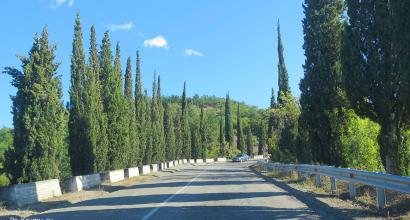
The roads between Alushta and Koktebel are good almost everywhere, a solid 4+. During our time, new fenders were being installed along them:

We didn’t stop by Sudak, we just took pictures of housing prices:

and mountains in its surroundings:

In Koktebel itself, resort life was in full swing as always. It was very crowded:

and automobile:

Cars from all regions of Russia, quite a few from Ukraine, some from Belarus and Germany, and even a couple of Kazakh license plates.

We immediately went to the sea; there were already few people on the beach, but the embankment was full of vacationers and merchants. They sell everything under the sun here - from local fruits and seafood:

to woolen socks (a very necessary item for holidaymakers) and all sorts of overseas exotica. We were hungry as wolves, so we had lunch at the first canteen, the prices are as follows:

Then we walked along the embankment, took pictures of prices in other places and couldn’t resist buying a quarter of a gorgeous homemade cake for dinner:
It was impossible to pass by this beauty! By the way, it turned out to be excellent, the price is 80 rubles per 100 grams. I also liked the different types of natural kvass. We ordered ourselves from tea rose petals and wild pear (the same one that was photographed in the mountains). Yummy!
We decided to return back to Alushta via Simferopol to see how the Tavrida highway was being built. We left Koktebel and soon the bare alien landscapes were replaced by the familiar vegetation of the steppe Crimea.

The road here is not just good, but in many sections it is simply impeccable and a new highway is being actively built, which we, the Crimeans, are looking forward to with great impatience.

We arrived at Alushta in the dark, tired but happy.

To be continued….
The distance to the village of Koktebel Alushta by car is 112 km, the distance in miles is 70. The straight line distance is 73 km. Approximate travel time - 1 hour 48 minutes.
The settlements found along this road route are listed below. The arrival time for each of them is also shown (taking into account time zones). To plan your trip more accurately, please indicate your departure time and average travel speed. You can get information about the passage of a given section of the path in the light or dark of the day. Places you arrive at after sunset will be marked with a special symbol, and places where the time zone is different from the time zone at your starting point will be marked with a symbol.
Check out time: | Speed: |
| Us. points | Time (local) | Dist. | |||
|---|---|---|---|---|---|
Koktebel | |||||
Shchebetovka | 5 km | ||||
| 35 km | |||||
| 39 km | |||||
| 46 km | |||||
| 63 km | |||||
Malorechenskoe | 66 km | ||||
Solnechnogorskoe | 68 km | ||||
| 112 km | |||||
Panoramas
Panorama of the village of Koktebel and Alushta
Driving along a pre-planned route is a way to eliminate problems that may arise in unfamiliar areas and overcome the desired section of the road as quickly as possible. Don’t miss out on details; check the map in advance for all complex road forks.
Don't forget a few simple rules:
- Any driver traveling long distances needs rest. Your trip will be safer and more enjoyable if, having planned your route in advance, you decide on places to rest. The map presented on the site has various modes. Take advantage of the work of ordinary Internet users and use the "People's Map" mode. Perhaps you will find useful information there.
- Do not exceed the speed limit. Preliminary calculation of time and a constructed travel route will help you stay on schedule and not exceed the permitted speed limits. This way, you will not endanger yourself and other road users.
- It is prohibited to use substances that cause alcohol or drug intoxication, as well as psychotropic or other substances that cause intoxication while driving. Despite the abolition of zero ppm (now the possible total permissible error when measuring blood alcohol levels is 0.16 mg per 1 liter of exhaled air), drinking alcohol while driving is strictly prohibited.
The distance Koktebel - Alushta along the highway is 111 km, in a straight line - 76 km. In English countries, the length of this route is 69 miles by road and 47 miles as the crow flies. The trip from Koktebel to Alushta by car will last approximately 1 hour 35 minutes.
The road map is highlighted in red on the map and runs near 2 settlements. To plot the route Koktebel - Alushta for a car and find out how many kilometers between these settlements, the exact coordinates of cities, roads and other geographical objects were used.
Gas stations along the route are shown on the map. The total number of gas stations is 1, including:
Rosneft: 1
To find out what traffic jams are on the Koktebel - Alushta road now, check the “Traffic” box and enlarge the map. To find out how to get from Koktebel to Alushta by car through intermediate cities and towns, list them when calculating the distance. To get a map diagram of the road route in a convenient format, click.
Attention!
To plot the route and calculate the distance, precise satellite coordinates of roads and settlements were used. We do not guarantee 100% accuracy and are not responsible for the route constructed.
It was the first serious lesson in driving in mountainous areas for me and my Zhiguli car, model 6. After many years, this section no longer seems so difficult, since I already have “combat experience” in driving in the northern Caucasus, and there, as you know, the roads are “steeper” and the mountains are higher.
By car
The 110 kilometers of road between Alushta and Sudak are considered one of the most difficult and dangerous throughout Crimea (especially the gap between Sudak and Alushta). In general, if you follow the basic rules of safe driving, this route does not contain anything “deadly dangerous”. Advice!!! I do not recommend driving along this route at night, or when there is ice. The route passes through Shchebetovka, and several other coastal villages (Morskoye, Malorechenskoye). The transfer will take about 2.5 hours.
By bus
Direct bus service between these settlements is provided (and even then only in summer) by irregular carriers; ask for information about them at the bus station. The nearest bus station, from where there are direct flights to Alushta, is located in Feodosia; you can get there from Koktebel by suburban minibus (runs every 40 minutes). Flights to Alushta depart from the bus station starting at 4 am and ending at 10 pm. Travel time is 3.5 hours.

Where to buy tickets
Tickets are sold at the box office of the Feodosia bus station; travel from Koktebel to Feodosia is paid for by the driver.
Fare
Travel to Feodosia costs from 25 rubles, a ticket to Alushta will cost from 220 rubles.
Other options
A taxi from Koktebel to Alushta costs from 4,400 rubles. A custom minibus will cost at least 7,000 rubles. The option of a sea trip is not excluded, because many excursion boats approach the Koktebel pier and go in a western direction (via Alushta). The moving price is determined by the local carrier (from 500 to 2000 rubles).
.jpg)
Why do I love roads? Because they are a reflection of the environment - natural and man-made. The roads of Crimea are fascinatingly picturesque and very difficult. This difficulty is determined by the surrounding landscapes and the imperfections of the road surface. This is felt both on mountain roads (such as the M29 highway) and on steppe roads (such as the M23).
I will show you in today’s post how we saw the Crimean roads and Crimea from the Crimean roads during one of our tours.
That day we had a trip to Alushta. Or rather, a two-day trip by car to the southern coast of Crimea along the route "Alushta - Yalta" with an overnight stay in Utes - the village of Big Alushta.
How we would get from Koktebel to Alushta was not a question. We had already driven along the serpentine along the sea along R 29 (the Alushta - Sudak - Feodosia highway) a week earlier. The trip turned out to be extreme - a wall of rain, a rockfall, the serpentine road was simply killer - long climbs, steep descents, sharp and continuous turns (maybe I’ll write about this later too). It’s not even just a serpentine road with countless loops, it’s also a ride along the ridge of a mountain, its highest point - when there’s nothing at all above the stars... The mileage is only 120 kilometers, but it feels like 500. Although the Google map stubbornly sends nothing unknown newcomers on this road.
For us, I repeat, such a question did not arise. Having driven from Alushta through Simferopol, feeling the familiar, safe route under our wheels, we chose exactly this path. Although we knew that most likely we would immediately rush to Malorechenskoye - another village of Big Alushta - to the Church of St. Nicholas. And maybe from the map it seems that we took a long route and made a detour. But we know that this road is easier and not much longer in time.
As a result, we covered the distance of 190 kilometers - from Koktebel to Malorechensky (via Simferopol and Alushta) along the M29 - M23 - M18 - M29 highways in 3 hours (this is pure travel time). The previous trip to Malorechenskoye directly along the M29 highway took 2 hours 15 minutes. In short, yes, but incomparably more difficult. It's not worth it.
So, let's go!
This is Lenin Street in our dear Koktebel. :) This is the central road that runs through the entire village, fragment P 29. On it we head for Feodosia.

When leaving Koktebel, stunning landscapes open up, thanks to which I can’t help but love these places.

They say that South-Eastern Crimea is not as beautiful as Southern Crimea. Yes, not so beautiful, but beautiful in a different way - in his own way.


The country of Koktebel remains behind us.


We approach the intersection with R 29 and R 23, turn left - towards Simferopol.

I don't know the monument on the right side of the hill. I hope the locals can tell you what the monument is in honor of.

On the left is the Catherine Mile - a restored analogue of the milepost from the time of Catherine II. However, mileposts marked versts, and mileposts marked miles, i.e. they stood every 10 miles. The originals, of course, have not survived. They, as symbols of tsarism, were destroyed during Soviet times.

On the advice of our friend Tatyana, we approached this mile 4 days later.

We looked at her carefully.

There is one grammatical error in the title.

One of the many mosques in Crimea. We noticed that every village, even small ones, on the peninsula has its own mosque. But not everyone has an Orthodox church.


From Grushevka we return to the P 23 highway again.


The roads of Crimea are under active repair - they are laying asphalt of very good quality, changing Ukrainian signs to Russian ones.

I noticed how beautiful the names of the local villages are - Elenovka,

Strawberry, Joyful, Rich, Medicinal... Such telling, cheerful names.

We are entering Belogorsk - a city full of interesting things. The White Rock alone is worth it. And there is also the Taigan lion park.


The road to Simferopol is quite stressful - there are always a lot of cars, there is often no possibility of overtaking, the road surface leaves much to be desired. But it is especially difficult to drive here at night - pitch darkness, narrow road, lack of dividers, a large number of trucks. Not a very pleasant pleasure.
This trip was pleasantly brightened up by the car driving ahead - our radio picked up an Enigma disc playing in it.
Considering that my husband loves this music, and there was nothing else on the radio here, we closely followed this car. It seems like they scared the man. He even tried to break away from us. Did not work out. Arriving in Simferopol, he almost immediately drove away from us. :)

We enter Simferopol.


Lukoil gas station.

We are heading to Yalta.


We are leaving Simferopol. There are numerous trolleybus wires overhead. Who among us doesn’t know about the legendary trolleybus No. 1? Many even rode it. Here he is - the old man.

Yalta is 57 kilometers away.

Alushta is 22 kilometers away.


For those who don’t know, the length of trolleybus lines on the M 18 is 96 kilometers. This is the longest trolleybus system in the world.


The photo above and below shows a view of the Valley of Ghosts and the Dimerdzhi mountain range.


The Livadia Palace is 43 kilometers away. Frankly, for me all these names are just music...

We are entering Alushta. Almost immediately we go left - towards M 29. We go to Malorechenskoye.


This is the same M29 that I wrote about at the beginning of the post, and which cannot be avoided if you need to go to one of the villages on the seashore.