The most destructive tsunami in history. Save who can
Tsunami in Atlantic Ocean
Little is known about tsunamis in the Atlantic Ocean. The frequency of tsunamis and their destructive power in the Atlantic is much less than in the Pacific. Berninghausen gave short description tsunamis that were observed from 1531 to 1960 in the eastern part of the Atlantic Ocean south of the Bay of Biscay (Table 5.21). In his work, he warns that his list is not exhaustive.
20 Order No. 5
Table 5.21. Tsunami in the East Atlantic south of the Bay of Biscay from 1531 to 1960
Epicenter
Note
21/XII 1641
1676 6/V 1706
26/XII 1746 28/IV 1752
31/III 1761
27/XII 1772 1/XI 1775
(?) 1787 23/1 1792
Near Lisbon, Portugal
Azores Same
Canary Islands
Lisbon, Portugal Near Buarcos and Avey. ro, Portugal Lisbon
Azores
Off the coast of Portugal
Portimão, Portugal 38°N latitude, 10° W d.
Azores Same
No earthquakes were recorded
Cape of Good Hope Azores
The waves broke several ships; flooding on the banks of the river. Tacho
Several ships were damaged
Flooding in Port Velas, Fr. Sao Jorge
Coastal destruction. Terceira
Calheta and about. San George
Destroyed Praia da Victoria Tsunami caused by volcanic eruption; destruction in Garachico and on about. Tenerife Tsunami observed The same
A large rise in water in the river. Tahoe
Large waves off the coast of Sao Jorge, Pico and Graciosa Islands 2.4 m high tsunami in Lisbon. Tsunami in Cabo Finistere (Spain), Madeira, Faial, Terceira, Porto Rico, England, Barbados
Tsunami observed near Cabode San Vicente Catastrophic Lisbon earthquake; three tsunami waves ranging in height from 4.6 to 12.2 m led to the destruction of Lisbon; in Cadiz the waves were 5.5 m, in Gibraltar - 2.1 m; big waves were observed in Tangier, Agadir, Madeira, Funchal, Azores
Destructive tsunami Tsunami in Velas and on about. San George
Strong sea in Lisbon
Big Wave in Dining Bay
Tsunami 10 m high on about. Terceira
Large tsunami waves in Velas and on about. Sao Jorge
Epicenter
Note
27-28/VIII 1883 Volcanic eruption
Krakatoa in the Sunda Strait, Indonesia 3/11 1899 Azores
11/V 1911 22/VIII 1926
19/XII 1926 19/XI 1929
31/VIII 1931
22/VI 1939 29/II 1960
Gold Coast Azores
Lisbon 40°N latitude, 56°
Azores
Gold Coast Agadir, Morocco
The amplitude of the waves is about 15.2 cm in the Stolovaya Bay and the strait. English Channel
Destruction in Velas and on about. San George; one person died
Destruction in Lome Tsunami amplitude on Faial and Pico Islands about 60.9 cm Tahoe Tsunami in the Azores, caused by an earthquake in the area of the Great Newfoundland Bank
Destruction in Horta, Feteira, Fr. Faial
Tsunami in Labadi and Tashiya No tsunami confirmed
and perhaps in some cases it includes storm surges rather than tsunamis.
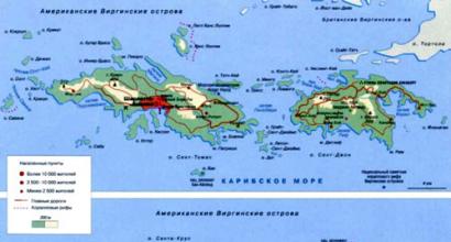
Consider the devastating tsunami that occurred on November 18, 1867 in the Virgin Islands. From that day on, the tremors were repeated until the beginning of 1868 and completely stopped only by 17/111. The height of the tsunami in the hall. St. Thomas was 4.6-6.1 m. There were at least four waves that approached the bay from the southeast between St. Thomas and St. Croix. In Frederiksted on the west coast of about. Santa Cruz, the height of the tsunami ranged from 7.6 to 9.0 m. The tsunami waves flooded about. Saba, the rise was in St. Christopher. In the harbor of St. John on the west coast of about. Antigua tsunami height reached 2.4-3.0 m.
On about. Guadeloupe has been noted several interesting phenomena. In Basse-Terre, the appearance of the tsunami was preceded by the retreat of the sea, and the subsequent rise in level (from the base to the crest) was only 2 m, while in the northwestern part of the island in Deshaus and Sainte-Rose, according to some data, the tsunami amplitude exceeded 18 .3 m. However, according to Reid and Taber, in this case there was an overestimation of the data. On the south side of the island at Pointe-a-Pitre, the tsunami was insignificant, since the approaches to this place were covered. Tsunami data on about. Martinique are missing. On about. St. Vincent, the heights of the tsunami waves were small, but near about. Bequia (16.1-24.1 km to the south) wave height reached 1.8 m. Grenada at St. George's, the sea level first fell by 1.2-1.5 m, and then rose to the same height above its average
position. Vertical fluctuations in the water level were repeated six times. In Gouyave, the amplitude of vertical oscillations reached 6.1 m (according to Reid and Taber, these data are also overestimated). A large tsunami was observed on the southern side of about. Vieques, as well as on the southeast coast of Puerto Rico.
During October-November 1918 there were several earthquakes in Puerto Rico. After the earthquake of October 11, 1918, a tsunami formed with an amplitude of 6.1 m. Several people died in Aguadilla, and damage was caused to the city of Mayagüez.
Of interest are cases of tsunamis on the coast of the Dominican Republic. Thus, after the earthquake of 4/VIII 1946, the tsunami destroyed several settlements. The epicenter of the earthquake was located northeast of Julia Molina, about 64.4 km from the coast. The height of the tsunami in Julia Molina was estimated at about 4-5 m. The city of Matanzas was completely destroyed. About 100 people died. Water level fluctuations were also noted in Samana Bay, but there was no damage.
On June 7, 1962, a strong earthquake occurred on the island of Jamaica. It should be noted that there are disagreements in the description of coastal destruction by tsunami waves. There were reports of an initial retreat of the sea at Ligan and Yalkhauz. In Port Royal, the tsunami amplitude reached 1.8 m, killing 13 people. In St. Ann's Bay on the northern coast of the island, the tsunami appeared almost immediately after the earthquake. Seven waves were noted, caused by reflections between the coasts of Jamaica and Cuba. On the northern less populated coast, the wave amplitude was greater than on the southern one.
On October 3, 1790, a large tsunami wave formed as a result of an earthquake, which hit the west coast of Jamaica and washed away the city of Savanna-La Mar. However, there is some evidence that the devastation was caused by a storm surge and not by a tsunami. About 300 people died. Finally, an earthquake on 14/1, 1907 in the Kingston area led to the formation of a large tsunami wave off the northern coast of the island; on south coast the wave amplitude was insignificant.
Tsunami in Europe
Although not as frequent and destructive as in the Pacific Ocean, tsunamis in Europe and the Mediterranean do occur and take many lives. Ambraceis compiled a list of some of the most famous tsunamis in Europe and North Africa observed from 1900 to 1960 (Table 5.22), and also gave details of the intensity of seismic sea waves (see). Karnik gave a diagram of the location
location of earthquake epicenters, which led to the formation of significant tsunamis in this area (Fig. 5.44).
Table 5.22. Tsunami in Europe
|
Coordinates latitude longitude |
Magnitude, m |
Maximum amplitude, m |
||
|
22/VIII 1926 |
||||
|
20/VIII 1953 |
||||
In this work (p. 203), Karnik singled out a number of coastal regions of the Atlantic Ocean and mediterranean sea, where the tsunami could be observed more often than in other places. It turned out that there are only a few areas that are more or less constantly exposed to seismic sea waves. These areas include the coasts of the Aegean, Adriatic and Ionian Seas, the eastern African coast of the Mediterranean Sea and Portugal. In the eastern part of the Mediterranean, the most frequent tsunamis were observed in the Gulf of Corinth and Euboea, in the area between Himara and Durres, in the Sea of Marmara, in the areas between Cyprus and Acre, Chios and Izmir, south of the Greek archipelago.
Ambraceis gives a detailed list of tsunamis for the eastern Mediterranean. In compiling this list, he excluded from the original sources all unreliable and insufficiently accurate data on the appearance of the tsunami. Moreira points out that from the middle of the XVIII century. most devastating tsunami off the coast of Europe were associated: with the Lisbon earthquake of 1/XI 1755, earthquakes
in Sicily and Calabria on 5/II 1783 and 28/XII 1908, an earthquake in the Aegean on 9/VII 1956
Typically, European tsunamis are local in nature, but some of them can spread over long distances. Examples of such tsunamis are those caused by the Lisbon earthquake of 1755 and, possibly, by the earthquake of 21/VII 365 on about. Crete in the Mediterranean. The waves of this tsunami reached Alexandria in Egypt, Sicily, Calabria in Italy, and probably the Mediterranean coast of Spain.
Rice. 5.44. Tsunami Observations in Europe.
/ - intensity II-III, 2 - intensity III, V.
The causes of at least some tsunamis in Greece are powerful landslides (for example, the tsunami of 9/VII 1956 and 6/VII 1965). However, landslides themselves can be the result of earthquakes. Moreira wrote that the faults, accompanied by landslides, apparently caused the tsunami of 27/IV 1894 in the Gulf of Euboea, as well as the tsunamis of 8/IX 1905 and 28/XII 1908 in Sicily and Calabria. Since in the last two cases there were cable breaks, landslides and turbidity flows most likely took place. Cable breaks also took place during the earthquakes of November 25, 1941 and September 9, 1954.
Some tsunamis are associated with earthquakes, the epicenters of which were on land and were determined quite accurately. These include the tsunami of 1638 near Pisa (Italy), 1694 near Brindisi (Italy), 2/II 1703 on the river. Tiber after a series of earthquakes in the province of Aquila (Italy), in February
1783 in Calabria (Italy), 26/XII 1939 in the Black Sea after an earthquake in Anatolia (Turkey).
28/II 1969 southwest of Cape St. Vincenti (Fig. 5.45) at 36.2° N. latitude, 10.5° W there was an earthquake. A small tsunami was formed, which was registered off the coast of Portugal, Spain, Morocco, the Azores and the Canary Islands. On the coast of Portugal, the wave amplitude was
Rice. 5.45. Travel time curves (min) tsunami 28/1! 1969 in the region of Portugal.
0.8 m, in Casablanca-1 m. The tsunami entered the river. Tacho. On fig. 5.45 also shows the isolines of the travel time of this tsunami.
Let us consider in more detail the tsunami of 9/VII 1956 in the Greek archipelago. It is likely that the formation of the tsunami is associated with landslides that followed a severe earthquake that occurred on the same day. The shores of the islands of the Greek archipelago and Asia Minor are indented by numerous V-shaped bays and separated by narrow straits. The power of the tsunami varied from place to place, the waves reached an amplitude of 30 m. The area affected by the tsunami exceeded 100,000 km2, and the sea fluctuations continued throughout the day. The epicenter of the main shock, which occurred at 03:11:38 CET, had the coordinates 36°54"N, 26°00"E. e. The magnitude was 7.5,
the depth of focus was small. At 03:24:05, an aftershock with a magnitude of 7 was noted at the point 36°48" N, 25°12/E. Figure 5.46 shows the isolines of the travel time of this tsunami.
In table. 5.23 shows the positive and negative amplitudes, the tsunami period and the nature of the initial movement at 33 points of the Greek archipelago. In table. 5.24 list is given
Rice. 5.46. Travel time curves (min) for the 1956 9/VI1 tsunami in the Greek archipelago.
tsunami in the Greek archipelago and surrounding seas from 1400 BC e. to 1956, and in Fig. 5.47 shows the points at which these tsunamis were recorded.
Pararas-Karayiannis described a powerful tsunami associated with a volcanic eruption on about. Santorini (also known as Fr. Thira), which took place between 1450 and 1480 BC. (Fig. 5.48). According to some reports, it was this tsunami that practically destroyed the Minos Empire. Although Pararas-Karayiannis and Bolt and others agree that a catastrophic tsunami could have formed after a volcanic eruption, they question the fact that only the eruption and tsunami crushed the empire.
Huge damage to the countries of Europe was caused by the tsunami that followed the Lisbon earthquake on 1/11/1755.
For a long time there were widespread misconceptions about this earthquake. Reid clarified some of them. He showed that tsunami waves reached the shores of southwestern Europe, northwestern Africa, southern England and Ireland, and the West Indies; WHO-
Rice. 5.47. Cases of tsunami occurrence on the islands of the Greek archipelago and in nearby seas.
it is possible that they were also observed in the western part of the Mediterranean. However, there is no evidence that these waves penetrated the North and Baltic Seas, and there is only a faint hint that they were observed off the coast of America. Three waves were observed in Lisbon, ranging in height from 4.6 to 12.2 m, with greater wave amplitudes to the south of Lisbon than to the north.
Hamilton described the tsunami formed during the earthquake of 5/II 1683 in Italy in the region of Calabria and Messina.
In Scylla, 2473 people drowned, and on about. 24 died in Faro. The tsunami that followed the earthquake in Calabria on December 28, 1908, reached large amplitudes off the coast of the Strait of Messina. The tsunami was observed along the entire northern coast of Sicily as far as Termini. No tsunami was reported north of Cannitello at the entrance to the strait.
Rice. 5.48. The location of the volcanic Santorini (Thira) .
The amplitude of the tsunami varied from 2.7 m near Messina to 8.4 m near Giordini and Ali and up to 8.5 m off the coast of Briga Marina. In addition, the tsunami was near Naples, about. Ischia, Civita Vecchia, Porto Corsini, near Ravenna and Mazzara. Wright points out that this tsunami was not particularly destructive. It gives the value of the wave amplitudes in Messina equal to 2.4, in Reggio - 3.7-4.6. Oldham writes that the sea wave swept over the shores of the Strait of Messina and the Tyrrhenian Sea, fell from a height of 9.1 m on Messina and Reggio, reached at least the coast of Malta and caused the death of three people in Catania.
Table 5.23. Characteristics of the 9/VII 1956 tsunami
|
Primary |
Maximum |
amplitude, m |
||
|
movement |
||||
|
Katapola |
||||
|
Astypalea |
||||
|
Porto Scala |
||||
|
Kalymnos |
||||
|
Leros, Lucky |
||||
|
Patmos, Rock |
||||
|
Marathokambos |
||||
|
Tiganion |
||||
|
Agios Marina |
||||
|
Nisyros, Mandraki |
||||
|
Folegandros |
||||
|
Paros, Parikia |
||||
|
ErM"ION"I |
||||
|
Kythira, Kapsalos |
||||
|
Skopelos |
||||
|
Crete, Sitia |
||||
|
Agios-"Nikolaos |
||||
|
Paleokastron |
||||
|
Heraklion |
||||
|
Rethymno |
||||
|
Attica, Voula |
||||
According to Aumorne, the maximum wave height (6-10 m) was on the coast of Calabria between Pellaro and Lazzaro, on the opposite coast in Platania the waves reached a height of 11.7 m. east coast Waves were observed in Sicily, at the northern tip (Torre di Faro) they reached a height of only 0.8 m, and at the southern tip (Cape Passero) - 1.5 m. Along the northern coast they were observed to Termini, and along the southern - to Porto Empedocle. In the Aeolian Islands, the waves went unnoticed, but they were noted in Malta. In Catania, the sea level recorder was flooded, but in Palermo, Mazzara, Cagliari, Ischia, Napoleon,
Table 5.24. Tsunami in the Greek archipelago and adjacent seas
observation point
1400 1300
426 AD I e.
222 (227?) 62 (65?) 77
21/VII 365 6/IX 543 7 or 9/VII 551 554
14/XII 558 26/X 740 1050
25/XII 1222 14/X 1344 20/1II 1389 3/V 1481 14/IX 1509 8/XI 1612 5/V 1622 5/1V 1646 29/ IX 1650 14/V 1748 8/1 1805 23/VIII 1817 9/1 1821 13/XI 1856 20/X 1859 26/XII 1861 22/1 1866 28/1 1866 October 1866 10/IV 1867 20/IX 1867 5/X 1871 15/IV 1878 28/1 1893 16/IV 1894 27/ XI 1914 25/IV 1928 26/IX 1932 23/1V 1933 9/11 1948 22/IV 1948 9/VII 1956
O. Santorini, about. Crete, Amnisos, Knoos Troad
Colchis, Poti
Gulfs of Maliakos, Opuntian, Atalanta, about. Peparaphos Gulf of Corinth, Helika Rhodes, oh Tilos, Carian and Lucian Fr. Crete
O. Cyprus, Episkopi
O. Crete, Asia Minor
Asia Minor, Cyzik
hall. Maliakos
island of Kos, Dodecanese
Sea of Marmara, Constantinople
Cyclades, Santorini
O. Cyprus, Paphos
Constantinople
O. Chios, Lesbos, Smyrna
O. Rhodes, Dodecanese
Bosphorus, Constantinople
Cretan Sea, Crete
ionian islands
Santorini
Gulf of Corinth, Eion Hall. Patraykos, Patras Gulf of Corinth Ionian Islands Chios Pir e
Gulf of Corinth Chios o. Santorini about. Kitera Lixurion
Ionian Islands, Siroe
Gulf of Corinth
Nicomedia, Prusa
O. Samothrace
Skiathos and Atalanta
Ionian Islands, about. Lefkada
hall. Strymonikos Kos Islands, Dodecanese Karpathos Islands, Dodecanese Ionian Islands, Fr. Lefkada about. Crete
Civita Vecchia, Livorno, Ravenna and Malta received good records. Heesen considered the turbid currents in the Strait of Messina that formed after this earthquake.
Earthquakes in Assam on 15/:VIII 1950 with epicenter 28.6°N. br., 96.5° E led to the formation of seiches in many fjords and lakes in Norway and Great Britain. Mention should be made of the tsunami that was caused by the earthquake in the Aegean Sea on July 9, 1956 with an epicenter of 36°24"N, 25°26"E. d. . The maximum wave amplitude was 4.6 m. The tsunami was observed up to the islands of Kalymnos, Astypalea, Antiparos and the city of Heraklion.
On February 7, 1963, a tsunami was observed in Europe off the coast of the Gulf of Corinth from Patras to Eion. "Belated" underwater mudslides caused by a series of light shocks on February 2, 1963, led to the formation of a tsunami, which reached an amplitude of 2.1-2.4 m with periods of 1-2 minutes. Ambraceis points out in his work that local tsunamis associated with landslides are not uncommon in this area.
Tsunami in the Middle East and Asia
I was able to find only a single mention of a tsunami in the Middle East. It happened in 1837 (more exact data are unknown). The earthquake was felt in Syria, Palestine, in the Jordan Valley. According to the data published in this work, the earthquake caused a strong disturbance in Lake Tiberias.
The tsunami associated with the eruption of Krakatoa in August 1883 was recorded by many stations in India and the Arabian Peninsula. The wave amplitude varied from 0.6 m in Negapatam to 0.02 m in Aden. The earthquake on November 27, 1945 in the Arabian Sea (the epicenter was 290 km from Karachi) led to the formation of a tsunami, which caused destruction in the Bombay region, on the Mahra coast, in Belozhistan and Pasni. Several people died. Walker gives a brief description of two tsunami incidents off the coast of India. One of them is associated with an earthquake in the western part of the Bay of Bengal, when a tsunami was observed in Port Blair in the Andaman Islands and in Doublet near the mouth of the river. Hooghly.
Cox made additions to the list of tsunamis compiled by Behringhausen for South-East Asia. In table. 5.25 shows some cases of the appearance of a tsunami in Indonesia, and in table. 5.26 - in China and Taiwan. Both tables are based on data taken from Cox's work.
Table 5.25. Tsunami in Indonesia
Epicenter
Note
6/III 1710 24/VIII 1757 (?) 1773 (?) 1814 11/IV 1815 (?) 1818 9/IX 1823
28/XI 1836 17/XI 1857
Buitenzorg (Bogor, Java)
18/XI 1857?
20/VII 1859 6/X 1860 23/V 1864
26-27/VIII 1883 Sunda Strait
15/VIII 1968 23/II 1969
Amboina; possibly a storm surge
Amboina Buru
O. Ternate
Inaccurate references to the tsunami
on the Banda Islands
Bandaneira
Jakarta
Coast about. Kalimantan Timor
Madura and Sumbawa Bima Islands (Sumbawa Island)
Presumably tsunami in Jakarta
Bima (Sumbawa)
Kema (northern tip of Su-
Halmahera
hall. gelvink, New Guinea Five waves of tsunami, the last wave is the largest Macassar Strait The same
Table 5.26. Tsunami in China and Taiwan
Note
August (?) AD 173
31/X 1076 Summer 1509
September(?) 1640
19/VIII 1670 22/V 1782
Earthquake in the sea off the coast of Northern China; tsunami in the bays of Bohaiwan, Laizhouwan and off the Shandong Peninsula
Questionable tsunami data in Guangdong Province The earthquake was felt in Wusun (near Shanghai); sea water spills
The tremors were felt in Shantou (Guangdong); there was a tsunami
Earthquake in Suzhou County; many people drowned Taiwan Strait tsunami (possibly storm surge)
Earthquake in the Keelong area (Taiwan); the tsunami caused significant damage, several hundred people drowned
Possible tsunami in Gansu province in northern Central China
In terms of the number of victims and destruction, tsunamis are far from the first place among natural disasters on our planet. But they happen quite often. According to statistics, small tsunamis occur four times a year, and the strongest of them, more than 8 meters high, once a decade. Photo above KPA/COLLECTION FOTO; ALAMY/PHOTAS
On Sunday morning, November 1, 1755, the people of Lisbon were getting ready to celebrate All Saints' Day. Many were already in the cathedrals, listening to the sermons, others were just hurrying there. Suddenly, a dull rumble was heard from somewhere under the ground. Houses shook, in churches huge chandeliers broke off from the ceilings and fell right on the parishioners, plaster and stones rained down. In search of salvation, people rushed into the street to look for open space: someone rushed to the fields, but most to the harbor to sail away in boats. A miraculously surviving eyewitness, who found himself along with everyone on the embankment, Reverend Charles Davy, later said that when the tremors subsided, there was complete calm and silence. A few minutes later, a wall of water appeared on the horizon from the ocean, instantly growing to the size of a mountain. She hit the embankment with great force, covering people. The monk grabbed hold of a large beam lying on the ground, and this saved his life, as the water receded as suddenly as it rolled over. As he was all wet, he returned to the city and from there saw a picture of monstrous destruction: the lower part of Lisbon was flooded, and in the harbor, like chips, ships were spinning, some with torn tackle or turned upside down.
It was one of the most destructive tsunamis in the memory of people, paired with an earthquake that destroyed the most beautiful city in Europe, and what was spared by the water element was destroyed by the fire that started.
The danger of a tsunami for people is in its suddenness, which is why in many cases the tragedy occurs according to a similar scenario. First, the earthquake destroys houses and drives the townspeople out into the street, then there is a lull and a tsunami follows. Those who were lucky enough to avoid the first wave begin to return to their homes, thinking that the worst is over, and then they are covered by the second, and then the third wave. And these repeated tsunamis destroy many more lives, because the water quickly fills the coast, devastated after the first onslaught, and just as quickly recedes, dragging defenseless people who have nothing to even grab onto.
The largest catastrophic tsunami recent years, caused by an earthquake, occurred on December 26, 2004. Its epicenter was in the Indian Ocean off the island of Sumatra. The tremor provoked an ocean wave that hit the coasts of several countries in Southeast Asia, reaching 30 meters in places. Almost 300,000 people died or are still considered missing.
After this disaster, tsunamis of lesser strength repeatedly disturbed oceanic islands and coasts in the Pacific and Indian Oceans. On April 2, 2007, a ten-metre-high wave washed away two coastal villages and flooded the towns of Taro and Gizo in the Solomon Islands. The source of the earthquake was located about 300 kilometers east of them at a depth of ten meters under the bottom of the Pacific Ocean.
 A tsunami hits the shores of Sri Lanka in 2004. Satellite imagery. Photo: FOTOBANK.COM/SIPA PRESS |
A textbook example of a volcanic eruption that caused a tsunami is the Krakatoa eruption in Indonesia in 1883. A monstrous explosion that shook the ocean floor gave rise to a wave 40 meters high, the echoes of which were recorded by instruments in the English Channel between England and France. The tsunami completely destroyed the cities of Marak, Anyer, Tyaringan, and only an insignificant part of their population survived the catastrophe.
Large waves generated by the collapse of large stone or ice blocks into the water are also referred to as tsunamis. One of the most devastating events of its kind happened on July 9, 1958 in Alaska. After the earthquake (which in itself did not become a direct cause of the tsunami), a part of the glacier with a volume of about 300 million cubic meters collapsed into Lituya Bay from a height of 900 meters. On the opposite side of the bay, a wave surge 600 meters high appeared. A huge wave swept across the bay, ripping off the trees from the slopes. At that time, there were three ships in the bay, 10 kilometers from the center of the disaster. One of them was thrown by a wave across the island over the tops of twelve-meter trees and rocks.
Is it possible to know in advance about the occurrence of a tsunami and warn people? For those caused by earthquakes, the prediction is possible because the speed of the seismic wave is much higher than the speed of the sea. And having fixed a strong push with a magnitude above 7, seismologists are already raising the question of the possibility of a tsunami. But it will not come to the shore immediately. The gain in time can be minutes and even hours - it all depends on the remoteness of the epicenter of the earthquake. If he was on land, then the tsunami should not be feared at all. Sometimes strong earthquakes at the bottom of water areas do not generate tsunamis. Only real recording of a wave, namely a local rise in the level of the ocean or sea, serves as an indisputable confirmation of a tsunami, but, unfortunately, most of the mareographic points where such measurements are made are located near the coasts, which greatly reduces the time allotted for warning the population about the danger.
The first in the world was organized by the Pacific Tsunami Warning Center - in 1948 after the disaster that occurred two years earlier on Hawaiian Islands.
The Japanese warning system has been in operation since 1952 and relies on a very dense network of seismic stations. Of particular danger to this country are tsunamis that occur on its western coasts, during earthquakes in the Sea of Japan. So, in May 1983, several dozen people died there. The fact is that the time of giving a warning signal is 13 minutes, and the first waves approached the shore 9 minutes after the shock, in some areas - after 3 minutes. To avoid future casualties, Japan has created local systems where the possibility of a tsunami is estimated from seismic data at a single point. In the event of an unfavorable forecast in a tsunami-prone area, the gas and electricity supply is automatically turned off, television and radio programs broadcast a warning text, turn on street sirens, and begin evacuating the population.
In the USSR, the warning service began to be created after the North Kuril tragedy of 1952. After all, the seismicity of this region is one of the highest in the world. Along the Kuril-Kamchatka island arc there is an extremely active earthquake belt, as well as a chain active volcanoes about 2000 kilometers long. Unfortunately, this service was eliminated in the 1990s, and now the only advantage over the danger of a tsunami is the small population of far east coast.
Tsunami is a formidable natural phenomenon that is formed as a result of volcanic eruptions or earthquakes in coastal areas. This is a giant wave that covers the coast for many kilometers inward. The term "tsunami" is of Japanese origin, it literally sounds like " a big wave in the Gulf". It is Japan that most often suffers from the strikes of the elements, because it is located in the zone of the Pacific "Ring of Fire" - the largest
Causes
A tsunami is formed as a result of "shaking" billions of tons of water column. Like circles from a stone thrown into the water, the waves scatter in different directions at a speed of about 800 km per hour to reach the shore and splash out on it in a huge shaft, destroying everything in its path. And often, people caught in the tsunami area have a matter of minutes to leave. dangerous place. Therefore, it is very important to warn residents about the threat in time, sparing no means for this.
The largest tsunami in the last 10 years

A terrible tragedy occurred in the Indian Ocean in 2004. An underwater earthquake with a magnitude of 9.1 caused the appearance of giant waves up to 98 m high. Within a few minutes they reached the coast of Indonesia. In total, 14 countries were in the disaster zone, including Sri Lanka, India, Thailand, and Bangladesh.
It was the largest tsunami in history in terms of the number of victims, which reached 230 thousand. Densely populated coastal areas were not equipped with danger, which was the reason for so many
dead. But there could have been much more victims if the oral traditions of the individual peoples of these countries had not preserved information about the tsunami in antiquity. And some families said that they managed to escape the dangerous place thanks to the children who learned about the giant waves in the classroom. And the retreat of the sea, before returning in the form of a deadly tsunami, served as a signal for them to run higher up the slope. This confirmed the need to educate people on how to behave in an emergency.
The largest tsunami in Japan
In the spring of 2011, disaster struck. an earthquake with a magnitude of 9.0 occurred off the coast of the country, which led to the emergence of waves up to 33 m high. Some reports noted other figures - water crests reached 40-50 m.

Despite the fact that almost all coastal areas have dams to protect against tsunamis, this did not help in the earthquake zone. The death toll, as well as those carried into the ocean and missing, totals more than 25 thousand people. People across the country anxiously read the lists of victims of the earthquake and tsunami, afraid to find their relatives and friends in them.
125 thousand buildings were destroyed, damaged transport infrastructure. But the most dangerous consequence was the accident at a nuclear power plant. It almost led to a nuclear catastrophe on a global scale, especially since radioactive contamination affected the waters of the Pacific Ocean. The forces of not only Japanese power engineers, rescuers and self-defense forces were sent to eliminate the accident. The leading nuclear powers of the world also sent their specialists to help save them from an ecological catastrophe. And although now the situation at the nuclear power plant has stabilized, scientists still cannot fully assess its consequences.

Tsunami warning services alerted the Hawaiian Islands, the Philippines and other areas at risk. But, fortunately, already greatly weakened waves no more than three meters high reached their shores.
So the most large tsunamis over the past 10 years have occurred in the Indian Ocean and in Japan.
Major Disasters of the Decade
Indonesia and Japan are among the countries where destructive waves happen quite often. For example, in July 2006, a tsunami again formed in Java as a result of a devastating underwater shock. Waves reaching 7-8 m in places swept along the coast, capturing even those areas that miraculously did not suffer during the deadly tsunami of 2004. Residents and guests of the resort areas again experienced the horror of helplessness before the forces of nature. In total, 668 people died or went missing during the rampage of the elements, and more than 9 thousand sought medical help.

In 2009, a major tsunami happened in the Samoa archipelago, where almost 15-meter waves swept through the islands, destroying everything in their path. The number of victims was 189 people, mostly children, who were on the coast. But the operational work of the Pacific Tsunami Warning Center made it possible to avoid even greater human losses, allowing people to be evacuated to safe places.
The largest tsunamis in the last 10 years occurred in the Pacific and Indian Oceans off the coast of Eurasia. But this does not mean that such catastrophes cannot happen in other regions of the globe.
Devastating tsunamis in human history
Human memory has preserved information about the giant waves observed in antiquity. The oldest is the mention of a tsunami that happened in connection with a volcanic eruption on the island of Greater Santorini. This event dates back to 1410 BC.
It was antiquity. The explosion lifted most of the island into the sky, leaving in its place a depression instantly filled with sea water. From a collision with hot magma, the water boiled abruptly and evaporated, intensifying the earthquake. The waters of the Mediterranean Sea heaved up, forming giant waves that hit the entire coast. The ruthless element took 100,000 lives, which is a very large number even for modern times, let alone for ancient times. According to many scientists, it was this eruption and the resulting tsunami that led to the disappearance of the Cretan-Minoan culture - one of the most mysterious ancient civilizations on Earth.
In 1755, the city of Lisbon was almost completely wiped off the face of the earth by a terrible earthquake, the fires that arose as a result of it, and a terrible wave that washed over the city afterwards. 60,000 people died and many were injured. The sailors from the ships that came to the port of Lisbon after the disaster did not recognize the surrounding area. This trouble was one of the reasons for the loss of the title of great maritime power by Portugal.

30 thousand people were victims of the 1707 tsunami in Japan. In 1782, a disaster in the South China Sea claimed the lives of 40,000 people. Krakatoa (1883) also caused a tsunami, which caused the death of 36.5 thousand people. In 1868, the number of victims of huge waves in Chile amounted to more than 25 thousand. 1896 was marked by a new tsunami in Japan that claimed more than 26,000 lives.
Alaskan tsunami
An incredible wave formed in 1958 in Lituya Bay in Alaska. It was also caused by an earthquake. But there were other circumstances as well. As a result of the earthquake, a giant landslide, amounting to about 300 million cubic meters, descended from the slopes of the mountains on the coast of the bay. m of rocks and ice. All this collapsed into the waters of the bay, causing the formation of a colossal wave that reached a height of 524 m! Scientist Miller believes that even before that, the largest tsunami in the world took place there.
A blow of such force hit the opposite shore that all vegetation and a mass of loose rocks were completely demolished on the slopes, and a rocky base was exposed. Three ships that ended up in the bay at an unfortunate moment had different fates. One of them sank, the second crashed, but the team managed to escape. And the third ship, being on the crest of a wave, was carried over the spit separating the bay and thrown into the ocean. Only by a miracle the sailors did not die. Then they recalled how during the forced "flight" they saw the tops of trees growing on the spit below the ship.
Fortunately, the shores of Lituya Bay are almost deserted, so such an unprecedented wave did not cause any significant harm. The largest tsunami did not cause great loss of life. Only 2 people are believed to have died.
Tsunami in the Russian Far East
In our country, the tsunami-prone zone includes the Pacific coast of Kamchatka and the Kuril Islands. They also lie in a seismically unstable region, where there are frequent and destructive earthquakes and volcanic eruptions.
The largest tsunami in Russia was recorded in 1952. Waves reaching a height of 8-10 meters hit the Kuril Islands and Kamchatka. The population was not prepared for such a turn of events after the earthquake. Those who, after the cessation of tremors, returned to the surviving houses, for the most part never got out of them. The city of Severo-Kurilsk was almost completely destroyed. The number of victims is estimated at 2336 people, but there may be many more. The tragedy that happened a few days before the 35th anniversary of the October Revolution was hushed up for years, only rumors circulated about it. The city was moved to a higher and safer place.
The Kuril tragedy became the basis for organizing a tsunami warning service in the USSR.
Lessons from the past

A strong earthquake of magnitude 6.7 occurred in the Atlantic Ocean off the coast of Brazil, at a very shallow depth of only 6 miles, and it is impossible to determine whether it caused a TSUNAMI, since all but one of the Atlantic tsunami warning buoys are OFFLINE and cannot report warnings.
The East Coast could be at risk if such a wave goes around, but we can't be warned because the US Department of Commerce has been unable to repair the buoys.
The quake struck at 1:33 AM EST, at a depth of only 6 miles.
According to the Tsunami Warning Center, there is "no tsunami danger" for the US East Coast. I wonder how they can make this assessment, given the fact that our tsunami warning buoys are NON-FUNCTIONAL.
Here is the Statement issued by the Tsunami Warning Center:
WEXX32 PAAQ 300646
TIBATE
Tsunami Information Statement Number 1
NWS National Tsunami Warning Center Palmer AK
146 AM EST Thu Nov 30 2017
…THIS IS A TSUNAMI INFORMATION STATEMENT FOR THE U.S. east coast,
GULF OF MEXICO STATES AND EASTERN CANADA…
* Based on the earthquake location near the Mid-Atlantic Ridge,
a damaging tsunami is not expected.
* An earthquake has occurred with parameters listed below.
PRELIMINARY EARTHQUAKE PARAMETERS
———————————
* The following parameters are based on a rapid preliminary
assessment and changes may occur.
* Magnitude 6.5
* Origin Time 0133 EST Nov 30 2017
0033 CST Nov 30 2017
0233 AST Nov 30 2017
0633 UTC Nov 30 2017
* Coordinates 1.1 South 23.5 West
* Depth 6 miles
* Location near the central Mid-Atlantic Ridge
ADDITIONAL INFORMATION AND NEXT UPDATE
————————————–
* Refer to the internet site tsunami.gov for more information.
* Caribbean coastal regions should refer to the Pacific
Tsunami Warning Center messages at tsunami.gov.
* This will be the only U.S. National Tsunami Warning Center
message issued for this event unless additional information
becomes available.
If they are correct, we have nothing to worry about. If, they are NOT correct, the tsunami travels through the open ocean at about 600 miles per hour. First hit the northern coast of Brazil. IF WE HEAR THAT BRAZIL HAS BEEN HIT WITHIN THE NEXT TWO HOURS, THEN WE WILL BE HIT IN APPROXIMATELY FOUR HOURS.
First by North Carolina. Minutes later, southern Delaware and New Jersey would be hit. Minutes after that, New York and Long Island. At about the same time that New York is under attack, the entire southeast will also be attacked.
The National Buoy Data Center (NDBC) is part of the National Oceanic and Atmospheric Administration (NOAA), which is part of the US Department of Commerce.
According to the NDBC, the following tsunami warning buoys (listed south to north as the southernmost buoy will be closest to the quake) in the Atlantic, OFFLINE:
Tsunami is a word of Japanese origin and literally means "long waves in the port." Later, the scope of this concept was expanded, and today it means any long destructive waves. A lot is said about a tsunami, a lot is written, but it is very difficult to imagine it. Probably the best idea of what a tsunami looks like at sea is someone who has seen the movie The Adventures of Poseidon, in which the tsunami is depicted truly magnificently. According to the plot of the film, the tsunami arose as a result of an earthquake near the island of Crete. Underwater earthquakes are indeed the most common cause the origin of the tsunami. However, it can also be caused by an underwater volcanic eruption, and the collapse of the coast.
Rice. 23. Scheme of earthquakes in the Eastern Mediterranean. Conventional signs indicate the epicenters of earthquakes that occurred in 1961–1967, taking into account the depths of their sources. In the Aegean basin, earthquakes are especially frequent, but mostly shallow. On the contrary, deep earthquakes predominate around Sicily. The tectonic map of the Mediterranean was reconstructed according to the depths of earthquake sources (it is shown in Fig. 21). In the Aegean basin we see an arc of young volcanoes characteristic of this region. (According to D. Stanley, 1972)
Tsunamis are very long and high waves, and the wave height in the open ocean is not so great, only a few meters. But when the wave front penetrates into smaller shelf areas, the wave rises and turns into a huge wall, the height of which can reach several tens of meters. The speed of the tsunami is greater, the greater the depth of the ocean. For example, in the open waters of the Pacific Ocean, whose depth is about 4–5 km, the theoretically possible wave speed is almost unbelievable - 716 km/h. After all, it is, in essence, the speed transport aircraft. In fact, the speed of the tsunami is much less. However, the maximum noted speed was even higher, approximately 1000 km / h, and this is the speed of a jet aircraft.
Tsunamis, of course, occur more often where earthquakes occur more often, that is, in the area of the underwater trenches of the Pacific Ocean. These earthquakes generate waves that crash on the shores of Japan, the Kuril Islands and other island arcs. Earthquakes in the area Aleutian Islands cause tsunamis that sweep across the Pacific Ocean, flood the coasts of the Hawaiian Islands and even reach California. Tsunamis, caused by earthquakes in the Peru-Chile Trench, hit the coast of Chile with devastating force. And even in the Mediterranean, earthquakes generate tsunamis. The most significant of them took place off the coast of Corsica and Sicily. In the Atlantic Ocean, tsunamis occur mainly as a result of earthquakes in the Azores-Gibraltar ridge. And then they flood the Portuguese coast.

Rice. 24. Map of the so-called "earthquake risk" in the Eastern Mediterranean. Isolines connect points with the same earthquake energy. The figures express the energy in 1015 erg km -2 - year -1. (According to K. Lomnitz, 1974)
A classic example of a tsunami resulting from a volcanic explosion is the tsunami generated by the eruption of the Krakatau volcano in Indonesia. This happened in 1883. A wave 36–40 m high was formed due to the collapse of part of the island. A few minutes later she reached the coast of Java and Sumatra. The wave passed through all the oceans and was even registered in Panama, 18,350 km from the point of origin.
And now we should once again mention the small island of Thira in the Cyclades archipelago, where a 100 m high tsunami may have occurred around 1500 BC (see p. 91). However, there is no eyewitness evidence of this phenomenon, and the height and consequences of the tsunami were calculated only by comparing the sizes of the Krakatoa and Thira calderas. Half an hour later, a terrible wave was supposed to reach Crete and mainland Greece, an hour later Egypt. As we have already mentioned, some authors believe that this was the biggest natural disaster of the historical era, which had a direct impact on the death Minoan civilization. According to some atlantologists, it was she who could cause the death of Atlantis. With many debatable questions related to this topic, we argue on p. 93–95.
The third reason for the occurrence of a tsunami is the collapse of the coast. And although this phenomenon is not so frequent, and most importantly, not so large-scale, it can still cause a wave that reaches impressive proportions. Here is one example of many. In the Lituya Bay in Alaska, 30 million m 3 of soil slipped into the sea, as a result of which the water surface rose by 600 m and a huge surf wave hit the opposite shore of the bay. At this height, traces of its destructive impact are still visible.
In table. 8 collected data on some of the most famous tsunamis of the historical era.
| Table 8. Some of the largest tsunamis of the historical era (according to various sources) | |||
| Year | Place | Cause | Wave speed and height |
| Around 1500 BC | O. Thira | Volcanic explosion and caldera formation | Extrapolation calculated that the wave could reach a height of 100 m and a speed of 200 km/h; she captured the entire region of the Eastern Mediterranean |
| 1737 | Kamchatka, Kuriles, Sakhalin | Wave height 17–35 m, speed probably 700 km/h | |
| 1854 | Japan | Earthquake in the Japan Trench | A 9 m high wave passed over the entire Pacific Ocean in 12.5 hours; in San Francisco, a height of 0.5 m is recorded |
| 1872 | bay of bengal | Cause unknown, possibly as a result of storm surge | Wave height 20 m (200,000 victims) |
| 1883 | Krakatoa | Volcanic explosion, caldera formation | Wave height 35–40 m in Java and Sumatra; speed about 200 km/h; noted even 18,000 km from the explosion site |
| 1908 | Messina | Earthquake in the Messina Trench | Wave height 23 m |
| 1946 | Hawaiian Islands | Earthquake in the Aleutian Trench | Wave height in Hawaii 10 m, speed in the open ocean 700 km/h |
| 1952 | Kamchatka and the Kuriles | Earthquake in the Kuril-Kamchatka Trench | Wave height 8–18 m, speed about 500 km/h |
| 1953 | Alaska | Earthquake in the Aleutian Trench | Wave height 17–35 m, speed about 700 km/h |
| 1960 | Chile | Earthquake in the Peru-Chile Trench | Three cycles of waves; the highest is about 11 m at a speed of 700 km/h; an 8 m high wave hit Hawaii, the same wave near Hokkaido had a height of 6 m |
Interesting descriptions of eyewitnesses of this natural phenomenon. Among them is even such an authoritative specialist as one of the founders of modern marine geology, the American Francis Shepard. By chance, he was on vacation in the Hawaiian Islands just when a destructive wave hit them in 1946. Eyewitness accounts are important for the conclusion about how rapidly such a catastrophe is developing, as well as whether it can be compared with the death of Atlantis described by Plato. If we compare the testimony of authoritative experts, we can draw the following conclusions: at first, the sea, as it were, recedes and the water level drops. Then comes the first wave a few meters high. After a few minutes, it subsides and after 5–10 minutes a second wave runs up, sometimes the same height as the first, sometimes a little lower. After 10–20 minutes, it also subsides, and then, usually after an hour, sometimes after a longer period of time, the third, highest and most destructive wave rolls. If a wave breaks into a bay, its height increases significantly. Waves throw very heavy loose objects ashore, tear off rocks, sweep away houses and even the concrete foundations of lighthouses.
Now we have a clear idea of what a tsunami can do and how long it lasts. The whole disaster lasts no more than an hour or two. During this time, the entire coastal zone of the mainland or island, or even the entire island, can be completely destroyed. As we have already said, many historians are sure that a large share of the blame for the death of the Minoan culture on the island of Crete lies with the tsunami. Some atlantologists also believe that the tsunami is to blame for the destruction of Atlantis. And this would not have required "one terrible day," as Plato claims. An hour would be enough. Thus, a tsunami is such a catastrophe that theoretically, given the appropriate scale, could easily destroy Atlantis.