The Caribbean Sea is a geographical location in the world's oceans. Caribbean beauty
CARIBBEAN SEA, Caribbean Sea, a semi-enclosed marginal sea in the western part of the tropical Atlantic Ocean. In the west and south it is limited by the mainland coasts of Central and South America, in the north and east - by the ridge of the Greater Antilles (Cuba, Haiti, Puerto Rico) and the Windward Islands from the Lesser Antilles group. It is connected by the Yucatan Strait with the Gulf of Mexico, by numerous straits in the archipelagos of the Greater and Lesser Antilles with the Atlantic Ocean, and by the Panama Canal with the Pacific Ocean. Area 2777 thousand km2, volume 6745 thousand km3. The greatest depth is 7090 m (Cayman Trench).
The coasts of Central America are low-lying and wooded, while those of South America are mostly high and steep, with isolated low areas covered with mangroves. The coasts of most islands are mountainous and steep. The western and partly southwestern coasts of the sea are fringed by reefs. The main large bays are located in the western and southern parts of the sea: Honduras, Mosquitos, Darien, Venezuelan Gulf with Lake Maracaibo, Paria. Of the large islands - Jamaica; many small islands, most of them in the western and southeastern parts of the sea.
The shelf is well defined only off the coast of Honduras, Nicaragua and Venezuela (100-240 km), the continental slope is steep, on average about 17°, in some sections of the slope a steepness of up to 45° is noted. On the bottom, strongly dissected by underwater ridges, deep basins stand out: Yucatan (4800 m), Colombian (4259 m), Venezuelan (5420 m), Grenada (4120 m). In the north of the Caribbean Sea, the deep-sea Cayman Trench stretches from west to east along the southern foot of the underwater ridge of the same name. Most of the underwater ridges (Aves, Beata, Marcelino threshold, etc.) appear to be submerged island arcs. Bottom sediments are mainly represented by calcareous foraminiferal silts. An important factor in sedimentation for the flat relief of basins is turbidity currents; the heaviest precipitation was found in the north of the Venezuelan basin (up to 12 km).
 The climate is marine, warm, with little seasonal variability, determined by the location of the Caribbean Sea in the zone of trade wind circulation of the atmosphere. Average air temperatures in February are 24-27 °C, in August 27-30 °C. The amount of precipitation increases from east to west from 500 to 2000 mm per year. The highest average monthly precipitation falls in summer off the coast of Panama (up to 400 mm), the least in winter off the coast of Cuba (about 20 mm). Northeast trade winds prevail over the sea at speeds of 5-7 m/s. Storm conditions are usually associated with tropical hurricanes, in which wind speeds reach 40-60 m/s. Hurricanes cross the Caribbean Sea in the western and northwestern directions at a speed of 10-20 km/h with an average frequency of 3 times a year (in some years more than 10).
Water exchange with the Atlantic Ocean occurs mainly through deep straits: Windward, Sombrero, Dominica, etc.; with the Gulf of Mexico - through the Yucatan. Seas are predominantly in the eastern and north-eastern directions, on average 3-4, rarely 5 points. The magnitude of annual level fluctuations is small and usually ranges from 8 to 30 cm. Short-term level fluctuations are observed during the passage of tropical hurricanes. The tides are irregular semidiurnal, off the coast of Venezuela - irregular diurnal, up to 1 m.
 Water circulation is set by the branches of the Antilles Current and the Guiana Current, entering the Caribbean Sea through the northern and eastern interisland straits. These waters spread in a westerly direction called the Caribbean Current. In the eastern part of the sea, the current moves in two streams at a distance of 200-300 km from each other. At about 80° west longitude both streams merge into one. The current speed in the western part of the sea reaches 70 cm/s. Off the coast of Cuba and Jamaica, the current forms several anticyclonic gyres; cyclonic eddies are observed along the coasts of Venezuela, Panama and Costa Rica. The waters of the Caribbean Current are carried through the Yucatan Strait into the Gulf of Mexico. In the strait, the highest speeds of surface currents from the side of the mainland coast are up to 150 cm/s.
The surface water temperature varies throughout the year from 26 °C in winter to 29 °C in summer. The deep-sea basins are filled with Atlantic waters with a temperature of about 4.3°C. The average salinity of water on the surface is from 35.5 to 36.5‰. By the end of the summer season, due to the abundance of precipitation and fresh river flow, salinity decreases by 0.5-1.0‰, its lowest values (33-34‰) near the islands of Trinidad and Tobago are explained by the large fresh flow of the Orinoco River. The highest salinity of surface waters is in a narrow strip off the coast of South America and the coasts of Haiti and Cuba (over 36‰).
There are about 800 species of fish in the Caribbean Sea, more than half of which are edible. Of the commercial fish, the most important are representatives of the families of snapper, serranidae, sea crucian carp, several species of mullet, croaker, as well as sardinella, horse mackerel, mackerel, tarpon, and anchovies. Widespread fish of the open ocean are tuna, marlin, sailfish, common lionfish, and sharks.
The Caribbean coast is known for its beautiful beaches and is the largest recreational area with numerous resorts. Busy shipping; passes the sea route through the Panama Canal, connecting the Atlantic and Pacific oceans. Main ports: Santiago de Cuba (Cuba), Santo Domingo (Dominican Republic), Maracaibo (Venezuela), Barranquilla and Cartagena (Colombia), Colon (Panama).
Lit.: Zalogin B.S., Kosarev A.N. Seas. M., 1999. M.G. Deev.
Caribbean sea water temperature. Caribbean Sea coastal water temperature
The data given shows the surface water temperature on the coasts of seas and oceans. To view the values, select the country and then the city that interests you.
10 Fun Facts About the Caribbean
In addition to water temperature, we also provide information on the weather for today, tomorrow and the coming days, surf forecast, sea conditions and waves, sunrise/sunset data and moonrise data.
List of countries and territories in the Caribbean Sea
Water temperature in the Caribbean Sea by month:
Water temperature in the Caribbean Sea in January
Water temperature in the Caribbean Sea in February
Water temperature in the Caribbean Sea in March
Water temperature in the Caribbean Sea in April
Water temperature in the Caribbean Sea in May
Water temperature in the Caribbean Sea in June
Water temperature in the Caribbean Sea in July
Water temperature in the Caribbean Sea in August
Water temperature in the Caribbean Sea in September
Water temperature in the Caribbean Sea in October
Water temperature in the Caribbean Sea in November
Water temperature in the Caribbean Sea in December
To calculate sea temperature, satellite data are used together with observation results from ground stations.
Water temperature, weather forecast and sea conditions are updated daily. Temperatures in shallow areas near the shore may be slightly higher than those shown here.
Caribbean location: Western part of the Atlantic Ocean, between Central and South America.
Area of the Caribbean Sea: 2,754 thousand km2
Average depth of the Caribbean Sea: 2,491 m.
Greatest depth of the Caribbean Sea: 7,680 m (Cayman Trench).
Bottom reliefCaribbean: deep-sea ridges (Cayman, Aves, Beata, Marcelino threshold), basins (Grenadian, Venezuelan, Colombian, Bartlett, Yucatan).
SalinityCaribbean: 35.5-36 ‰.
CurrentsCaribbean Sea moving from east to west, when leaving the Gulf of Mexico they give rise to the Gulf Stream.
Inhabitants of the Caribbean: sharks, flying fish, sea turtles and other types of tropical fauna; There are sperm whales, humpback whales, seals and manatees.
Additional information about the Caribbean: The Caribbean Sea borders the Gulf of Mexico; the shortest sea route passes through it, connecting the ports of the Atlantic and Pacific oceans through the Panama Canal.


Caribbean Sea Wikipedia
Site search:
Caribbean Sea: where it is on the map, photos, area, depth, rivers, fish, countries, cities
Caribbean Sea- a semi-enclosed sea in the Atlantic Ocean, located between Central and South America. Countries washed by the Caribbean Sea: Venezuela, Colombia, Panama, Cuba, Guatemala, Costa Rica, Haiti, Jamaica, Nicaragua, etc.
Area: 2,754,000 sq.
Caribbean Sea - corals, animals, tourism, pirates, interesting facts
km. Average depth: 2500 m. Greatest depth: 7686 m.
The following rivers flow into the Caribbean Sea: Plantaine Garden, Magdalena, Rio Grande, San Juan, Coco, Aguan, Motagua, Rio Hondo, etc.
Resort cities located by the sea: Cancun (Mexico), Varadero (Cuba), Montego Bay (Jamaica), Bridgetown (Barbados), Freeport (Bahamas), etc.
Major ports in the Caribbean: Cartagena (Colombia), Santiago de Cuba (Cuba), Maracaibo (Venezuela), Colon (Panama), Limon (Costa Rica), Santo Domingo (Dominican Republic), Kingston (Jamaica).
Large bays: Mexican, Honduras, Venezuelan, Darien, Batabano, Gonave, Guacanaiabo, Paria.
The most important islands of the Caribbean: Antilles, Bahamas, Cayman, Turneffe, Islas de la Bahia. Largest island: Cuba.
Animal life: angelfish, silky shark, hawksbill turtle, barracudas, moray eels, tuna, lobsters, sardines, monk seal, razorback crocodile, etc.
Photos of the Caribbean Sea:


Where is it on the map:
Oceans, lakes and rivers
Caribbean Sea
The Caribbean Sea belongs to the Atlantic Ocean and is located in the tropics of the Western Hemisphere. In the northwest, the reservoir borders the Yucatan Peninsula (Mexico) and connects to the Gulf of Mexico through the Yucatan Pass between Yucatan and Cuba.
To the north and east there are large and small Antilles. In the south, the sea is washed by the northern coast of South America. To the west and southwest is the coast of Central America. Caribbean waters are connected to the Pacific Ocean through the Panama Canal.

geography
The reservoir is considered one of the largest in the world.
Its surface is 2.754 thousand square meters. km. The amount of water is 6,860 thousand cubic meters. km. Maximum depth 7686 meters. It is installed in a so-called trench candle. It is located between Jamaica and the Cayman Islands.
This is an underwater trough between the North American and Caribbean plates. The average depth of the reservoir is 2500 meters.
member
Many countries erase many seas. In South America these are Venezuela and Colombia. In Central America: Panama, Costa Rica, Nicaragua, Guatemala, Honduras and Belize.
The last in this series is the Yucatan Peninsula. The northern part is occupied by 3 Mexican states, and in the south there are territories belonging to Belize and Guatemala.
In the northern part of the Greater Antilles there are countries such as Cuba, Haiti, Dominican Republic, Jamaica and Puerto Rico.
The Antilles region is home to countries such as Antigua and Barbuda, Barbados, Dominica, Grenada, Saint Kitts and Nevis, Saint Lucia, Saint Vincent and the Grenadines, Trinidad and Tobago.

Caribbean on the map
islands
Those who don't know should know that the Bahamas never belonged to the Caribbean. They are located north of Cuba and south of Florida. These are Atlantic waters, and historically this area is called the West Indies.
It covers both the Caribbean and the Bahamas. This term appeared when Columbus discovered America.
In the body of water in question there are the Antilles, divided into large and small. The first includes four large islands: Cuba, Haiti, Jamaica and Puerto Rico. This includes small islands located close to Cuba and form the archipelagos of Los Canareos and Jardines de la Reina.
The smaller Antilles are much more numerous.
They are influenced by the north-east trade wind and are divided into wind, rain or south. The first group has about 50 islands. The southern group extends along the coast of South America and includes both individual islands and archipelagos.
Closer to the western coast of the reservoir there are several archipelagos. These are the Cayman Islands (Grand Cayman, Mali Cayman, Cayman Brac), the Department of Island Bay Islands, which are located in Honduras, as well as the islands of Misquitos and Turneffe.
There are separate islands of San Andres and Providencia.
Rivers
There are many rivers in a large body of water. The largest of them is the South American Magdalene River. It passes through Colombia and is 1,550 km long. The annual flow is the largest at approximately 230 cubic meters.
km. Another Colombian river is called Atrato. Its length is 644 km. Some rivers go to Lake Maracaibo (the largest in South America). The Caribbean Sea is connected to the Gulf of Venezuela by a small slope, the depth of which does not exceed 4 meters.
In Central America we also feed about 30 rivers.
There are rivers on the islands. For example, the Cauto River in Cuba. Its length is 343 km. But the Artibonite River in Haiti is 240 km long. There are rivers in Jamaica. This is the river of milk and the black river.
climate
The climate is tropical. It is created by the Subtropical Caribbean Current, a continuation of the Southern Trade Trend. Hot water flows from southeast to northwest and passes through the Yucatan Channel in the Gulf of Mexico, where the Gulf Stream originates.
Therefore, the annual temperature ranges from 21 to 29 degrees Celsius.
Windmills are dominated by trade winds. Their speed ranges from 16 to 30 km/h. There are tropical hurricanes in the northern part of the reservoir. Their speed can reach 120 km/h. Such strong winds sometimes cause real tragedy: people die, houses are destroyed, cultures die.
For example, Hurricane Mitch, created in the western part of the sea in October 1998, brought a lot of sadness. 11 thousand people were killed, and the same number was not enough. There were 2.7 million people without housing. They were mostly citizens of Nicaragua and Honduras.

economy
The Caribbean Sea is inextricably linked with oil production.
Approximately 170 million tons are produced offshore.
Caribbean Sea: “A true paradise on earth”
tons of oil per year. In addition, the fishing industry is well developed. Sea water annually provides up to 500 thousand tons of fish. However, human activities pollute the environment. Firstly, this negatively affects coral reefs, which are constantly bleached and their ecosystem is destroyed.
This could impact the tourism industry in the best possible way in the near future. Every year about 40 million tourists visit the region. The net profit from them is about 30 billion dollars. Many tourists are attracted by diving and the beauty of coral reefs. About 3 million locals living on the islands are somehow associated with a tourism company. Therefore, environmental problems are quite acute.
Sergey Gubanov
Before you find out where the Caribbean islands are on the world map, you need to get some general information about them. They include the Antilles, which rise significantly above sea level, as well as the Bahamas islands of coral reefs. Most of them are of volcanic origin. Some islands are surrounded by large coral reefs, the peaks of which protrude from the water and are overgrown with palm trees.
The Greater Antilles include four large landmasses that extend from the mainland, including Puerto Rico, Jamaica, Haiti and Cuba. The Lesser Antilles include a scattering of small lands, which include the Bahamas, Caicos, Turks, Burbuda, Antigua, the Virgin Archipelago, Guadeloupe, Barbados and so on.

Hard to say, what country is the caribbean islands, since these include all land areas washed by the Caribbean Sea.
Moreover, parts of the archipelago territorially belong to different states. Previously, they were known to the world as the legendary Antilia, then as the West Indies, and only then as the Caribbean, comfortably located inside a peculiar geographical depression between South and North America.
Some of the islands are uninhabited, but most of them still have a developed resort network. Today, about fifty islands are destinations for visitors from all over the world.
The popularity of these latitudes is explained by the harmonious combination of a mild climate, rich historical heritage, and picturesque natural landscapes.

An important advantage of the Caribbean is the opportunity to relax all year round, because it is never cold here, eternal summer and sunny weather reign.
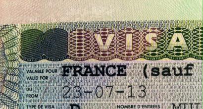
The need for visas becomes a big issue. It is tourists who are constrained by visa restrictions who are most interested in Caribbean Islands is where what countries they belong to. The Caribbean includes more than fifty islands, some of which are separate states, while others are considered the territorial property of France, America and England. However, most areas of the Caribbean do not require their guests to have a visa.
All cruises operate from Mexico, the Dominican Republic and the USA, so you still need to get to the departure city by plane, so lovers of cruise travel will still not be able to do without a visa. The most common cruise destinations are the Eastern, Southern and Western Caribbean. It is also worth noting that the cost of the trip depends on the number of islands included in the route.

Which Caribbean Islands to Visit
Among the huge list of Caribbean sites, there are several areas that are the most popular.
After a tourist understands where the Caribbean islands are located, he needs to make a specific choice of where to go on vacation.
To do this, you should familiarize yourself with the basic information known about most resorts. Some of them are distinguished by a developed tourist network, others make travelers fall in love with their remoteness from the usual civilization. Domestic tourists, as a rule, choose among the following offers:

The list can be continued for a very long time.
It is noteworthy that before you go traveling, you should also look at the weather of the Caribbean islands by month, which will allow you to make the right choice.

Weather in the Caribbean
Weather conditions for different land areas belonging to the same archipelago may vary slightly.
However, in general the climate ranges from humid to temperate tropical. It is worth noting that the humidity index for any island will remain consistently high, which promotes excellent growth of various types of vegetation.
The air is always cleaner and drier in mountainous areas. The air temperature here does not drop below +25 degrees. The water off the coast remains warm all year round, its temperature does not drop below +22 degrees.
Caution should be exercised when planning a vacation in these latitudes from September to November. Since this period is characterized by increased rainfall with possible hurricanes.

The local summer is characterized by moderate heat, which is alleviated by the trade winds blowing from the sea.
The peak of tourism occurs from December to April, so domestic travelers often celebrate the New Year here.
From August to November, the so-called “Low Season” begins in the Caribbean. It is worth noting that it is quite difficult to predict a Caribbean holiday, because on one part of the land there may be torrential downpour, and on another the sun may be shining brightly. Thus, it is important not only to look at photos of the beaches of the Caribbean islands on the Internet, but also to read reviews from tourists who have already vacationed here.
1. Name and history
2. Geology
3. Relief
There are two deep passages in the Greater Antilles chain: the Anegada Strait and the Windward Strait. The depth of the Anegada Strait varies from 1950 to 2350 m, the windward channel - from 1600 to 1630 m.
| The numbers indicate: 1. Gulf of Honduras 2. Gulf of Mosquitos 3. Gulf of Darien 4. Gulf of Venezuela 5. Lake Maracaibo 6. Guacanaiabo 7. Gulf of Gonaves 8. Island of Trinidad 9. Cayman Islands |
3.1. Coastline
The coastline of the sea is heavily indented, the shores are mountainous in some places, low-lying in others (Caribbean lowland). The shallow areas contain various coral deposits and numerous reef structures. On the continental coast (western and southern part of the sea) there are several bays, the largest of which are: Honduras, Mosquitos, Darien and Venezuela. In the northern part are the bays of Batabano, Ana Maria and Guacanaybo (the southern coast of the island of Cuba), as well as the Gulf of Gonave (the western part of the island of Haiti).
There are several bays on the east coast of Yucatan, including Ascencion, Espiritu Santo and Chetumal. The Gulf of Honduras ends in Amatique Bay, located on the border of Belize and Guatemala. The northern coast of Honduras is slightly indented, and several lagoons cut into the Mosquito Coast, including the lagoons of Caratasca, Bismuna, Perlas and Bluefields Bay. In the east of Panama is the large Chiriqui Lagoon. Off the coast of South America, the Gulf of Darien ends with the Gulf of Uraba, and is fenced off by the Guajira Peninsula of the Gulf of Venezuela - Lake Maracaibo. To the west of the island of Trinidad lies the Gulf of Paria, which is considered part of the Atlantic Ocean.
3.2. Islands
The surface subtropical Caribbean Current, passing from the southeastern to the northwestern part of the sea, is a continuation of the Northern Trade Wind Current, its flow is estimated at 26 million m / s. The trade wind drives the waters to the west, off the coast of Central America the current turns north and through the Yucatan Strait goes into the Gulf of Mexico. The current speed is 1-2.8 km/h, in the Yucatan Strait it increases to 6 km/h. The current is warm, with a water temperature of around 28 C and a salinity of less than 35.5 due to the significant contribution of fresh water from the Amazon and Orinoco. Water pumped from the Caribbean Sea into the Gulf of Mexico raises the level of the latter relative to the main part of the Atlantic Ocean (the water level off the west coast of Florida is 19 cm higher than on the east coast), which creates hydrostatic pressure, which is believed to be the main driving force of the Gulf Stream .
In the southwestern region of the sea, between the coasts of Colombia and Nicaragua, there is a circular current swirling counterclockwise throughout almost the entire year. Tides in the Caribbean Sea are mostly irregular semidiurnal, with an amplitude of less than 1 m.
During the rainy season, the waters of the Orinoco River create high concentrations of chlorophyll in the eastern part of the sea. The Cariaco Basin, located off the coast of Venezuela, is interesting because hydrogen sulfide is constantly present in it, and a high concentration of methane has been found in the Cayman Trench.
4.1. Caribbean Sea Basin
The Caribbean Sea is located in Central and South America. The largest river flowing into the Caribbean Sea is the Magdalena (1550 km) with its tributaries Cauca and Cesar. Its annual flow is 228 km, or an average of 7.2 thousand m/s (data from 1942 to 2002). The rivers Atrato (annual flow - 81 km), Leon (2.1 km) and Turbo (12 km) flow into the Gulf of Uraba and the Gulf of Darien. Other South American rivers include the Dique (9.4 km) and Son (11.8 km), as well as the Catatumbo and Chama, which flow into Maracaibo, the continent's largest lake.
On the coast of North America, the rivers Belen, Cricamola (flows into the Chiriqui Lagoon), Teribe and Sixaola (Panama), Chirripo Atlantico, Reventazon and San Juan (Costa Rica), Indio, Punta Gorda, Rio Escondido flow into the Caribbean Sea. and Curinas, Rio Grande de Metagalpa, Prinsapolca, Bambana, Cucalaya, Huahua and Coco (Nicaragua), Patuc, Sico Tinto, Agua, Ulua and Chamelecon (Honduras), Motagua and Rio Dulce (Guatemala), Belize River , New River, Rio Hondo (Belize).
Island rivers: Cauto and Sasa (Cuba), Artibonite and Caude del Sur (Haiti island), Black River and Milk River (Jamaica).
5. Climate
The Caribbean Sea has a tropical climate, which is influenced by the trade wind circulation. Average monthly air temperatures vary from 23 to 27 C. Cloudiness is 4-5 points.
Average annual rainfall in the region varies from 250 mm on the island of Bonaire to 9000 mm in the windward parts of Dominica. Northeast trade winds prevail with average speeds of 16-32 km/h, but tropical hurricanes occur in the northern regions of the sea, the speed of which can exceed 120 km/h. On average, 8-9 such hurricanes occur per year from June to November, with the most frequent in September - October. According to the US National Hurricane Center, from 1494 to 1900, 385 hurricanes passed over the Caribbean, and from 1900 to 1991, 235 similar manifestations of the elements were recorded. The Caribbean Sea region is less prone to hurricane damage than the Gulf of Mexico or the Western Pacific Ocean (where typhoons occur from May to November). Most hurricanes form in the Cape Verde Islands and are sent by trade winds to the shores of America; in general, it is impossible to predict the exact trajectory of a hurricane.
Severe hurricanes cause loss of life, destruction and crop failures in the region. The Great Hurricane of 1780, which raged from October 10 to 16, 1780, caused enormous damage to the Lesser Antilles, Puerto Rico, the Dominican Republic, and possibly the Florida Peninsula, and resulted in the deaths of 22 to 24 thousand people. Hurricane Mitch, which occurred on October 22, 1998 off the coast of Colombia, passed through Central America, the Yucatan and Florida peninsulas, causing damage of 40 million US dollars and killing 11-18 thousand people. Hurricanes Galveston (1900) and Fifi (1974) also caused significant damage to the region.
6. Flora and fauna
According to faunal zoning, the Caribbean Sea region belongs to the Caribbean region. The region is characterized by great biodiversity, many species are endemic.
6.1. Vegetable world
The region's vegetation is predominantly tropical, but differences in topographic, soil and climatic conditions increase species diversity. The islands' porous limestone terraces tend to be nutrient-poor. An estimated 13,000 plant species grow in the Caribbean, of which 6,500 are endemic, such as the guaiac tree (the flower of which is the national symbol of Jamaica) and the mahogany tree (the national flower of the Dominican Republic). In coastal areas, the coconut palm is common; in lagoons and river estuaries there are dense thickets of mangroves (red and black mangrove trees).
In shallow waters, flora and fauna are concentrated around coral reefs, the growth of which is facilitated by almost constant stable temperature, clean water and small changes in salinity levels. Submerged seagrass fields occur in lagoons on the leeward sides of reefs. A total of seven species of algae are found in the Caribbean Sea. The most common are Thalassia testudinum and Syringodium filiforme (Tsimodoceevi family), which can grow both together and in single-species fields at depths of up to 20 m. Another type of Cymodoceuceae - Halodule wrightii - grows on sand and mud surfaces at depths of up to 5 m. m. In the brackish water of harbors and river estuaries at depths of 0-2.5 m, the sea rupee (Ruppia maritima) is found. Representatives of three species belong to the genus Halophila (Halophila baillonii, Halophila engelmanni and Halophila decipiens) live at depths of up to 30 m. Halophila engelmanni does not grow below 5 m, the range of this species is limited to the Bahamas, Florida, the Greater Antilles and the western Caribbean. The species Halophila baillonii has only been found in the Lesser Antilles.
6.2. Animal world
The mammals of the Caribbean region are represented by 90 species, including sperm whales, humpback whales and Delphinus. Seals and American manatees live near the island of Jamaica. The region was previously home to the Caribbean monk seal, which is now considered extinct. Representatives of the slittooth family are under threat of extinction.
Reptiles of the Caribbean region are represented by 500 species (94% endemic). The islands are home to several endemic species of cycluras, with the common sharp-snouted crocodile being widespread. Several species of sea turtles are present in the region: Trichechea spp., loggerhead (Caretta caretta) green turtle, devil, leatherback turtle, Atlantic ridley (Lepidochelys kempii) and olive turtle (Lepidochelys olivacea). Some species are in danger of extinction, their population, according to researchers, has decreased greatly since the 17th century - the number of green turtles has decreased from 91 million to 300 thousand individuals, and demons - from 11 million to less than 30 thousand by the year.
There are 600 bird species recorded in the Caribbean, 163 of which are endemic to the region, such as the then-Cuban-billed woodpecker and the stonechat. From endemics, 48 species are threatened with extinction: Puerto Rican Amazon, Cuban epaulette, Cuban wren, etc. The Antilles, near Central America, lie on the migratory route of birds from North America, so bird population sizes are subject to strong seasonal fluctuations. Parrots, sugarbirds and toucans are found in the forests, and frigates and phaetons can be found over the open sea.
7. Ecology
The main factors influencing the global change in the characteristics of the Caribbean Sea are considered to be global warming and sea level rise (it is expected that it will rise by 86.36 cm by year), rising sea temperatures causing coral bleaching and algal blooms, as well as changes in precipitation patterns and the corresponding river flow and even dust brought by sandstorms from the Sahara. Shipping, which generates about 82 thousand tons of garbage per year, oil transportation and land-based sources of pollution negatively affect the ecological state of the sea.
Currently, no more than 23 thousand km (10%) of indigenous forests remain on the Caribbean islands. In Cuba, where the largest forests of the island part of the region are located, less than 15% of the forests have remained intact; the rest were cut down during the development of the territories.
7.1. Corals
The Atlantic Ocean contains about 9% of the world's coral reefs. Their area is 50 thousand km, with most of them located off the coast of the Caribbean islands and Central America. . One of the most studied phenomena in the region recently is coral bleaching. Until the 1980s, Madrepore corals were widespread in the Caribbean Sea; over the next 20 years, due to anthropogenic and natural reasons, their population decreased, and the amount of seaweed increased. In 1983, this process was exacerbated by the mass death of sea urchins that feed on algae. Scientific research on the reefs was conducted from 1995 to 1998 off the coast of Belize on the largest coral barrier reef in the Northern Hemisphere, as well as nearby reefs in the eastern sea. The warming of the Caribbean Sea (as a result of global climate change) threatens the fragile ecosystems of coral reefs - prolonged water temperatures above 29 C lead to the death of microscopic algae zooxanthellae. These plants provide food and color to corals, so their death leads to coral bleaching and disruption of the entire reef ecosystem.
Reef inhabitants are important for tourism activities such as fishing and diving, which in 2000 were estimated to generate US$3.1–4.6 billion annually for the region.
7.2. Nature protected areas
The total area of protected areas on the islands of the West Indies is 30 thousand km (13% of the region's land surface). In Cuba, about 15% of its territory is protected (including the Zapata swamp with an area of 4354.3 km, the Alexander Humboldt and Desembarco del Granma National Park), in Dominica - a little more than 20% (including the Morne-Trois-Piton National Park) , in the Dominican Republic - about 15% (Jaragua National Park, etc.). In other countries there are almost no protected areas.
Among the protected areas along the continental coast are: Sian Ka'an Nature Reserve, Chinchorro (Mexico), Biological Reserve on the Misquitos Islands (Nicaragua), Darien National Park (Panama), Los Catios and Tayrona National Parks (Colombia), Medanos de Coro National Park , Henry Peter National Park, El Avila, Mochim and Laguna de la Restinga (Venezuela).
8. Economy and economic importance
More than 116 million people live on the Caribbean coast (within 100 km of the coast), whose main source of income is tourism (15.5% of all jobs in the region). More than 300 thousand people are employed in the fishing industry. Fishing volumes are estimated at slightly less than half a million tons of seafood per year. Main commercial species: Caribbean spiny lobsters (Panulirus argus), giant strombus (Strombus gigas), flagellated shrimp (Penaeidae), Cavalli mackerel (Scomberomorus Cavalla), Spanish mackerel (S. maculatus), large coryphaena hippurus, SERIOL (Seriola spp.) and others. Industrial pearl harvesting.
8.1. Shipping and trade
From an economic and strategic point of view, the Caribbean Sea plays the role of the shortest sea route from the ports of the Atlantic Ocean through the Panama Canal to the Pacific Ocean. The main ports of the Caribbean Sea: Maracaibo and La Guaira (Venezuela), Cartagena (Colombia), Limon (Costa Rica), Santo Domingo (Dominican Republic), Colon (Panama), Santiago de Cuba (Cuba) and others.
The complex system of communication and trade in the Caribbean region ensures high turnover, but most of it occurs in countries located outside the region. Traded goods and resources within the region are few: rice from Guyana, timber from Belize, gasoline from Trinidad and Curacao, salt, fertilizers, vegetable oils and fats from the eastern islands, and a small amount of industrial products. The consumers of most of the products produced in the region (bananas, sugar, coffee, rum, bauxite, nickel and oil) are the United States and Canada.
8.2. Tourism
Thanks to its warm climate and beautiful beaches, the Caribbean region is one of the main resort areas in the world. The rich marine fauna attracts divers; in addition to its natural beauty, the region is rich in cultural monuments of pre-Columbian civilizations and the colonial era. The tourism industry is an important component of the Caribbean economy, serving primarily tourists from the United States, Canada, Brazil and Argentina. Air traffic between North America and the Caribbean is better developed than within the region. According to the Caribbean Tourism Organization, 22,700,000 tourists visited the region in the year, and 19,200,000 people took part in cruise tours. The most popular destinations include the Dominican Republic, Cuba, Mexico (Cancun, Riviera Maya), Jamaica, the Bahamas and Puerto Rico.
9. Culture
The rich history of the Caribbean has inspired numerous authors to create various cultural works related to piracy. Daniel Defoe, Robert Louis Stevenson, Rafael Sabatini and other writers have worked on pirate themes; many films have been created on this topic (including the Pirates of the Caribbean film series and the cartoon Treasure Island), and numerous computer games have been released. The lives and customs of the people of the Caribbean have been described by such authors as the Cuban writer Alejo Carpentier, the Dominican writer (and president) Juan Bosch, Derek Walcott (St. Lucia) and the Colombian writer Gabriel García Márquez.
The Caribbean region is home to various musical genres: reggae, ska in Jamaica, merengue and bachata in the Dominican Republic, calypso in Trinidad and Tobago. Reggaeton originates from Puerto Rico and Panama, son and son Montuno originate in Cuba, cumbia, poro and vallenato appear on the Caribbean coast of Colombia.
One of the most popular sports in the Caribbean is baseball, and there is a separate baseball tournament, the Caribbean Series. Cricket is also common in the English-speaking Antilles, and football is popularized in CONCACAF member countries. The region hosts the Central American and Caribbean Games, and national teams also take part in the Pan American Games.
10. Ports
Notes
- http://www.britannica.com/EBchecked/topic/95846/Caribbean-Sea - www.britannica.com/EBchecked/topic/95846/Caribbean-Sea
- Great Soviet Encyclopedia. Caribbean Sea - www.cultinfo.ru/fulltext/1/001/008/059/220.htm (Russian)
- "International Bathymetric Chart of the Caribbean Sea and the Gulf of Mexico" - www.ngdc.noaa.gov/mgg/ibcca/ibcca.html. NOAA . http://www.ngdc.noaa.gov/mgg/ibcca/ibcca.html - www.ngdc.noaa.gov/mgg/ibcca/ibcca.html. Retrieved 2009-04-23 .
- G. Samuels (RSMAS) .. "Animation of monthly temperature changes in the Caribbean" - assets.panda.org/img/original/monthly_temperatures_caribbean.gif. WWF . http://assets.panda.org/img/original/monthly_temperatures_caribbean.gif - assets.panda.org/img/original/monthly_temperatures_caribbean.gif. Verified 2009-04-30 .
- S. Heileman, R. Mahon .. "Large Marine Ecosystems - Caribbean Sea" - www.lme.noaa.gov/index.php?option=com_content&view=article&id=58:lme12&catid=41:briefs&Itemid=53. NOAA www.lme.noaa.gov/index.php?option=com_content&view=article&id=58:lme12&catid=41:briefs&Itemid=53. Retrieved 2009-04-23 .
- Judy Gray, Doug Wilson (NOAA/NODC). (2004). "Animation of changing salinity distribution in the Caribbean" - assets.panda.org/img/original/monthly_salinity_caribbean.gif. WWF . http://assets.panda.org/img/original/monthly_salinity_caribbean.gif - assets.panda.org/img/original/monthly_salinity_caribbean.gif. Verified 2009-04-30 .
- The Oceans, Their Physics, Chemistry, and General Biology, p. 638
- Template: From TSB
- Joanna Gyory, Arthur J. Mariano, Edward H. Ryan.. "The Caribbean Current" - oceancurrents.rsmas.miami.edu/caribbean/caribbean.html. University of Miami . http://oceancurrents.rsmas.miami.edu/caribbean/caribbean.html - oceancurrents.rsmas.miami.edu/caribbean/caribbean.html. Retrieved 2009-03-11 .
- The Oceans, Their Physics, Chemistry, and General Biology, p. 642
- Luis Ernesto Medina Faull.. "Descargas fluviales en las Zonas Costeras" - www.dhn.mil.ve/noticia/noticia6.html. Direccin de hidrografa y navegacin de Venezuela . http://www.dhn.mil.ve/noticia/noticia6.html - www.dhn.mil.ve/noticia/noticia6.html. Retrieved 2009-03-11 .
- "Caribbean Sea" - slovari.yandex.ru/dict/geography/article/geo/geo1/geo-1998.htm. Dictionary of Modern Geographical Titles . http://slovari.yandex.ru/dict/geography/article/geo/geo1/geo-1998.htm - slovari.yandex.ru/dict/geography/article/geo/geo1/geo-1998.htm .
- Institute of Oceanology RAS. (1997). "hydrothermal mechanism of hydrocarbon formation in mid-ocean ridges" - www.geolib.ru/OilGasGeo/1997/08/Stat/stat01.html. geolib.ru . http://www.geolib.ru/OilGasGeo/1997/08/Stat/stat01.html - www.geolib.ru/OilGasGeo/1997/08/Stat/stat01.html. Retrieved 2009-03-07 .
- John B. R. Agard, Angela Cropper, et al. (2007). - UNEP . Retrieved 2009-04-23 .
- Philip Dickenson Peters. Caribbean Wow 2.0 Zagada Markets. 2003 isbn 1929970048 - books.google.com/books? id = tXbo9H6t1TcC
- Orlando Frez. (1970).
The area of the Caribbean Sea is 2,754,000 km². The average depth is 1225 m. The average volume of water is 6860 thousand km³.
The sea is located on the Caribbean lithospheric plate. It is divided into five basins, separated from each other by underwater ridges and strings of islands. The Caribbean Sea is considered shallow compared to other bodies of water, although its maximum depth is approximately 7,686 meters (in the Cayman Trench between Cuba and Jamaica).
The shores are mountainous in places, low-lying in others; in the west and near the Antilles they are bordered by coral reefs. The coastline is heavily indented; in the west and south there are bays - Honduras, Darien, Venezuela (Maracaibo), etc.
The Caribbean Sea is one of the largest seas in the transition zone, separated from the ocean by a system of island arcs of different ages, of which the youngest, with modern active volcanoes, is the Lesser Antilles arc. More mature island arcs form large islands - Cuba, Haiti, Jamaica, Puerto Rico with an already formed continental (northern part of Cuba) or subcontinental crust. The island arc of the Cayman - Sierra Maestra is also young, expressed for the most part by the underwater Cayman Ridge, accompanied by the deep-sea trench of the same name (7680 m). Other underwater ridges (Aves, Beata, Marcelino sill) appear to be submerged island arcs. They divide the bottom of the Caribbean Sea into a number of basins: Grenada (4120 m), Venezuela (5420 m). Columbia (4532 m), Bartlett with the deep-sea Cayman Trench, Yucatan (5055 m). The bottoms of the basins have a suboceanic type crust. Bottom sediments are calcareous foraminiferal silts, in the southwestern part - weakly manganese, calcareous silts, in shallow water - various coral deposits, including numerous reef structures. The climate is tropical, influenced by trade wind circulation and characterized by great homogeneity. Average monthly air temperatures range from 23 to 27 °C. Cloudiness 4-5 points. Precipitation amounts range from 500 mm in the east to 2000 mm in the west. From June to October in the north. Tropical hurricanes are observed in parts of the sea. The hydrological regime is highly homogeneous. The surface current, under the influence of trade winds, moves from east to west. Off the coast of Central America, it deviates to the northwest and leaves through the Yucatan Strait into the Gulf of Mexico. The current speed is 1-3 km/h, near the Yucatan Strait up to 6 km/h. The Gulf of Mexico is an intermediate basin for waters that come from the Atlantic Ocean and, when leaving the Gulf of Mexico into the ocean, give rise to the Gulf Stream. Average monthly surface water temperatures range from 25 to 28 °C; annual fluctuations are less than 3 °C. Salinity is about 36.0 ‰. Density 1.0235-1.0240 kg/m3 The color of the water is from bluish-green to green. The tides are predominantly irregular semidiurnal; their size is less than 1 m. The vertical change in hydrological characteristics occurs to a depth of 1500 m, below which the sea is filled with homogeneous water coming from the Atlantic Ocean; its temperature is from 4.2 to 4.3 °C, salinity is 34.95-34.97‰. The Caribbean Sea is home to sharks, flying fish, sea turtles and other types of tropical fauna. Sperm whales and humpback whales are found, and seals and manatees are found near the island of Jamaica.
The Caribbean Sea is of great economic and strategic importance as the shortest sea route connecting the ports of the Atlantic Ocean and the Pacific Ocean through the Panama Canal. The most important ports are Maracaibo and La Guaira (Venezuela), Cartagena (Colombia), Limon (Costa Rica), Santo Domingo (Dominican Republic), Colon (Panama), Santiago de Cuba (Cuba), etc.
The name "Caribbean" is derived from the Caribs, one of the dominant American Indian tribes that lived on the coast at the time of Columbus's contact with the natives in the late 15th century. After the discovery of the West Indies by Christopher Columbus in 1492, the Caribbean Sea was called the Sea of Antilles, in honor of the Spaniards who discovered the Antilles. In various countries, the Caribbean Sea is still confused with the Antilles Sea.
Today, not only every schoolchild, but even preschoolers know that somewhere on Earth there are Caribbean islands. But not every adult can answer the question of where exactly these Caribbean islands are located. Today we will try to restore this gap and go on a virtual trip to the islands of the Caribbean.
How to get to the Caribbean Islands?
The Caribbean Sea, as well as the Caribbean islands, are comfortably located between the two Americas - South and North. Getting here is quite simple - you just need to buy an air ticket and a ticket to a paradise is already in your hands. Airlines such as Air France, KLM Royal Dutch Airlines, British Airways and Virgin Atlantic regularly fly here. Some Caribbean islands can only be reached with transfers, having first purchased an air ticket to Canada or the USA.
Caribbean Islands - what country is this?
Tourists constrained by visa restrictions, of course, cannot help but be interested in which state the Caribbean islands belong to. In total, the Caribbean includes more than fifty islands, some of which are separate independent states, while others are the property of England, America, and France. But tourists can rest easy - a visa is simply not needed to enter the territory of most of the Caribbean islands.
Where is the capital of the Caribbean islands?
Given the diversity of the political map of the Caribbean islands, it is naturally impossible to talk about their single capital.
Islands of the Caribbean - names
All the islands that make up the Caribbean are usually divided into three groups:
- Greater Antilles. These include Haiti, Puerto Rico, Jamaica and the Cayman Islands.
- Lesser Antilles, which includes about 50 islands, such as Barbados, Dominica, Grenada, Antigua, Martinique, St. Thomas, Tobago, Trinidad, etc.
- Bahamas, which includes about 30 inhabited islands and more than 2,000 coral reefs.