Preparing to climb Munku Sardyk. Climbing the sacred mountain Munku-Sardyk
Climbing Munku-Sardyk (3491 meters) - the highest point of the Sayan Mountains - is a serious test for trained tourists. In summer the route is quite simple, but in winter its complexity increases significantly: short daylight hours, negative air temperatures, icy snowy slopes - all this makes the climb difficult.
- 6 years of experience in organizing winter ascents
- Dozens of climbers of different ages have reached the summit
- Upon completion, a certificate of ascent is issued, as well as a commemorative badge of the tourist club
- All necessary group winter equipment is provided
This region of the Eastern Sayan Mountains compares favorably with the rest due to its lack of snow. In the foothills there is almost no snow at all. This allows you to hike and climb on foot, without skis or snowshoes. Also for the area in winter time clear frosty weather is typical. Average temperatures are -25°…-35°С, which for us residents middle zone Russia may seem very impressive. But for the Eastern Sayan region this is not so much; children continue to go to school, since the air is dry and such temperatures are tolerated much more easily than here.
The peak of Munku-Sardyk is located on the very border of Russia and Mongolia. Climbing this inaccessible peak requires excellent physical fitness and sufficient sports training. Only in this case will you be able to climb the majestic peak.


The ascent to Munku-Sardyk passes through the most beautiful and harsh places, the passage through which brings a lot of positive emotions and impressions. The highlight of the area is the abundance of ice and icefalls; you are unlikely to see such huge blue icefalls anywhere else. Well, visiting Lake Baikal in winter is also worth a lot. We will spend the night in a special tent-hangar “Artiktika” for winter hikes with a stove so we don’t freeze.
Why choose us?
Equipment rental
We will provide you with quality equipment at a reasonable price. You have the opportunity
travel lightly and save a lot of money.
This route has been successfully completed by our club many times, all organizational details have been checked and worked out to the smallest detail.
Discount
Those who go on a hike with our tourist club for the second or more time receive a discount on participation from 5%.
Great climb
A personal manager will advise you at all stages of preparation, help you get ready for your trip, and give recommendations on purchasing tickets and equipment.
Fill out the application and, closer to the start, make a small advance (from 10%) in the most convenient way for you. The rest of the amount is due on the start day.
Reliability
Our tourist club is officially registered, enters into contracts and pays taxes. Experienced instructors on the routes. Only modern and high-quality equipment is used.
1. Route and requirements 2. Hiking plan 3. Cost of participation 4. Equipment recommendations
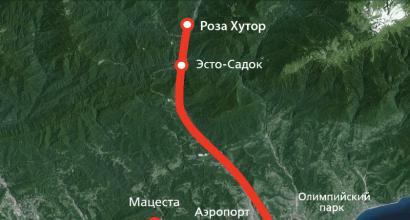
Slyudyanka station - Lake Baikal - Kyren village - Mondy village - White Irkut river - Muguvek river - Mount Munku-Sardyk (3,491 meters) - White Irkut river - Zhemchug village - Lake Baikal - Slyudyanka station.
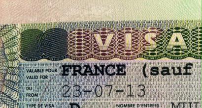
Required documents: passport, medical insurance policy
Physical training requirements for participants: The ascent is quite difficult, it requires both physical and technical preparation, good equipment, taking into account the winter conditions of the ascent

1 day
Meeting at the Slyudyanka railway station. The city of Slyudyanka is located on the shores of Lake Baikal, a 2-hour drive from Irkutsk. The city is connected with Irkutsk by regular by bus(minibuses depart from the bus station every 30 minutes), and there are also electric trains. The group gathers before lunch, local time, since several trains arrive around lunchtime, which the participants usually take to get there. Those who arrive earlier can still take a walk to Lake Baikal. Next, transfer by car to the mountains; the journey takes 4-5 hours. Along the way, stop in the Buryat village of Kyren for a snack in a cafe. Throw to a height of approximately 1,600 meters. Setting up camp, overnight.


Day 2
Along the frozen river, on ice up the valley of the White Irkut River. Gradually, the river is surrounded by high rocks, the river flows in a canyon. At the top through a cascade of blue icefalls. The transition from Camp 1 to Camp 2 takes about 5 hours. On the way we stop for lunch. The final section is quite steep and consists of a cascade of low waterfalls. It requires crampons, some years even rope to hold on. Overnight on the border of the forest, at an altitude of approximately 2,100 meters.


Day 3
The ascent climbs along a wide valley to a frozen lake. The journey takes 3-4 hours. The forest is left behind, only snow and rocks are ahead. Setting up an assault camp at an altitude of 2,600 meters.


4 day
Early rise. Climbing to the highest point of the Sayan Mountains - Munku-Sardyk (3,491 meters). At the top there is a rise in crampons. There are often strong winds, which, combined with frosty weather, poses a serious challenge. The peak of Munku-Sardyk is located right on the border of Russia and Mongolia. It offers a beautiful view to the south, Lake Khubsnugul and the surrounding area. Descent along the ascent path.


5 day
Reserve day in case of bad weather. If you're lucky with the weather, you can go back down to the edge of the forest and climb the blue waterfalls.


Day 6
Descent in the valley of the White Irkut River. A chartered bus awaits us at the bottom of the road. We are going to Slyudyanka. On the way we will stop at hot springs. From there to the Slyudyanka railway station. Estimated arrival time is 19-20 hours local time. In the evening, you can plan to travel by train or bus to Irkutsk. The bus station in Slyudyanka is located 10 minutes from the railway station. Buses to Irkutsk depart every 30 minutes, the journey takes 2 hours.


The route or schedule along the route can be adjusted on the spot, based on weather conditions, group preparedness and other circumstances.
Program cost: 15 900 rub.
Included in the price:
- Transfer from Slyudyanka station to the White Irkut River and back (by car);
- Meals along the route (we cook over a fire, on burners);
- Visit to hot springs;
- Group equipment (winter hangar tent “Arctic”, tourist stove, GAS, burner, pharmacy);
- Instructor;
- Registration of a pass to the border zone (issued a month before the start, a copy of the passport is required);
The price does NOT include:
- Transport to Slyudyanka-1 station and back (a regular bus runs from Irkutsk every hour, the journey takes 2 hours);
- Snack on the road, while being dropped off by car;
Clothes and shoes:
- Insulated boots for crampons;
- Rubber boots or EVA (for driving along the river, when walking the route in the spring);
- Gaiters or shoe covers with galoshes;
- Socks: 2-3 pairs of cotton, 1-2 pairs of wool or insulated;
- Thermal underwear top + bottom;
- 2 pairs of pants, trekking trousers (cotton, membrane, fleece, etc.);
- Windproof pants, raincoat;
- T-shirts 2-3 pieces, warm jacket or sweater 2-3 pieces;
- Jacket with a hood, anorak, down vest;
- Warm down jacket with a hood;
- Gloves, insulated gloves or mittens;
- Several hats, a cap or bandana, a balaclava;
Personal equipment:
- Backpack 90-120 liters, backpack cover;
- Sleeping bag (comfort temperature -5C°), mat, popper;
- Headlamp + spare set of batteries;
- Dishes: mug, spoon, bowl, knife, thermos 0.5-1 L, matches;
- Sunglasses or ski mask;
- Personal first aid kit: remedies for colds and food poisoning, wide bandages, elastic bandages, medications prescribed by doctors;
- Hygienic lipstick;
- Hygiene kit: toilet paper, Toothbrush and pasta, soap and towel;
Special equipment:
- Helmet;
- Ice ax;
- Cats;
- Harness or safety system + 3 carabiners + self-belay;
- Trekking poles;
Cost of equipment rental for climbing participants
*The cost is indicated in rubles for the climbing period
This article will be of interest to beginners and amateurs hiking. If your physical shape is average, but you love hiking; If the romance of the mountains is close to you, but you think about your safety, you are on the same path with us.
Munku-Sardyk- eternal white char, the highest point of the Eastern Sayan Mountains in Buryatia, on the borders of Russia and Mongolia. Its height is 3491 meters.
Our hike involves moderate physical activity. We will not climb the Munku-Sardyk peak itself - this will require an ice axe, crampons, a helmet, and some other specific equipment. But that doesn’t make our trip any less interesting. We will see frozen waterfalls, snowy peaks shining in the sun, bizarre rocks flowing with water, alpine meadows with rare plants.
The peculiarity is that this route is accessible to beginners, people of average physical fitness, and children.
The unique, protected route is open only for a short two weeks from May 1-14. At other times, the river freezes and the route becomes accessible only to climbers. It’s too cold in winter (-40). In May, the conditions are ideal for a stay for 3-4 days: temperatures -5, -10 during the day and -15 at night.
This makes the nature of Munku-Sardyk purest, untouched.
Along the frozen river, as if on the road, tourists climb Mount Munku, as well as to some other destinations: the lake, the “Circus” and the Holy Place of the Buryats.
At this time, more than 1000 people annually visit these amazingly beautiful places.
Approximate equipment for a hike to Munku-Sardyk:
1. Mountaineering (trekking) boots for climbing – pair2. Bivouac shoes - pair
4. Thin socks - more, taking into account the length of stay (a pair of dry socks is never superfluous)
5. Woolen socks - more, taking into account the length of stay
6. Thermal underwear – set, replaceable
7. Fleece pants – 1 pc.
8. Waterproof and windproof pants – 1 pc.
9. Fleece sweatshirt – you can have two pairs, thin and thick
10. Waterproof and windproof jacket with a hood – 1 pc.
11. Down jacket with a hood – 1 pc.
12. Fleece (woolen) gloves – at least 2 pairs
13. Windproof mittens (gaiters) – pair
14. Fleece hat (wool) – 2 pcs.
15. Balaclava (face mask) – if available, optional
16. Bandana (panama hat) – if available, optional
17. Thermal underwear (gaiters) – a pair.
18. Travel telescopic sticks (folding) - pair
19. Sunglasses – pair
20. Sunscreen
21. Headlamp – 1 pc. with spare batteries
22. Personal hygiene items - at your discretion
23. KLMN (mug-spoon-bowl-knife) – you can use chopsticks, of course
24. Tourist backpack 80 liters or more – 1 pc.
25. Assault backpack – if available, optional
26. Tourist mat – 1 piece, preferably 2
27. Popper (foam rubber seat mat) – 1 pc., optional
28. Sleeping bag for -10, -15
29. Tent.
The travel plan is as follows:
From Irkutsk we travel 5 hours on a special tourist bus to the border with Mongolia. For bus passengers, passports are issued with permission to stay on neutral territory between Russia and Mongolia, where the route lies. Round trip transfer 1500 RUR. per person.
We are passing Baikal. We stop in Buryatia to eat national food - poses.
Then from May 1-5 we live in the mountains. We put up tents, cook food over a fire or gas burner, and walk a lot. Many people take snowboards with them and ride.
We are going to Lake Echoy (2000 m). On the second day we go to the Circus. On the third day we go to Holy place Buryats - on a rock with through openings.
Departure on May 5th. All these days, I, your guide, and my husband, an experienced traveler, will be with you.
On the way back, if desired, I recommend stopping in the Zhemchug (Vyshka) area in Buryatia. There are hot springs with a temperature of +54, and there are places for swimming. This methane-containing water has a powerful strengthening effect on the body.
Another place that deserves attention in this article is the Arshan balneological resort. Arshan is called in Buryatia
Climbing Munku-Sardyk (from Buryat “eternal white char”)
We invite you to take part in the ascent to the highest point Eastern Siberia- Munku-Sardyk (3491 m above sea level). The mountain is located on the territory of the Republic of Buryatia and, at the same time, Mongolia, since the border runs right along the top. Therefore, you will not only climb to the highest point of Eastern Siberia, but also visit Mongolia. The name of the mountain is translated from Buryat language, like an eternal white char. This is actually true: the Munku-Sardyk massif is covered with a glacier, and even in summer there is snow here. At the foot, at an altitude of 2650, there is an incredibly beautiful lake. Absolutely round, framed majestic mountains Big Sayan, from above it resembles the eye of a dragon: in the summer it is bluish-green, and in the winter it is frozen from the cold and bound with ice.
Tour dates in 2019: from 05/01/19 to 05/05/19, from 05/09/19 to 05/12/19
Duration 5 days, 4 nights.
Cost of the trip per person 11,000 rubles.

Tour program
Day 1. Check-in.
Departure from Irkutsk. On the way by vehicle, we overcome the Andrianovsky Pass, upon descent from which a stunning view opens up of the southern tip of Lake Baikal and the Khamar-Daban ridge with its snow-capped peaks. Next we enter the territory of the Republic of Buryatia, and our path passes through the picturesque Tunka Valley, surrounded on two sides by mountains: on one side the old man Khamar-Daban, on the other - the pointed peaks of the Eastern Sayan rising to the sky. They, like stationary guards, will accompany us to the border village of Mondy, where we will make a short stop to receive a special pass to visit the border zone. After another twenty kilometers, the bus will take us to the White Irkut River, where the path upward will begin. Today we will walk about five kilometers to the confluence of the White Irkut and Muguvek rivers. The base camp is located here (1650 m above sea level). Dinner by the fire. Overnight in tents.
Day 2. Acclimatization.
After breakfast we go out to the first route - acclimatization. Today we have to climb to the peak called Obzornaya (2900 m above sea level). It offers views of the entire nearby mountainous region. Return to base camp in the evening. Dinner. Overnight in tents.

Day 3. Ice and snow activities / Acclimatization.
Breakfast. Today we will climb the peak of 60 years of October or “Katka-dura” (3065m above sea level)! Our route takes us up the White Irkut River to the Gorny Pass (3050 m above sea level), the difficulty category of which is 2A. From the saddle of the pass along a ridge of medium difficulty to the summit itself. In 2005, snow leopard tracks were seen on the pass! Here our future goal will open before us - Munku-Sardyk himself. Also from the top of the peak there is a stunning view of almost all the peaks and passes of this mountainous region. On the way back we will descend from the Gorny pass to the other side of the ridge and return to the camp along the Muguvek River. Dinner. Overnight in tents.
Day 4. Climbing Munku-Sardyk.
Early breakfast. Ascent along the Muguvek River to Lake Echoy, located at an altitude of 2650 m above sea level. Rest. Snack. Climbing Munku-Sardyk. From the top you can clearly see the Mongolian lake Khubsugul - the brother of Baikal, going far to the south. Here you can easily cross the border: step forward and you are in Mongolia, step back and you are in Russia. Rest. Snack. Descent to the lake. Return to base camp. Dinner by the fire. Overnight in tents.
Day 5.
Breakfast. A well-deserved rest. Camp gathering. Return to Irkutsk.

tour cost: 11,000 rubles per person.
Included in cost
- transfer Irkutsk city - Bely River Irkut - Irkutsk city;
- obtaining a pass to the border zone;
- support of experienced guides;
- accommodation in winter tent with a stove or in separate 2-3 person tents (to choose from);
- nutrition;
- rental of group equipment (bivouac and campfire equipment).
Rent of individual equipment (sleeping bags, backpacks, crampons, ice axes, etc.) is possible for an additional fee.
Notes
- the total length of the pedestrian part of the route is 40 km;
- Attention! Depending on weather conditions and the condition of the group, changes to the tour program are possible at the discretion of the instructor.
Required personal equipment
- A cap;
- Sunglasses (at least 3 degrees of protection, welding possible);
- Down jacket;
- Storm jacket and pants (windproof);
- Mittens (1 pair of fleece, gaiter, 1 pair of spare);
- Trekking or mountain boots (it is advisable to have a spare pair for being at the base camp);
- Shoe covers (gaiters, flashlights);
- Socks (2 pairs) + wool or thermal socks;
- Backpack 80–100 liters;
- Polyurethane foam mat (karimat);
- Sleeping bag (with temperature range from -10° C);
- Flashlight (preferably headlamp);
- Ice ax;
- Cats;
- KLMN (mug, spoon, bowl, knife).
- Personal first aid kit.
ATTENTION!
To obtain passes to the border zone, documents must be submitted 3 weeks before the expected start date of the tour! For foreign citizens - 2 months in advance.

Munku-Sardyk, the highest point of the Sayan Mountains, with a height of 3491 meters, is a cult peak for climbers of Buryatia and Irkutsk. Every year at the beginning of May hundreds of people who want to climb there come there, fortunately, a proven a tourist route
I had a desire to visit Munku-Sardyk a year ago, as soon as I started communicating with climbers and learned about the annual pilgrimage to this mountain. A year ago it didn’t work out for personal reasons, but this time I decided to visit Munku-Sardyk at all costs.
Preparation
Let me remind you that Munku-Sardyk is located on the border of Russia and Mongolia - beyond the reverse slope there is already the territory of a foreign state. Accordingly, it is a border zone, to enter which you need to issue a pass. I became concerned at the end of March, and applied for a standard one, for a period of a year, instead of the previous one, the term of which was just ending.
There was also the question of who to go with - an experienced escort was needed. Several familiar climbers were going to Munku-Sardyk, but no one was particularly eager to take them with them, citing the fact that sometimes even trained people cannot cope with the climb, but experienced athletes will go at a fast pace, and everyone will have no time to bother with a beginner. Only the head of the RiF club, Elena Badanova, agreed. But she, too, frightened me for a long time with stories about how people could not stand the journey, not even reaching the lake, how the rarefied atmosphere caused some to develop severe health problems, how sometimes there were accidents when people fell off steep slopes. What I heard was really creepy. But the cards are dealt, I can't back down.
The third issue is equipment. I had some things for a long time: thermal underwear, a fleece sweatshirt and trowel, synthetic padding pants, a membrane ski jacket, Merrell winter sneakers. But I also had to go shopping - I bought a headlamp and a supply of batteries, climbing gaiters, spare fleece gloves, and various small items. I also purchased a 150-liter “Relief” backpack. Of course, it is a long way from Nova tour products, but it is almost three times cheaper. At the same time, it fit everything: a sleeping bag, a tent, a change of clothes, a personal supply of food, etc. I also brought dark glasses so that the light reflected by the snow wouldn’t burn my eyes.
Road to hell
We left on April 30 at about 11 p.m., plunging into the hired mikrik. Morning, the border of the Okinsky district, the path is blocked by a barrier. The border guard, looking into the salon, collects passports and passes, and takes them to a container house. “I went to apply for loans,” someone quipped. It took about half an hour to sort out the formalities, and finally we moved on. Then a stop near the border checkpoint, then further along the highway, then a dirt road. Finally, the mikrik stops near a roadside shop with a hexagonal roof. The establishment is located a hundred meters from the bridge over the White Irkut, here is a kind of starting point. We take out the things, throwing them into a pile, now we will distribute the load. The day is sunny, as hot as summer.
Although I tried to load the backpack with only the essentials, it still turned out to be quite heavy. In addition, I had to carry a share of the total load: cereals, sugar, pasta, and I was also entrusted with a responsible mission: to carry a camp cast-iron cauldron. The damned piece of iron weighs a fair amount, and as a result, my backpack turned out to be quite heavy. This does not inspire optimism at all - I already know very well that during a long journey, every extra gram becomes a heavy weight. Somehow I put him on my back, a pair of trekking poles in my hands, I stomp the road to the bridge, there we go down to the river.
We walk at a fast pace along the rocky river bottom. The ice and snow have not yet completely melted. There are many off-road vehicles near the shores, and snowmobiles rush by from time to time. There are a lot of people, sometimes whole crowds, some are going up the canyon, some are walking towards them. In places where the coast is covered with forest, there are entire tent cities.
Remembering the instructions of one Krasnoyarsk traveler, after every sufficiently long segment of the journey I eat a piece or two of chocolate, a bar of which I prudently hid in my belt pouch. All the same, a heavy backpack significantly reduces your strength. It’s good that we still make short stops occasionally. The incline becomes higher the further you go.
Every now and then you have to jump over streams of water flowing over ice or rocks. I did get my feet wet, several times, but I gave up on it, letting my shoes dry as I went. From the slopes on the sides every now and then stones fall with noise.
We reached the place where the canyon branches in two, we turn into the left turn. The slope goes sharply upward, now instead of a flat bottom there are stepped rocky rapids covered with ice. Walking along it, especially with a load, is very inconvenient. Having stopped, I put on the crampons provided by Lena on my feet. I am used to them, they are like family to me - I crossed Baikal twice in them. Now walking on the ice has become easier.
Be careful, stones fall every now and then,” those returning from above warn us.
In addition to fatigue, during a long but intense trek the main scourge is thirst. Water losses are enormous, the body requires compensation. A couple of bottles of mineral water have long been exhausted. During the next stop, throwing off my backpack, I scoop it straight from the stream murmuring among the ice and drink ice water. I was tired as hell, my backpack was pressing on my shoulders, but I still had to go on and on. But I take all these difficulties calmly, because I expect the worst to come, when the ascent itself takes place.
Finally, I reached the designated point in the upper reaches of the river. The main part of the group had long been located in the “clearing” - a vast, gently sloping area covered with forest along the right bank of the canyon. Having gone upstairs, I throw my backpack off the larch tree and spread out the rug, falling onto it with pleasure. However, everyone else is also resting.
After a long rest, we begin to set up camp. We pitch our tents, collect wood for the fire, and dry our wet shoes. After dinner, instructions are given, and beginners are given equipment - safety systems, ice axes, helmets.
We get up at five in the morning, we’ll go out early to try to get ahead of everyone and not get caught in the traffic jam there,” says Lena. “By morning everyone should be ready, so all that’s left is to put on the backpack.”
Rising to Madness
Climb! - is heard outside the walls of the tent. But I actually already managed to wake up, I deliberately went to bed early, so that at the same time I could restore my strength. It's already dawn outside.
We set off, it was still twilight over the mountain tops. We march along a winding path stretching along the gorge along the river, the water roars, hitting the boulders. The ground under your feet is replaced either by stones or melted snow, or you have to walk straight on loose ice, under which a water stream roars. The slope is constantly increasing, it’s hard to walk uphill, although now the backpack weighs nothing compared to yesterday. I try to walk quickly so as not to fall behind the others, but I’m still trailing behind, while the main team has gone far ahead. Fortunately, Lena prudently ordered the RiF athletes to keep an eye on the newcomers.
At some point, the narrow gorge widens greatly, forming a vast depression. On the sides there are huge ridges rising into the sky. But Munku-Sardyk himself is not yet visible, he still has a long way to go. You need to climb the left slope, where a chain of figures with backpacks is already moving.
Is that a lake there? - I ask.
It’s still a long way off, says young RiFa climber Alexander. “We’ll have to climb even higher, then again, only then will it be there.”
At the top there is a vast valley among the snowy mountain slopes; we take a short break. I sit down on a stone so that it takes the weight of the backpack, and throw several pieces of chocolate into my mouth. Meanwhile, the others move on, and I, overcoming fatigue, follow them. We cross the valley, climb again on the left side, go around a huge rock, behind which a narrow gorge leads up, and a pile of stones forms something like a staircase. At the top there is again a flat space, in the middle of which is the same lake - the conditional middle of the path, at which it becomes clear whether a person can go further. Well, I still have strength. There are tents on the shore: someone decided to position themselves closer to the treasured peak.
Quickly crossing the frozen pond, we take pictures on the other side. Behind the lake there is a slope covered with rocks, gradually rising, and then sharply going up. Climbing it is simply torture. At the same time, heavy snow began to fall, and because of it, visibility became simply disgusting. I mentally measure the distance along the blackening stones in the snow. “Getting to this one, now to the next one, there, and it seems like it’s not far to the end of the climb.” Alexander and Purbo run briskly next to me, not showing the slightest sign of fatigue, and even taking part of my load. You can’t help but be surprised at their endurance, especially when you feel like you’re barely alive. Trying to put yourself into a trance, as during the Baikal crossings, does not help; you have to do everything with all your might.
With the last of my strength I climbed up this shoot. At the top there is a small flat patch. Tormented by thirst, I look for an untrodden place, scoop up the snow with my palm, and, squeezing it into a dense lump, I greedily bite into it.
Don’t touch the main “yellow” thing - laughs Purbo - The first rule of a climber: don’t eat “yellow snow”.
Behind the patch a new steep slope begins, covered with snow. I’m already crawling up like a zombie, overpowering myself. The snow underfoot is already deep, and Alexander gives the go-ahead to put on the crampons.
It’s already getting cold, I take my jacket out of my backpack. In general, the weather is still fine, they say there is a strong wind, and then the frost here is over thirty.
I want to sit still and relax, but I can’t, I have to hurry. Overpowering myself, I try to take it anyway, at least one or two extra steps up. The sky is covered with a gray veil of snowfall - the edge of the slope is no longer visible. By the way, the climbing gaiters turned out to be just a miracle - not a crumb of snow got into my boots.
Storm the sky
Exhausted like a dog, I finally climb to the top of the climb. A small snow-covered area, crowded with many people, appears again. This is the so-called “Pillow” - the place from where the ascent directly to the top already occurs.
I put on my harness, “reef man.” Chimit helps me tighten it correctly, secure the carabiner and the “mustache” - the safety rope. We, three newbies in the group, were ordered to be secured with a rope for insurance in case someone stumbled. I leave my backpack and trekking poles here and take an ice ax. They showed me ahead of time how to lean on it when climbing, and how to properly cling to it if you suddenly slip. Lena decided to change the route a little for us, and we did not go left along the main path, but straight, in order to climb the ridge extending from the peak and along it to get closer to the top.
New breakthrough. Again I was practically crawling up the steep snow-covered slope. It goes somewhere high up, the edge is not visible. I have almost no strength, I just want to lie down and not move.
Go ahead, don't stop! - Lena screams from the slope high above. Overcoming fatigue, I try to move higher at least two steps, time after time. Sometimes, when after a short stop my strength increases a little, I go up a meter or two for a jerk. The deep snow under my feet crumbles every now and then and I, losing my balance, fall. Two or three seconds of respite, but you have to climb higher.
Here we are on the ridge, and I sit down directly on the snow again with relief. On the reverse side there is a colorful panorama of a snow-capped mountain range.
Can you go? - Lena asks. The question is very important - in unaccustomed people, after such a rise, hidden ailments often worsen, they refuse internal organs.
Can! - I answer. Although the load is almost maximum, I still feel the strength to move on.
There's not much left, do you see that rock? - says Alexander. The cliff sticking out in the sky seems really close, but estimating that it’s actually still quite a long way to climb up to it, optimism diminishes.
We carefully move along the narrow path, skirting cliffs sticking out in the snow. The slopes are very steep, the slope is probably seventy degrees; if you fall, there is a risk of rolling down and eventually crashing. The pace is no longer too high, there are much more opportunities to rest a little.
Be careful not to push the stones down, Lena warns. A warning is in order - there are a lot of people below, a stone rolling from such a height along such a slope will inevitably injure or kill the one it hits.
Before we had time to reach the middle of the ridge, a thick fog suddenly descended on the mountains, completely obscuring visibility. Below everything is as if in milk, nothing is visible, only at a distance to the left you can discern a line of tourists climbing up the main path.
Stone! - from time to time a shout is heard when a small pebble rolls down the slope.
This stone is “living”, don’t cling to it, warns Alexander, walking along the cracked rock.
There are only the last meters left to the top, and the realization of this gives a surge of strength. I climb up the protruding rocks.
It’s already quite a bit - the “reef people”, who themselves have long since jumped up the stones, are encouraging me.
And so, the last push, and I’m at the top. That's it, I got there, the goal has been achieved. Wearily I sit down on a snow-covered stone, listening to congratulations from those accompanying me.
The top of Munku-Sardyk, as they said, turned out to be a rather cramped spot. Over there stands a worship cross, which, as I was told, was once dragged here by Chimit Tarmaev. Next to the cross is a pillar tied with “hii-morins”. There are a whole bunch of the same people around, it’s very crowded. I am surprised to meet friends who are in other groups. I look around: the damned fog has buried the hope of admiring the surrounding panorama from above. And it’s strange to realize that the territory of Mongolia already begins from this mountainside.
After sitting for a while and catching my breath, I remember about the flags that I promised myself to bring up at any cost. I take them out, my comrades willingly help stretch them so that I can take a photo. That's it, the mission is completely completed.
Return
Then there was a descent. On the one hand, it is easier - almost no effort is wasted, on the other hand, it is technically more difficult. I descended from the top, jumping down from rock to rock and holding on to the rope for insurance. Then we walked along the ridge again, fastened with a safety "mustache", then there was a descent along the snowy slopes - here you have to walk face forward, stepping with your heels. The descent is certainly not an ascent - the distance was covered much faster. I walked back without much haste, at a pace that was comfortable for me. Everything around is in a shroud of fog; after a few meters only dim silhouettes are visible.
Having arrived at the camp and spent the night in a damp, frosty tent, in the morning I packed my things and moved down the canyon, where I was supposed to meet a climber from another group who was supposed to go to Ulan-Ude. This is how my ascent to Munku-Sardyk went.
Climbing Munku-Sardyk is not just climbing a mountain, it is a place where you get to know yourself and the world in a different way!
Tourist Club "TRIKONYA" invites you to take part in the ascent to Munku-Sardyk. The hike will take place during May holidays, which is very convenient. And May is the best best time for climbing Munku-Sardyk. The 4-day trek is designed for people with a busy work schedule. Optimal price and fast ascension.
In 4 days you will go on a real hike!


Registration of passes!
Munku-Sardyk - highest point Eastern Sayan. Mountain height: 3491 m. The Munku-Sardyk mountain massif is located on the border with Mongolia, so you need to apply for a pass IN ADVANCE (a month in advance). We take care of all organizational issues.
Our club will provide all the necessary alpine equipment!
To climb, you must have alpine equipment (crampons, ice axe, helmet and much more) - our club will give you this equipment for FREE, no additional expenses!

LEVEL OF TRAINING REQUIRED!
To climb, you must have average physical fitness. Before going on a hike, you need to pay special attention to your equipment (boots, clothes). You must have good, quality gear suitable for climbing. We will give advice on preparation before the trip.
After you have signed up, you need to start running and walking a lot in order to prepare your body for this trip. The climb from the camp to the summit is about 1700 m of elevation gain. On average, the journey from the camp to the summit with the return back takes 12 hours.

Hiking group on VKontakte:
What's included in the price

- Meals along the route;
- Transfers on the route (from Slyudyanka)/li>
- Services of an instructor-guide;
- Climbing equipment (crampons, helmets, ice axes);
- Group equipment;
- Registration with the rescue service of the Ministry of Emergency Situations;
- Pre-trip consultations from instructors, guides and organizers;
What is not included in the price

- Road to Slyudyanka;
- Medical insurance;
- Personal expenses in roadside cafes;
- Bathhouse in the city;
SELECTION OF EQUIPMENT FOR A HIKE:
To participate comfortably in the event, you need to take a responsible approach to the selection of camping gear!
Personal travel:
- Backpack 80-90 l for women and 90-100 l for men. It is imperative that it comes with a waterproof cover.
- Sleeping bag. Comfort temperature -5… -10 C.
- Tourist rug. A good thick rug, from a special tourist store. A yoga mat will NOT work!
- Backpack for radial exits and ascents. The optimal size is 30-45 l. It can be completely light, rag, without a hard back.
- Trekking poles. They allow you to remove some of the load from your legs, making it easier to move, as well as ascents and descents.
- Seat (“hoba”, “butt pad”) For sitting on the ground, so that it is dry, warm and the pants are clean.
- Mug, spoon, bowl. The dishes must be made of stainless steel or special plastic. No fork needed. Glass or ceramic will not work!
Special alpine equipment
(all equipment must be certified):
- Ice ax
- Cats
- Helmet
- Harness
- Carabiners 4 pcs, lanyards 2 pcs.
Cloth:
- Windbreaker jacket. Lightweight windproof jacket with hood.
- Walking pants. Lightweight wind and waterproof pants, preferably made of synthetics.
- Down jacket. For insulation in parking lots and rest stops. Can be replaced with a synthetic jacket. Must be warm!
- The pants are warm. For camp, preferably with insulation and separately from running pants.
- Warm fleece jacket and pants. Additional insulation under a windbreaker jacket and walking pants.
- Light sweater and thermal underwear set. For evening stops and overnight stays.
- T-shirt. You can take about 3 T-shirts. We recommend taking at least one with long sleeves, or it will be a light shirt.
- Headdress. Panama, cap, bandana.
- Underwear.
- Socks. For walking - trekking socks, several pairs. Insulated socks for the evening.
- Hat, gloves. A warm hat to cover your ears. The gloves are warm, and the second one is like a warm top.
- Face protection from wind and cold (balaclava, pipe, buff)
Shoes
- Sandals with Velcro (tourist) The kind that you don’t mind getting wet, for fording (they fasten tightly) and parking. You can wear them on the train and in civilization.
- Bivvy shoes. If the mountain boots are single-layer, then additional footwear for parking, EVA boots made of foam rubber, will be useful.
- Climbing shoes (trekking or mountaineering boots with or without welts). To successfully climb, you need to have good mountain boots made of thick leather with a minimum of seams and a membrane, or double-layer plastic ones. Boots should be comfortable, worn in, waterproof, warm and one size larger. If the shoes are not of the highest quality, it makes sense to purchase and put on shoe covers that cover the entire shoe, make it much warmer and protect it from getting wet;
- Leg gaiters to protect from snow;
Rest
- Documentation. Passport, medical insurance, insurance (additional for the trip), money for personal expenses and unforeseen circumstances. Everything is packed in a sealed bag.
- Flashlight. Head-mounted, with new batteries and a set of spare ones.
- Sunglasses. Mountain ones are good (with UV protection).
- Water bottle. You can buy a special one or a regular one from the store.
- Thermos for tea, volume for 1 person: about 0.5 - 1 liter.
- Protecting things from moisture. For things inside the backpack, special hermetic bags or regular garbage bags are suitable; take more, as they tear quickly.
- Personal first aid kit. Take: things that only you may need (for example, a certain antibiotic, etc.) or specific drugs that you use, and they are unlikely to be in a group first aid kit; something that is hard to take for everyone: cold medicine; painkillers, anti-inflammatory ointments; antiseptics; wound healing; antiallergic; cardiac; antipyretics; antibiotics; a small plate of callus plasters, a roll plaster; a pack of activated carbon, and other drugs for the stomach; elastic bandage; a small dressing bandage.
- Towel and toiletries. Everything is small in size and volume designed for the duration of the hike.
- Sun cream and chapstick.
FREE EQUIPMENT FOR YOUR HIKE!
For beginners who do not have their own equipment, our club has a PROMOTION! You have the right to take camping equipment (sleeping bag, backpack, mat) FREE OF CHARGE. But we cannot always bring it to you at the beginning of the hike. Especially on long trips, such as Kamchatka or the Caucasus. Therefore, you need to pick up the equipment yourself at the office in Krasnoyarsk, or we will send it, and you will pay for the services of the transport company.
Also, when climbing and on difficult hikes, you are given free alpine equipment!
The hike to Munku-Sardyk begins in the city of Slyudyanka. Meeting of the group in the morning no later than 9:00 (Irkutsk time) near the railway station.
You must also take return tickets. We return back to Slyudyanka no earlier than 17:00. Dates are indicated in the description.
For those traveling from Krasnoyarsk: we buy train tickets together to travel together. We write you the train number, and you buy tickets. For any questions, please contact the organizers.

1 day
For participants from Krasnoyarsk, travel by train is organized (the instructor is from Krasnoyarsk, it is possible to organize the joint purchase of tickets to travel together in the same carriage). Meeting with the rest of the participants in the trip to the railway in Slyudyanka. Transfer by ordered vehicle about 230 kilometers to the starting point of the walking route. Mandatory registration with the Ministry of Emergency Situations and issuance of passes along the way. We pass through the territory of the Republic of Buryatia, and our path passes through the picturesque Tunka Valley, which is surrounded by mountains, the peaks of Khamar-Daban and the Eastern Sayan. Upon arrival, we head up to the base camp site, about 5 kilometers of easy ascent. We set up camp.