Batur ascent. Volcano Batur – ascent to the summit or independent ascent at dawn
Volcano Batur is one of the most attractive places on the island of Bali.
Firstly, the very fact that this is not just a mountain, but a volcano is already attractive; after all, this is not very typical for residents of the European part of Russia.
Secondly, climbing to the top is a curious, interesting and, to some extent, even sporting activity.
Thirdly, from Batur there are beautiful views of the surrounding area and, fourthly, with all the advantages, the top of the volcano is, on the one hand, not so easy to access to climb it without breaking a sweat, and on the other hand, the climb is not so difficult, to deny yourself this pleasure. And finally, even if you came to Bali solely for a relaxing holiday, then after a night climb, you can return to Bali by lunchtime. In general, Volcano Batur is good for everyone - not a landmark, but a fairy tale :)
Gunung Batur is an active volcano, 1717 meters high. Its last eruption occurred in 1964, and a very powerful release of ash (to a height of 300 m) in 2000. In some places, jets of hot steam shoot upward from the surface of the volcano, which reminds of its activity and this is one of the entertainments for tourists - you can boil eggs in the jets of steam, if you take the precaution to take them with you (although, of course, you can buy them at the top).
- As part of an excursion group, having purchased a tour from any travel agency (for example). The cost of the tour varies from 350 thousand rupees to 1,000,000 rupees ($25-75), depending on the size of the group and conditions. The price includes transfer to the volcano, guide services, breakfast, and sometimes a visit to the hot springs.
- Come to the volcano on your own and use the services of local guides. The cost of a guide starts from 500 thousand rupees (~$40) and can be reduced after persistent bargaining. One guide accompanies a group of no more than 4 people.
- Explore the route, come to the foot of the volcano and climb to the top on your own. Lately this can be dangerous, see end of article.
Of course, we didn’t even consider the first two options and wanted to climb on our own, but it turned out that there were several issues that complicated this.
The most interesting thing is to climb to the top at night. Firstly, you can see the sunrise, and secondly, the walk is not as hot as during the day. But at the same time, if during the day, with a strong desire, you can climb simply by moving in the direction of the top, then at night, without knowing the road, this is not easy to do.
Guides on the Batur volcano
One of the biggest difficulties is not the darkness and natural obstacles, but the people, or rather the local guides. And if for tourists coming to Bali, climbing the Batur volcano is entertainment, then for local residents it is business. A well-established, profitable and very aggressive business.
There is an organization called HPPGB that has a monopoly on guided climbs to the top of Batur and any tour organized will include the cost of the HPPGB guide. At the same time, these guides insist that independent ascent to Batur volcano is prohibited and try in every possible way to prevent attempts to climb without them.
In general, of course, their actions are illegal, but solid arguments that foreigners could present to a group of aggressive locals shaking “official” crusts in front of their noses and hinting at the punctured tires of your car/bike are not easy to find.
The main location of the guides is in the parking lot, next to the point from which the path leads to the main climb. Once in this place and in the sight of the guides, it is almost impossible to get rid of them.
When we tried to climb for the first time, a motorcycle with a guide followed our car, and after we parked on the northern side of Batur, several people appeared near the car, with whom we butted heads for about half an hour, after which they, as expected, They hinted that we, of course, could go upstairs ourselves, but the car remains downstairs unattended, so no one guarantees its safety.
Thus, it is, of course, possible to break past the guides head-on; they are unlikely to physically grab you and not let you in, but leaving vehicles in their area of visibility is not safe. Those. you need to either leave the car/bike somewhere out of their sight and approach the beginning of the route on foot, or not come into their sight at all.
We did it the second way. Most groups start climbing around 4am to catch the sunrise at the summit. Firstly, we arrived earlier, around 2, and secondly, we didn’t start the climb from the main point, so even if there was someone on duty in the parking lot, we successfully slipped past him.
Volcano Batur – independent ascent
We climbed to the top of the Batur volcano in the company of friends - Sasha Alekseenko (lifewithoutdrugs.org) and Lyosha Pitalenko (pitalenko.livejournal.com) with my mother. Lyosha was climbing for the second time, so he acted as a guide.
We started our climb at about 2:30 and reached the top around 4:30. The length of the path was about 3 km, the elevation difference was 650 m. How to find the beginning of the route, as well as the coordinates of important points and the route track are at the end of the article.
We walked most of the way through the forest and in the dark, so there was nothing to photograph. The height, although small, is felt here by the whole body at night - the air temperature is quite low, so if it is not felt during an intense ascent, then at the top, blown by winds from all sides, and even without movement, it is quite cool before sunrise.
We got up early, there was no one at the top yet, so we spent an hour and a half in a large tent that local traders had built, trying to warm up, pressed against the wall, with natural heating - this is the place where hot steam comes out to the surface of the volcano.
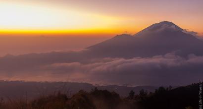
But then the sky began to clear and the horizon lit up with orange light

Clouds hanging in the Batur caldera became visible

And views of the neighboring volcanoes – Abang and Agung – opened up

The slopes of Batur were painted with dawn colors

And we, trying not to shake from the cold, pose in front of the camera

The sun's disk appeared above the sea

Illuminated with its light tourists admiring the sunrise

And an impromptu camp at the top

They say that on ordinary days at this time there is no crowd at the top, but we, in anticipation of good weather, accidentally chose the new moon for the ascent, and on this night, according to some Balinese traditions, it is not customary to climb the Batur volcano, so the people there was very little

The inner caldera is an open semi-ring, about 2 km long. We climbed up at the northern end and decided to walk along it to get down on the other side.

The trail leads along the edge to the opposite peak - exactly where the majority of tourists climb 
At the top there are not only people, but also vigorous dogs who make daily ascents in the early morning 
View of the caldera, from the other direction 
The sun is already shining with all its might, but it’s not warming yet 
Once again a view of Abang with Agung in the clouds 
This is a site in the eastern part of the caldera that we did not go to. 
Enjoying the views from the top

The edge here is very sharp, it’s better to go from below

Road going into the clouds

And again, two brothers - the volcanoes Abang and Agung, which from here seem almost identical, although they differ in height by 1000 m.

The path through the caldera captures impressive views on both sides

Visible in the distance, and below are traces of eruptions, black volcanic rock

We begin to descend


The large caldera is gradually covered by clouds

And the neighboring volcanoes are almost invisible

The cloud is slowly approaching us

The summit is behind

Sleepers are coming towards you

Lake Batur is visible below


And tourists looking at something in the distance

You can stop here

And drink something hot

Or even have a snack

It's us again :)

And of course, what would we do without hungry monkeys?

They feel as comfortable here as in

One even sits on Sasha’s shoulder

Oh, beauty!

You can continue your descent

Coniferous vegetation appears closer to the foot of the volcano

The area reminded us of Karelia

Low fir trees and rock

It's easy and fresh to breathe here

It's already hot downstairs, you might as well take off your clothes

And here is the transport that brought us to the volcano - Sashin Jimmy

And finally, a general photo

After the volcano, on the recommendation of Lesha Pitalenko, we drove up to the observation deck, which offers stunning views of the Batur volcano

Here we met a Balinese woman selling herring for 3,000 rupees ($0.3) per kilogram - we have never seen anything cheaper. To celebrate, we collected several bags =)

Volcano Batur – how to climb it yourself (map)
In order not to attract the attention of guides, you can drive along the main road without turning towards the parking lot.
About 3 km after the fork, there will be a small road on the left going into the forest

And leading to Pura Tampurhyang Temple

Opposite this turn, on the right there is such a stand

A little further, there will be a right turn to the hot springs

The road leading to Pura Tampurhyang takes about 1 km. You can park not far from this hut, and then walk further (you can ride a bike further).

Update. A couple of years later we repeated the climb to Batur volcano. In principle, everything remained the same, the guides did not interfere with our climb and no one pestered us - the main thing is not to go along the tourist route. We climbed up joyfully and cheerfully =) The only thing is that on the way back we didn’t find the right path and went along another one.
Read more about the new climb to Batur.
You can carefully study the route on the map and try to remember it, but to avoid getting lost, we recommend downloading the ascent track and loading it into any navigation program. To access two files, share this page with your friends on social networks.
- Option No. 1 (track, as well as turn marks, etc.): download
- Option No. 2 (updated version of the route, track only): download
Attention! Climbing Batur on your own has always been risky. And it’s not about the difficulty of the climb, but about the problems that may arise with local guides. And such problems are arising more and more often. Here's a recent story from the Facebook group "Together in Bali":
"It's getting really dangerous on Batur.
Local guides beat Russians with sticks who tried to climb the mountain themselves. Previously, they just shouted and spun the tires, but now it’s like this... This story was just sent in our WhatsApp chat, I think it should be here. Don't try to climb the mountain yourself, take care of yourself. And now the story (copied)
Hello. It all went badly..(we didn’t get anywhere, they practically beat us.. At half 2 we were at a fork where everyone was standing, we were walking, there were there are locals there, they didn’t ask anything, then a local runs towards us with a flashlight, he ran up and started asking questions harshly, we’re in the cold, we’re going to see friends... I fell behind... let’s move on, a guy followed us on a bike... we didn’t even get to the point where to turn, this guy on a bike crossed the road abruptly, and 20 people came out of the bushes, with sticks, screaming and kicking, let’s wave.. like you won’t go further, where are you going? You need a guide... and they stupidly kicked Seryozha, he’s trying to close me, I got hit in the legs... we didn’t climb, we didn’t naturally go further ahead... we- ok, ok, what do you want?
Dude, this is our land, you’re in Bali, you can go there, there, for free, but here you can’t... They asked for 600 thousand for two, but we really didn’t have it with us, it was 460... We even started to bargain - no horseradish.. and a local jumps on me.. well.. even if we had money, after the beating, the mood was ruined, Seryozha flatly refused to even get up for money.. and we walked back..(("
When deciding to go to Batur on your own, be prepared for a possible conflict! You can try to climb on your own, but if confrontation arises from the guides, we recommend not to confront and simply pay for their services, or abandon the climb.
If you are not ready for this, then the easiest way is to book a trip to Batur with a tour. Yes, it will be less adventurous, but you will definitely rise to the top without risks and unnecessary problems.
In July 2015, the Indonesian island of Bali came into the spotlight of the general public. The sky above him was cloudy due to the emission of ash. Thousands of tourists were trapped at the airport. The government evacuated local residents from the natural disaster zone. But they found themselves under a layer of volcanic ash. And several villages located on the slopes of the fire-breathing mountain burned down. Does a similar situation often occur in Bali? This is not uncommon for Indonesia. After all, the archipelago state is included in the so-called fire belt of the Earth. This strip, stretching from Kamchatka to the equator along the Pacific coast, still suffers from the violent tectonic activity of our planet. But Bali is also a popular tourist destination. Wide beaches with white sand, mountains with gurgling streams, crystal waterfalls and lush greenery of the tropical jungle... Add to all this first-class service and well-developed tourist infrastructure. Do travelers to this tropical paradise take a big risk? Read about this in our article.
Explosive Indonesia
Every year, seismologists record about seven thousand earthquakes in this country. The figure is, of course, impressive. But don't let this fact discourage you from traveling to Indonesia. The lion's share of tremors is recorded only by sensitive instruments. But, nevertheless, seismologists vigilantly monitor the activity of the subsurface underground. After all, tremors can be symptoms of a much more dangerous phenomenon - a volcanic eruption. These mountains in Indonesia are truly deadly. Just one precursor to an eruption - the release of sulfur gases - can kill all living things nearby. Columns of smoke cover the entire sky with impenetrable darkness. Hot stones fall - volcanic bombs. And streams of lava flow down, burning everything in its path. There are five hundred volcanoes in Indonesia. But only 128 of them are active, and 65 are considered especially dangerous. Are volcanoes in Bali dangerous and how dangerous? We hasten to assure you that eruptions mainly take place in Sumatra. In the “tropical paradise” beloved by tourists, the situation is not so tense. Although…

Active volcanoes in Bali
To calm down a little, let's remember school science, or more precisely, fifth grade geography. Volcanoes are extinct, dormant and active. Seismologists decide which category a particular mountain belongs to based on the date of the last eruption. Bali is a volcanic island in origin. But not all the mountains on it are potentially dangerous. After all, the island was formed millions of years ago. And if a particular volcano last erupted more than ten thousand years ago, it is called extinct. When he showed activity 3500 years ago, he was recorded as dormant. Now about the situation in Bali. It is believed that there are only two active volcanoes on this island. These are Gugung ("Mountain") Agung and Batur. All other volcanoes in Bali are extinct or dormant. Therefore, you can safely go to this island. The last volcanic eruption in Bali occurred in 2000. This cannot be called a real explosion - Gugung Batur threw out a column of ash three hundred meters high, and that was the end of the matter. But in 1964 there was a real eruption (from the same volcano). The highest point of the island, Gugung Agung, has not been active for a very long time.

Dangerous neighborhood?
Two active volcanoes on one small island are still a bit much, fearful tourists might think. And they will turn out to be wrong. Once you look at the population density around the local volcanoes, your slightest fears will disappear. Small villages can be found even in craters. Farmers are attracted to this neighborhood because the mineral-rich volcanic ash is an excellent fertilizer for the soil. Due to the altitudinal zone, a mild microclimate has developed on the slopes of the mountain, conducive to a good harvest. There are also no problems with watering crops, since short rains often occur on the mountain slopes. Any volcano in Bali is held in high regard by local residents. The temples on the slopes testify to this. And since these structures are ancient, we can conclude that the locals do not consider the proximity to the volcano dangerous. Bali's tourism industry uses these mountains for excursions.
The importance of volcanoes for local residents
In the religion and culture of the Indonesians, the center of the Universe was the mythical Mount Mahameru. This axis of the universe split in half. This is how Agung and Batur arose - volcanoes on the top of which the gods live. All villages in Bali are oriented towards the highest mountain of the island. Residents go to bed with their heads towards Gugung Agung - so that the soul is close to the gods. Legend has it that before the volcanoes appeared, the island was deserted and barren. This is partly true: the ash fertilizes the local soil well. The gods come down to people on major holidays, and then return to the heights. To honor them, temples were built on the slopes of volcanoes. Since Agung is the highest mountain of the island, the Besakih complex is the most revered place of worship. This volcano in Bali is under the patronage of Batara Mahadeva (in local Hinduism, Shiva). Once every hundred years, the ceremony of Eka Dasa Rudra - “cleansing the world from all sins” - is held in the Besakih temple on the slopes of Agung. And this holiday in 1963 turned into a tragedy.

Agung eruption
The world cleansing ceremony was scheduled for the spring of 1963. However, when the Agung volcano woke up in Bali in February, the priests said that the residents had chosen the wrong date for the ritual. They say that Shiva does not want to come down to people on this day and expresses his dissatisfaction with the columns of smoke coming from the crater of the mountain. Volcanologists also agreed with the priests. They warned Indonesian President Sukarno that Agung was showing signs of activity and could erupt. However, he had already invited foreign delegations to the celebration and did not want to postpone the ceremony. On March 18, 1963, the Agung eruption entered its active phase. The crater exploded and lava came down. The Besakih Temple was miraculously not damaged. The lava flow passed only a few meters from the buildings. However, a large number of people died then. Now the top of the volcano resembles a lunar landscape, which tourists come to admire. And local residents still honor Agung. They hang the offerings on a curved bamboo penjor pole, which is shaped like the highest peak of the island.

Gugung Agung
This is the highest stratovolcano in Bali - its peak rises 3142 meters above sea level. It is located in the eastern part of the island. The name Gugung Agung translates as “Great Mountain”. In the entire history of observations, the volcano in Bali has erupted only four times: in 1808, 1821, 1843 and 1963-1964. The last one was the most significant and powerful. Then two thousand people died, lava and mudflows came down. The crimson sunsets that were then observed in Europe were associated, according to some scientists, with the release of large amounts of ash into the atmosphere from the Agung vent. After the eruption, the parameters of the crater also changed. Now it is an oval funnel five hundred meters long and two hundred wide. The volcano showed little activity in the 1980s. In 2000-2001, abnormally hot temperatures in the springs were noticed near Agung. Now the “Great Mountain” is dormant... Under the close attention of volcanologists.

Volcano Batur in Bali
This is the third highest mountain on the island. It is located very close to Agung. For tourists, Batur is a favorite place for climbing. Why? Firstly, height. 1717 meters is not three thousand. The hike itself, if you start it very early in the morning, lasts half a day, and you can relax on the beaches. Secondly, at the foot of Batur there is a lake of the same name, the most picturesque in the area. There are also temples on the slopes of the volcano. One of the tourist attractions of Batur is the jets of hot steam. They make their way out of various crevices of the mountain, reminding careless travelers that the volcano is active. The guides assure that it is quite possible to cook scrambled eggs in the jets of this steam. The last eruption of Batur occurred (in conjunction with Agung) in 1964. After this, the volcano again threw a column of ash three hundred meters into the air in 2000, as a result of which the international airport was closed for several days. Now Batur is quiet. Only jets of steam warn of a hidden threat.
Batukaru
This is the second largest volcano in Bali. Its height is two thousand three hundred and fifty meters. On the slopes of this extinct volcano there is also a temple - Pura Luhur. The road to it leads through a forest with playful monkeys. It is recommended to climb this mountain to take good pictures of the island from a bird's eye view.
Caldera Chatur
When our planet was still young, the volcanoes on it were simply huge. When they erupted, calderas with many independent peaks were formed. This is what Chatur is now - a ridge of volcanoes stretching for eleven kilometers. Excursions go to Sengayang, Pohan, Lesung and Pengilingan, as this region is famous for its thermal springs. There are also beautiful lakes there - Bratan, Tamblingan and Buyan. To the southwest of Chatur stands Batukaru, the second highest volcano in Bali.

What happened in the summer of 2015
On June 3rd, news arrived that the skies over Bali airport were closed. Since the island is a popular tourist destination, the news caused a stir. Has there really been a new volcanic eruption in Bali? Batur has been sleeping since 1964, and so has Agung. What happened? In fact, the seismological situation has worsened in Java and Sumatra. He made some noise. He woke up in early 2014, killing sixteen people. The mountain is located in the north of Sumatra. In the summer of this year, Sinabung threw volcanic ash into the sky. Columns of thick smoke reached a height of two thousand meters, temporarily making air travel impossible. In July, two more volcanoes woke up in Java - Gamalama and Raung. Nine hundred flights were canceled because of them.
Tourist attraction or serious risk?
So should you be afraid of volcanoes in Bali? As the reviews of tourists, and the measured and calm life of the islanders themselves show, there is no reason for concern. Volcanoes do not wake up instantly and unexpectedly. Their eruption is preceded by various phenomena, such as an increase in the temperature of the sources and the release of gases. A volcano on the island of Bali such as Batur is especially attractive to tourists.
Volcanoes in Bali are three peaks located in the central and eastern parts of the island. Two of them are active. There are also several dozen extinct and sleeping ones. They form a large mountain range in the central part of the island. The mountains in Bali are sacred and play an important role in the religious practices of the locals. In recent decades, the peaks have become popular among tourists.
You can learn more about them by clicking on one of the names below. And in this article I want to talk about the general characteristics of all the mountains and volcanoes of the island, as well as why they may be interesting.
The island's attractions are very diverse. There are ancient temples, beautiful natural parks, rivers with waterfalls, beaches, and much more. On the site, all interesting places are divided into categories. You are currently in the "Mountains and Volcanoes" category. To find out about other attractions, go to the “Places by Category” section and click the button with the desired name. You can see the full list of objects by clicking the “All places” button.
Description of volcanoes and mountains
The island of Bali, like all of Indonesia, is part of the huge Pacific Ring of Fire. It is located at the point of contact between oceanic, island and continental lithospheric plates. The ring stretches from New Zealand, through Oceania, the east coast of Asia, Kamchatka, the Aleutian Islands and the west coast of North and South America. The belt is interrupted only off the coast of Antarctica, near the state of California in the USA and Vancouver in Canada.
.jpg)
In the region of the largest ocean on Earth there are three ocean plates - the Pacific itself and two small ones - Nazca and Cocos. The Indo-Australian, Philippine and Eurasian plates are also adjacent here. Oceanic plates gradually subduct under continental or island plates, since their density is higher. Sometimes it even sinks into the earth's mantle. This phenomenon is called subduction. It leads to the formation of active volcanoes where lithospheric plates interact, and earthquakes constantly occur here. Thus, 75% of all active volcanoes on our planet are located in the Pacific Belt of Fire and almost 90% of earthquakes are recorded.
.jpg)
.jpg)
Bali is located in the subduction zone of the Indo-Australian and Pacific plates under the Sunda plate (part of the Eurasian plate). At the bottom of the ocean, at the junction of lithospheric plates, the Sunda or Java Trench is formed with high seismic and volcanic activity. The geological age of the Bali mountains is relatively young (approximately 200-500 million years, some mountains were formed 20 million years ago). They belong to the Paleozoic, Mesozoic era, Neogene and Quaternary periods.
Now I will tell you about the volcanoes and mountains themselves.
General characteristics of mountains and volcanoes
The mountain range stretches from west to east, dividing the island into northern and southern parts, and significantly influences the climate. In the northern half it is dry, in the southern half it is wet. That is why there are more rivers in the south and agriculture associated with rice cultivation and irrigation is developed. It is much colder in the mountains than on the plains. There is a lot of precipitation here and there are dense fogs. If you are going on an excursion to mountainous areas, bring warm clothes.
.jpg)
.jpg)
.jpg)
.jpg)
.jpg)
.jpg)
All mountains and volcanoes on the island can be characterized by the following parameters:
- By height
- On infrastructure development
1. Height
Here we can roughly distinguish three types:
- More than 2,000 meters – 7 peaks
- More than 1,000 meters, but less than 2,000 meters – 22 peaks
- Less than 1,000 meters - the exact number is unknown, since this definition includes small hills and elevations that are difficult to count
All active volcanoes in Bali are over 1,000 meters high; the tallest of them is , its height is 3,142 meters. , which is located in the caldera of the Bratan volcano, is the second highest (2276 meters). occupies only 13th place among all peaks, its height is 1717 meters. On the edge of its caldera there is another peak, Abang. It is part of an old large volcano. The height of Abang is 215 2 meters.
.jpg)
.jpg)
.jpg)
2. Infrastructure:
- Absent
Such peaks are rarely visited by tourists. Their slopes are overgrown with forest, there are almost no paths or they are difficult to climb. On the top or slope there may be small temples or altars, often dilapidated and rarely visited.
.jpg)
.jpg)
.jpg)
.jpg)
.jpg)
- Poorly developed infrastructure
Most often such mountains are found in the north of the island. Near their foot there are always 1-2 villages, at the top there is a small temple. Sometimes on the slopes you can see rice terraces, coffee plantations, and orchards. There are narrow roads and hiking trails, but the entire infrastructure is designed exclusively for local residents.
.jpg)
.jpg)
.jpg)
.jpg)
.jpg)
- Well developed infrastructure
These are popular peaks among tourists, which are regularly climbed. There are well developed routes here. Near the foot you can find parking lots, cafes, restaurants, and hotels. Local guides offer guiding services. Also included in this category are mountains with large rice terraces and plantations. The infrastructure is also well developed near the large mountain temples, where pilgrims come from all over the island.
.jpg)
.jpg)
.jpg)
.jpg)
.jpg)
.jpg)
.jpg)
.jpg)
.jpg)
Specific characteristics of volcanoes
Almost all the mountains on the island were once volcanoes or formed on the slopes of calderas.
Now there are officially three real volcanoes:
- Bro
There are some characteristics that can be attributed exclusively to volcanoes. All of them belong to the central type. This means that in the middle of the mountain there is a trench about 20 km deep (this is exactly the thickness of the lithospheric plate in this region). The lower part of the volcanic vent reaches the earth's mantle with magma, the upper part ends with an expansion - a crater. Some volcanoes may form additional craters.
Volcanoes can be classified according to the following criteria:
- By activity
- By shape
- By number of craters
- By type of post-volcanic phenomena
Below are detailed characteristics of volcanoes for each category.
1. By activity
- Active - erupted within the last 3500 years
- Dormant – eruptions occurred between 35,00 and 10,000 years
- Extinct - have not erupted for more than 10,000 years
As I already said, there are two active volcanoes on the island - and. They are located in the province of Kintamani on the east coast. The last eruption of Agung was recorded in 1963. Batur has been active three times in the last 100 years - in 1917, 1963 and 2000. The most destructive eruption occurred in 1917. The last activity of the volcano began in 2017. Read more about this in the section Volcano Agung - news.
The third volcano, Bratan, is considered extinct; the date of its last eruption is unknown. Most likely, it was several thousand years ago.
2. According to the form
- Stratovolcanoes
- Calderas
The stratovolcano is formed as a result of periodic eruptions; lava, ash and hot slag are deposited in layers on its slopes. The crater at the stratovolcano resembles a funnel with concave edges. Sometimes lava flows out of side cracks, and after it hardens, specific stone corridors are formed on the volcano.
A caldera is a negative landform. It is formed after multiple volcanic eruptions over a short period. Under its base, voids appear into which part of the earth's surface falls. Often part of the caldera fills with water, forming lakes. Calderas can be seen near the Batur and Bratan volcanoes. Moreover, the Batur caldera is considered one of the largest in the world.
.jpg)
.jpg)
3. By the number of craters
- With one crater
- With several craters
Mount Agung has one crater. And Batur has three. Bratan Volcano is a huge caldera, along the edge of which there are several peaks with the remains of old craters.
.jpg)
.jpg)
4. By type of post-volcanic phenomena
- With fumaroles
- With hot springs
Fumaroles are small cracks on the slopes of a volcano from which steam and gases escape. You can see them on Batur. The steam temperature is so high that you can easily cook food in them. There are hot springs in the Bratana caldera and near Batur.
Volcanoes largely determine the island's topography and soil composition. Thanks to their activities, lakes appeared here, fertile land that can produce 3-4 crops per year. Even the black and gray color of the sand on the beaches is associated with eruptions and emissions of volcanic ash.
.jpg)
Volcanoes and mountains on the map
RU. The gods split it into two peaks - and. Since that time, the island has turned from a desert into a fertile land suitable for human life. In part, this statement has its own logic, because, thanks to volcanic ash, the local soil became suitable for agriculture.The Balinese believe that gods live on the mountain tops and come down to earth on major holidays. The most revered peak is Agung; on its slopes there is the sacred complex of Pura Besakih - “Mother of all temples”. The patron of the shrine is Shiva (in the Balinese version, Batara Mehadeva), personifying the masculine principle. There is also a temple near Batur, it is dedicated to the water goddess Devi Danu. In addition, there are small temples of local significance on almost every mountain.
.jpg)
.jpg)
.jpg)
For tourists, the volcanoes of Bali, like the local mountains, are, first of all, interesting and exciting climbing routes. Particularly beautiful views open from the peaks at dawn, when the first rays of the sun illuminate the island. The most popular routes among travelers are the routes to the craters and. In articles about these volcanoes you can get to know them in more detail.
Batur is an active volcano in Bali, which is located in the northeast of the island. Batur is one of the most interesting places on the island, because firstly, it is not just a mountain, but a volcano, and secondly, it is an active volcano. The height of the volcano is 1717 meters, its last eruption was in 1964, and the last emission of ash to a height of about 300 meters was in 2000. Batur is also very attractive to tourists because you can climb it in just a couple of hours, and not like the neighboring Agung volcano, which takes 6-7 hours to climb. Many people want to test themselves and see if they can rise to such a height on their own. In fact, this is not the most difficult climb, because the volcano is not very high and you only need to walk about 3 kilometers along a well-trodden path. Most often they climb Batur at night to see the stunningly beautiful sunrise above the clouds. We also decided to test ourselves, since we had never climbed any mountain before, let alone a volcano, an active volcano :)
There are 2 ways to get to Batur Volcano - on your own by moped or car, or in an excursion group. We got there on our own on a moped; the road from Kuta from our Bliss Surfer Hotel took us about 4 hours. We drove at night through Ubud to meet the guys with whom we planned the sunrise to Batur. The road was not difficult, but I advise everyone to get a good night’s sleep the day before, you won’t sleep all night and you will need strength to first get to the Batur volcano, climb it, descend and then get back to your hotel on the coast. Especially on the way back you may feel very sleepy. After the Batur volcano, the whole company went to the waterfall, which is located not far from Batur. And we spent the whole day on our feet, so much so that when we were driving back to Kuta I fell asleep on the moped a couple of times :) 
Guides on the Batur volcano
You might think that you can easily get to the volcano on your own and climb it on your own, since you just need to follow the tourists along the road to the top, it seems like nothing complicated, right? And here a key point arises, which has recently been often discussed on forums about Bali - these are guides at the foot of the Batur volcano. They will not allow you to calmly pass and begin to climb the volcano. They will demand that you pay for a guide and convince you that you simply need a guide! If you reject their offers, they will tell you more persistently that without a guide, in principle, it is impossible to go to the top of the Batur volcano. Due to the fact that the passage to the volcano itself is free, you will wonder why you need a guide for money if you can climb the path to the volcano on your own. Further threats may follow, consisting in the fact that you leave your vehicle in which you arrived in the parking lot, and that it will be unguarded, hinting that they can puncture your tires and stuff like that. There are known cases when so-called guides even beat tourists when they did not agree to their services. If, after all the threats, you decide that you are ready to pay 350,000 rupees for a guide for 4 people, then be prepared for the fact that at this moment they can tell you a completely different price - 4.5 times or more. Here you have to either agree to this price or cancel the climb to Batur volcano. We ended up having a clash with the locals, but I will write about this in more detail below.

Our story of climbing Mount Batur
Julia found on an Internet forum an invitation from our, in the near future, good friend Diana to join the climb to Batur. And this was a very tempting offer, because this volcano is active, firstly, and is much easier to pronounce than some Icelandic Eyjafjallajökull.
We agreed to meet with Oleg and Diana in Ubud at one in the morning. In Ubud we met Oleg and Diana, who lived in a wonderful place not far from (Monkey forest), soon Varya and Seryozha from Nusa Dua, Katya from Sanur and Nastya from Kuta joined us. We just had to wait for Seryoga, who agreed to take us on a short route, because he went to Batur in a jeep a couple of times during the day. Soon our new comrade arrived and the nine of us rushed to the northeast.

By the way, windbreakers or warm sweaters will be very useful; at night in the mountains it is quite cool, and on a bike you can really feel it.
Almost everyone’s bikes were only half full, so it was very nice to find bottled gasoline at 3 a.m. from one of the few Balinese women who was awake that night. Seryoga suggested taking us not along the standard route that all tourists take, but bypassing them, on the other side of the volcano.
Seryoga, guided by the stars, flew through both turns indicated on the map, and after consulting, we decided to return, trusting the navigator, and Seryoga and Nastya turned right away and turned out to be absolutely right, as the course of history showed, and the rest, returning to the first turn, following Google’s route, descended to the guides' station. Since their appearance did not inspire much confidence, we spoke only Russian among ourselves and decided to go further to the point designated as the ascent point.
Yes, of course, we read what could happen next and were even ready. As it turns out, the locals know how to do shows quite well. About 30 people rushed after us on bikes and, with a squeal, either overtaking or letting us go ahead, accompanied us.

Once we reached the launch pad, we parked and the action began.
We were surrounded by locals and questions began about why we had come, whether we wanted to go to the mountain, whether we needed a guide.
This is a normal situation for an Asian country, a start has been made, we decided to bargain, I’ll say right away that we were ready to offer a maximum of 100 thousand per person.
An Indonesian in a red bandana, playing the role of an alpha male in the play, goes to the center of the clearing, throws a coil of rope and declares that he hangs tourists here every day))
But since nothing was found on the local palm trees except coconuts, he began bargaining with him, he immediately stated that he did not like Russians because they were criminals and preferred Americans, Germans, Dutch, Australians because they were good people (and did not bargain Looks like) 350 per person or turn around and go home.
In general, their minimum price tag is 350 per guide for a group of 4 people, and we knew about this, but they did not reduce the price. 
I tried to talk friendly, joke, saying that we were students, that I was not a criminal Russian, and that I was not a Serb at all. After 10 minutes, he set the conditions - either we agree to his conditions, or we quit. I tried to pull others aside, but they refused to talk.
Then they started pushing us towards the bikes, so we decided to return to the guides’ parking lot.
In the parking lot, Oleg and I decided to go to the guides office and try to reduce the price one last time. We were shown a price list where it was written in normal English that 350 had to be paid for a guide, but the local stated the price per person. The time was approaching 5, we were flying past the dawn over Batur, we had to look for another option. Diana phoned Seryoga. As it turned out, he successfully reached the ascent point on the other side of the volcano and successfully climbed up with Nastya, discussing the features of the starry sky of the southern hemisphere. And we decide to go there.
We are about to leave, our night interlocutor comes up to us and again asks a binary question that we have 2 answer options, either yes or no.
I say that in fact he has 2 possible answers - either he agrees for 700 or not. He slows down for a minute, then says no and we leave.

Someday later, when I am big and fat, with a gray beard and no longer allowed to leave Russia, I will write what I thought at that moment about this standard gopov’s scam, about the colonial policy of Holland in this country and about the influence of money on the fragile minds of local peasants. In the meantime, this is not entirely correct, and except for this situation, Bali makes you fall in love completely, so we flew to the new location in 20 minutes on bikes. True, on the way, on a serpentine road, Katya’s bike’s brakes failed. We decided to throw it into the bushes and resolve the situation upon our return.
In the local warung they found a guy who agreed to become a guide. Since there was little time, we didn’t bargain much and agreed on a price of 500 for the whole group. The climb from this side of the volcano is much longer, it can take about 3 hours and is physically difficult... mmm, we are Russian, so there were no alternatives discussed.
The guide turned out to be a very nice guy. He was born in this area, worked all his life in the warung and considers it his life's mission to sell coffee and cigarettes to passing truck drivers hauling sand in the quarries. On the track, he led the group at a leisurely pace.
 The climb turned out to be difficult, and when we got to the site where Seryoga and Nastya were located, we were very seriously exhausted. Katya immediately fell asleep, and the rest scattered in search of sights or simply relaxed, enjoying the stunning view.


This includes Lake Batur, the neighboring mountains, villages scattered on the slopes and a sea of greenery. All around, hot steams were escaping from the rock crevices, enough to boil eggs or tea.

When the first rays of the sun illuminated the valley, everyone perked up, took a couple of hundred photos, jumped and headed back.

And since it is much easier to go down, the mood was excellent and I interpreted this trip as a free retelling of Little Red Riding Hood, where the heroine also initially chose the wrong road. It was only 9 am, so it was decided to continue the walk and we all went to the waterfall together.

On our next trip to the island of Bali, we climbed another volcano - which is located on the neighboring island of Java, but more on that in the next article :)
 What conclusions can I draw after this story? To be honest, I was very upset that we still didn’t climb Batur at night and didn’t see the dawn through the clouds. Personally, I, Yulia, was ready to pay the money that the guides asked from us, and even better, we had to buy a guided excursion to the volcano at a travel agency in advance. Initially, we planned this, but then we found a company and decided that it would be more fun this way. Yes, it was fun, but the original goal was not achieved. At the same time, a volcano is not a place where you can come and try to climb again in a day or a couple of days; it is not a beach. I realized that we would climb the volcano now or never. Therefore, of course, I was extremely upset that everything didn’t work out the way we planned. That's why I recommend in advance