What is the name of the highest peak in Georgia. Mountain peaks of Georgia
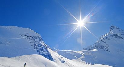
Mountains! They delight, fascinate and remain in your heart forever. Once you see them, you can’t help but return to them, and the memories of them give you goosebumps. We couldn’t ignore the topic of mountains, so we remembered the TOP 7 highest mountains of Georgia, which has always been famous for its beautiful peaks with hard-to-reach routes.
Shkhara - height 5,193.2 meters
Many believe that the highest mountain in Georgia is Kazbek, however, in fact it is Shkhara, covered with eternal snow, in the Svaneti region. Shkhara has many peaks, apparently because of this its name is translated as “striped”: several parallel ridges descend into the valley, forming something like stripes. The main peak was first conquered by Soviet climbers in 1933, but now tours are organized on the mountain even for beginners. At the foot of the southern slope is the high-mountain community of Ushguli, consisting of 4 villages: Zhibiani, Chazhashi, Cheibiani, Murkmeli. This village, after the village of Kurush, is considered the highest in Europe and is included in the UNESCO World Heritage List.
Kazbek or Mkinvartsveri - height 5,033.8 meters
“Mountain with an icy peak” - this is how the name Kazbek is translated from Georgian. Kazbek is located in the picturesque region of the Central Caucasus on the border of Georgia and Russia. The harsh region with the whiteness of snow-capped peaks is a tasty morsel for climbers from different countries. In fact, Kazbek is a dormant volcano, as evidenced by the frozen lava flows visible on its slopes, descending into the famous Daryal Gorge. And at an altitude of 3800 meters in a cave there is an ancient Georgian monastery Betlemi (Bethlehem).
Ushba - height 4,690 meters
The majestic double-headed peak rightfully reigns over the entire line of the Caucasus ridge. This is a real queen! Tall, slender and... inaccessible. Due to difficult and unstable weather conditions and a steep profile, the peak is considered one of the most difficult to climb among the Caucasus ranges and can only be climbed by experienced climbers. The name Ushba is translated from the Svan language as “mountain that brings troubles.” And indeed: this mountain caused the death of many climbers who wanted to conquer it.
Tetnuldi - height 4,869 meters
Mount Tetnuldi (translated as “White Mountain”) is located in picturesque Upper Svaneti, just 20 km from the village of Mestia. The mountain above is always shrouded in fog, and in connection with this, people came up with an interesting legend: the queen - Mount Ushba - fell in love with Tetnuldi, and he, being very shy, constantly hides from her. The fog is a veil under which Tetnuldi hides his face from Ushba. In this picturesque place, one of the largest ski resorts in Svaneti, the Tetnuldi resort, opened at the beginning of 2016.
Diklosmta - height 4,285 meters
“Mta” in Georgian means “mountain”, “Diklo” is the name of the oldest village of Tusheti, from the vicinity of which Diklosmta is clearly visible. This mountain serves as a natural border between Dagestan, Chechnya and Georgia. Its passes are very difficult to pass: Diklosmta is very icy. In this regard, nine large glaciers are concentrated here, the most powerful of which, the Diklos glacier, is located on the northern slope and serves as the main source of nutrition for the Khulandoy River.
Banguriani - height 3,838 meters
Another one of the most beautiful sights in Georgia is Mount Banguriani. It is located in the village of Mestia in the Samegrelo Zemo-Svaneti region. Every year more and more climbers conquer it, and it is worth noting that Banguriani was the first peak conquered by the “Tiger of the Rocks” - the famous Georgian climber Mikhail Khergiani. The windows of his home overlooked Banguriani, and it forever remained his favorite mountain.
Shoda - height 3,609 meters
Mount Shoda belongs to the Main Caucasus mountain range and is loved by many tourists. We can say that it is a kind of separator between the borders of Georgia and Russia. If you manage to conquer it, you will be guaranteed a stunning panoramic view of the picturesque area. The main local treasure is rock crystal, and alpine and subalpine plants grow at an altitude of 1900–2000 meters.
December 12th, 2013
All around rose the grandiose Caucasian mountain range. The village, sandwiched in a narrow gorge between the mountains, was illuminated by the first rays of the morning sun. At the end of May the grass was covered with dew and the fruit trees were in bloom. Here, in a high-mountain village at the foot of the highest mountain in Georgia, I felt the power of the Greater Caucasus. One morning near Mount Kazbek, a walk through the village of Gergeti with its stone houses and tiled roofs, a steep climb up the mountain to the Trinity Church - this short time in the mountains was one of the most memorable stages of my Pan-Caucasian journey.
My morning started in Stepantsminda. Stepantsminda turned out to be a small town, even a village, stretched in the valley of the Terek River along the Georgian Military Road. Eleven kilometers separate Stepantsminda from the village of Verkhniy Lars in the Daryal Gorge on the Russian/North Ossetian border, where a new tunnel and checkpoint was recently opened.
The valley of the Terek River, where the village of Stepantsminda is located on both sides of the river, stretches from north to south, and from the east and west the valley is limited by two powerful mountain ranges. Exposed rocks rise more than 1000 meters above the roofs of small houses scattered along the bottom of the gorge. From the east, the gorge along the Terek River is framed by the rocky slopes of one of the East Caucasus ranges. The highest point of this mountain range (Shan Mountain, 4451 m) is located on the territory of Ingushetia. Somewhere here, at an undetermined altitude, there is a physically insurmountable border with Ingushetia.
To the west of the valley, Mount Kazbek, the third highest point in Georgia and the seventh highest peak in the Caucasus, casts a shadow over Stepantsminda. Located east of the Rioni River, which divides Europe and Asia, Kazbek is often not included in the list of the highest mountains in Europe. 5033 meters (" and 80 centimeters“, whisper the pedants) and an absolute elevation of 2500 meters above the surrounding mountains. Kazbek is a mighty mountain, forever covered with snow and ice.
Geologists have proven that the five-thousander Kazbek is an extinct volcano. Scientists claim that the last eruption occurred in 650 BC, long before the emergence of the first Georgian state. New eruptions are not excluded. Minor earthquakes occur at regular intervals in the Kazbek region.
One might expect that Georgia's highest mountain itself is called " white mountain" or " mountain of the gods“, but, in fact, Kazbek got its name in honor of a small appanage prince, who owned the village of Stepantsminda (formerly Kazbegi) at the foot of the mountain. The trade route to Russia passed through the village of Kazbegi, and the first travelers in the 19th century, who laid the Georgian Military Road, transferred the name of the village to the highest mountain in Georgia. And Kazbek, although high, is not the highest peak in Georgia.
The village of Stepantsminda is very close to Russia. The Russian border service controls the passage between North Ossetia and Georgia. From the North Ossetian capital of Vladikavkaz, the peak of Kazbek is visible in clear weather, but in Stepantsminda itself there is no proximity to Russia, Ossetia, Ingushetia, Chechnya and the self-proclaimed South Ossetia. If you don’t think about the fact that a few kilometers to the north there are some of the most unstable regions of Europe (after all, this is still Europe!), then the rest of the idle tourist will not be disrupted.
Eastern wall of the Terek River valley. Below lies the village of Stepantsminda.
People come to Stepantsminda to see the sparkling white Kazbek, like in an advertisement for washing powder, and to indulge in high-calorie dishes of Georgian cuisine with a sporty climb up the mountain to the Gergeti Trinity Church. The most adventurous athletes go on a two-day mountaineering trip to conquer an extinct prehistoric volcano through the permafrost zone.
Good visibility at the top is only available in the first half of the day. After lunch, humidity usually collects on the mountain slopes, and the top of Kazbek is hidden by clouds.
The journey to the top of Kazbek (5033 meters) through eternal snow takes two days. In total, the climber overcomes a height difference of 2500 meters. At the end of the first day, the climber reaches an alpine hut, a former meteorological station at an altitude of 3675 meters. Here climbers spend the first night to adapt to the thin air.
On the second day the ascent continues. In the zone of eternal snow at an altitude of 4100 meters there is an amazing cave monastery of Betlemi with rock icons. For a long time, stories about the cave monastery were considered folklore. It was reported that only a person with a sinless soul and pure thoughts can find the cave. In 1948, a scientific expedition, while climbing Kazbek, found a metal chain fastening on one of the rocks (as reported in the myth) and, near the fastening, a group of scientists discovered a heavy cast-iron door (how can a heavy door get into a height of four kilometers?). Hidden inside was a once active cave church with untouched icons, candlesticks, ritual bowls, a small treasure of coins and other church paraphernalia. Betlemi Cave lies along the route of one of the routes to climb Kazbek.
View from the mountain near the Trinity Church to the west (Mount Kazbek) and east (Mount Shan).
If you leave ambitions about the conquest of Kazbek and planting a family coat of arms on its top aside, and skip the trip to the museum of Alexander Kazbegi (the most famous native of the village), then half a day will be enough to visit Stepantsminda. The minimum program includes the ascent to the Gergeti Church, known from numerous postcards and covers of guidebooks.
Gergetis Tsminda Sameba is a typical medieval Georgian church made of red stone, with a spire-shaped dome against the backdrop of smoky mountains. Often under this view there is a caption as if the church was photographed against the backdrop of Mount Kazbek. This is a blatant lie: the Gergeti Church, as a rule, is photographed against the backdrop of a mountain range framing the narrow valley of the Terek River on the opposite side from Kazbek. The background is created by rocky mountains and the highest point of the mountain range, Mount Shan, 4451 m. If you look at the Gergeti Church towards Kazbek, the church is barely visible from the valley. So, let's start hiking up the mountain. Our goal is the Gergeti Trinity Church.
Early rise, morning, dew on the blossoming apple trees. Even at the end of May it is still cool in Stepantsminda. The mountain valley at an altitude of 1740 meters has a mountain climate with late summer.
Camping breakfast " Snickers"and a bottle of yogurt on the way from Stepantsminda to the village of Gergeti. The Gergeti Trinity Church is named after the village close to which it is located. The village of Gergeti lies at the foot of the mountain. This is a real mountain village, consisting of two well-trodden streets and one T-shaped intersection, one- and two-story houses with - occasionally - tiled roofs and stone walls. Goats roam between the houses, and horses graze in the meadows above the village. Traditional picture from the Caucasus.
Peasant life in Stepantsminda and Gergeti.
Having passed Gergeti, you need to turn off the road at the place indicated in the guidebook, crawl under the barbed wire stretched low between the rickety posts on the slope, and begin climbing the mountain along a folk path hidden in the forest.
It's amazing how accurate the guide is Lonely Planet describes the route to the church. Using such uncertain variables as the bend of a gas pipe in the courtyard of the third house from the end of the street on the left, a stream that washes out the path in one place so that you have to jump over a mud puddle, the fourth turn of the serpentine clockwise, the guidebook surprisingly accurately describes the route up the mountain. Climbing the mountain takes about 40 minutes and burns a lot of calories.
Tired or lazy travelers who want to post a photo of the Gergeti Church for a rating on LiveJournal, but are not ready to get their jeans dirty, can buy a tour at " field» with a local guide. The jeep will take you up the mountain and stop exactly in the very place from where the traditional shot of the church is taken against the backdrop of gray, smoky mountains.
At the same time, behind the scenes there is a photograph of a jeep parking lot on a trampled meadow and a group of two bright blue dry closets against the backdrop of Kazbek. For some reason, it is not customary to bring evidence of mass tourism home from vacation. Each of us wants to create the illusion of exclusivity and pioneering when it comes to vacations.
It is precisely because of tourists in jeeps that the approach to the Gergeti Church resembles a mudslide: cars unceremoniously cross a high-mountain clearing and drive up to the church itself, so that tired European tourists can effortlessly check in at the church, which was built at the cost of human lives in one of the most inaccessible corners Georgia in the 14th century.
It is not for nothing that the place for the construction of the church was chosen so far from civilization. At an altitude of 2170 meters, the Tsminda Sameba Church was located so inaccessible that for some time at the end of the 18th century, the Georgian national relic - the cross of St. Nina - was hidden here. The history of the cross, which changed its owner many times due to various gifts, thefts and indulgences of emperors, and was kept for a long time first in Armenia and later in Russia, deserves a separate story in itself. Once on its intricate path, the cross of St. Nina was kept here, in the Gergeti Trinity Church, in the heart of the Greater Caucasus, among snow-capped mountains and green meadows.
All the way to the top of the mountain, my friend and I were accompanied by two stray dogs. They followed us back in Stepantsminda and walked with us all the way to the Gergeti Church. They ran, jumped, chased butterflies, scratched themselves, but all the time they accompanied us to the church. Sometimes, when we couldn’t figure out where to go next, the dogs showed us the way. The four of us reached Trinity Church.
Me and the dogs against the backdrop of the eastern wall of the Terek valley. Photo grishasergei
"I.
We learned that good people are led to the top of the mountain by good spirits in the flesh of dogs only after returning to Stepantsminda. When I stood on the church wall and admired Mount Kazbek through the lens, the dog jumped off the fence and disappeared. I didn't see him again. We went back to the village without being accompanied by good spirits.
The dog brought me and my friend to the church, after which his role was fulfilled, and the mysterious good spirit disappeared.
After a hasty lunch of barbecue, we jumped on a minibus to Tbilisi. Four Polish friends were sitting in the gallery, and next to the driver was a lonely Korean woman we knew from the hostel in Yerevan. Half " gazelles"There were foreigners.
The most dangerous hero of the Georgian road is the minibus driver. The minibus driver pressed the gas pedal to the floor and did not slow down until the Didube bus station in Tbilisi. Somewhere in the middle of the road I woke up from the terrible roar of a motor. " Gazelle" rushed along the oncoming lane at a speed of at least 140 km/h. My friend and I looked at each other. I tried to calm down and go back to sleep. We reached Tbilisi in two hours - twice as fast as in a jeep with an Ossetian mafia, when we drove along the same road the day before in the opposite direction.
The good spirits in the form of two dogs disappeared as soon as the goal of the mountain route was achieved, but during the trip they accompanied us again and again, appearing from time to time in different guises: once in the person of a school bus driver who picked us up after many hours of voting on a deserted road to Adygen; sometimes in the person of a grandmother who prepared amazing Georgian breakfasts in a Borjomi apartment; another time - when I observed a thunderstorm developing over the Black Sea on one of the last days in Georgia. New adventures awaited me ahead, and that same evening I went to Borjomi.
More reports about , and individual cities along the route - follow the links!
Those who want to conquer inaccessible peaks, improve their health and have fun.
Where are the mountains located in Georgia?
In order to answer questions about whether there are mountains in the country, what their names are and where you can go to, look at the map of Georgia, where you can see that most of the hills are located on the border with Russia, as well as with Abkhazia, South and North Ossetia. By the way, some peaks are located in the central part of the state, for example,.
You can come to the country at any time of the year; each season is good in its own way. Holidays in the mountains of Georgia in the summer in 2018 will be ideal, since the snow has already melted, although at an altitude of more than 2500 m it can occasionally occur. The air does not warm up much, so it will be comfortable to be here, but at night it can even be cold. By the way, in August berries and fruits are already ripening, which is considered an additional “bonus”.
If you decide to travel through the mountains of Georgia in the fall, be prepared for the fact that the roads may be damaged by rain, and snow often falls in November. In winter it is worth visiting, which are ideal for freeride. In the spring it is better to come here for May, however, you need to be prepared for cold evenings.

If you decide to spend an unforgettable vacation, then go hiking in the mountains of Georgia, where historical mountains are located, about which myths and legends tell. The cost of the tour depends on the complexity and duration of the route. Regular, for example, always costs less than climbing. Very often tourists are interested in the question of what is the highest mountain in Georgia, what is its name and where is it located. It is considered the largest peak in the country, and in terms of its size it ranks 3rd in the Caucasus and in Russia.
On the border with Ossetia there are the most beautiful mountains in Georgia, in particular, photos of them can be seen in the country, and on the slopes there are places for, which provide conditions for a comfortable overnight stay. Tourists will be able to take advantage of all the benefits of civilization, including the Internet.

The most famous mountains of Georgia
There are a large number of peaks on the territory of the country, some are extinct, others are, however, each of them has a special charm. The most interesting mountains in Georgia are:
- – it is located in the Semegrelo region of Zemi Svaneti and belongs to the Southern spur of the Bezengi wall. Its peak reaches 4969 m above sea level: to get here you will need mountaineering experience. Currently under construction here, the route of which will be the largest in the Caucasus, its length will be 9.5 km.
- - a mountain in Georgia, which is also called Mkinvartsveri. In terms of size, it ranks second in the country and is a stratovolcano that went extinct in 650 BC. It's quite difficult to get up here, but it's worth it. Along the way you will see where an ancient monastery called. In the old days, church treasures and shrines were kept in it.
- is the largest mountain in Georgia, located in the region and is part of the Bezengi Wall. It reaches a height of 5193 m; its peak was first conquered by Soviet climbers in 1933. At the foot of Shkhara there is a unique settlement included in the UNESCO World Heritage List.
- - one of the most famous mountains of Georgia, located in the region of Samegrelo - Upper Svaneti. Its name means “misfortune” in the local language, because it was here that a huge number of climbers died who wanted to conquer the peak. The top of the rock is located at a distance of 4690 m above sea level.
- - a mountain in Georgia, where the popular tourist resort of Gudauri is located, as well as architectural and natural attractions. In the old days, its peak was conquered by such famous writers as M. Lermontov, A. Pushkin, A. Dumas, V. Mayakovsky and A. Griboedov.
- – Holy Mountain in Georgia, named so by analogy with Mount Athos. It attracts tourists with its places of worship, the Temple of Father David and its natural origin. There are places here that offer a wonderful view of the city. You can climb to the top by cable car or on foot.
- - a mountain in Georgia, the name of which is translated from Georgian as “Great Abul”. It is part of the Lesser Caucasus system, reaches a height of 3189 m above sea level and is an extinct volcano, composed mainly of Neogene hyalodacites. The slopes are covered with alpine meadows with small and moraine ridges.
- – this mountain range is located on the crest of the Snowy Range in the eastern part of the Greater Caucasus and is the natural border between Georgia, Dagestan and Chechnya. Its peak is located at an altitude of 4285 m above sea level, and on the northern slope the construction of the Veduchi resort is underway.
- - this is the favorite mountain of the famous Georgian climber, who is called the “tiger of the rocks”. It is located in the Samegrelo Zemo-Svaneti region and reaches a height of 3838 m.
- – the mountain is located in the eastern part of the Main Caucasus Range where the border of the Republic of Ingushetia and the municipality of Dusheti passes. The peak is located at an altitude of 4275 m above sea level, the slopes are composed of Jurassic clay shales and are covered with vegetation characteristic of the nival-glacial zone.
- – belongs to the Pshav-Khevsuret ridge of the Main Caucasus Range and reaches a height of 3294 m above sea level. The Alazani and Iori, as well as various tributaries, originate here. The mountain consists of eruptive and sedimentary rocks; at its foot lies the Iori Plateau and the Alazan-Avtoran Valley.
- – located between the peaks of Free Spain and the Caucasus, 4 glaciers originate from the slopes of the peak: Kashkatash, Bzheduh, Lekhzyr and Chalaat. The name of the mountain is translated from the Adyghe language as “stole the horn.”
- - a mountain covered with a glacier. It is located between the Adylsu and Bashkar peaks on the border with Russia and is considered one of the representative and key for scientific research; observations have been carried out for more than 50 years. The mountain is the extreme one in the Adylsu gorge.
- – located on the Main Caucasus Range on the border of Georgia and Kabardino-Balkaria, in the upper reaches of the Chegem River. The height of the mountain is 4611 m above sea level, and it itself is composed of crystalline schists, granites, and gneisses. It was first conquered by climbers L. Gutmanov and N. Popov in 1935. The sources of most large glaciers are located here; their area is 46.8 square meters. km.
- – the mountain is located in the south of Georgia, the region of Samtskhe is Javakheti. It is part of the Lesser Caucasus system and is an extinct volcano with a height of 389 m above sea level. The slopes are covered with alpine meadows and lakes.


Mountains are a special type of natural attraction. They can be large or not very large, change their natural zones as they rise and become the causes of terrible cataclysms. But at the same time, the mountains simply amaze the imagination with their grandeur and beauty. And the higher they are, the more amazing it seems. Looking at them from the outside is only half the battle. But seeing the beautiful open spaces from the heights of the mountains is a completely different feeling.
Height of Mount Shkhara
Many tourists travel to other countries to experience the beauty of climbing. For example, one of the most popular peaks for tourists and the highest peak in Georgia is Mt. Shkhara. Its height is 5193 m. Such data was provided by scientists Peter Schon and Boris Avdeev, who measured the mountain in 2010 using special devices. But many still believe that its height is 5203 meters.
 This amazing mountain is considered the highest in Georgia, third in height in the entire Caucasus. It is located on the territory of the Upper Svaneti region, located on the border of Georgia and the Russian Federation. In fact, the mountain belongs to both countries. It is located at a distance of approximately 90 kilometers from the city of Kutaisi. It is part of a mountain range that stretches over 13 kilometers and is called Bezengi wall.
It is believed that the peak is divided into two parts, like the famous Elbrus. There are Eastern and Western parts of Shkhara.
Popularity of Mount Shkhara
The mountain is very popular among tourists and climbers. There is a village near it Ushguli, which is home to several communities of Svans, the local indigenous population. The famous Svan towers, a unique defensive structure of the Middle Ages.
The mountain itself consists mainly of granite. Near it, on the slopes, there are two glaciers. This Bezengi Glacier from the northern slope and Shkhara glacier- from the south. The Inguri River originates from the latter.

The first ascent of Mount Shkhara was made by Soviet climbers in 1933. And the Bezengi Wall itself was built in 1888 by the British and Swedes.
This place is worth visiting as it is mesmerizing. The high mountain and the entire ridge will not leave anyone indifferent.
Countries:
18-04-2014, 16:33
Mountain peaks
- Bethlem Cave
The cave is located on the Kazbek peak massif, at an altitude of about 4100 meters above sea level. The entrance to the cave is carved into the red andesite cliff at an altitude of 350–400 meters from the base. - Kazbek
An extinct stratovolcano, the easternmost five-thousander of the Caucasus, is located in the eastern part of the Central Caucasus, on the border of Russia and Georgia, in the eastern part of the Khokh Range. The last eruption occurred in 650 BC. e. The height in the Baltic system of heights is 5033.8 m. - Kolka
A tarn-valley glacier located in the upper reaches of the Genaldon River valley of the Terek River basin of the Greater Caucasus mountain system in the Genaldon Gorge on the northern slope of the Kazbek-Dzhimarai mountain range. According to widespread, widely circulated data, the length of the Kolka glacier is 3.2 km, area 2.5 km². According to other, more accurate scientific data, the length of the glacier is much greater - 8.4 km, area 7.2 sq. km - Barbalo
A mountain on a section of the Main Caucasus Range, located. Some large rivers originate here: Iori, Alazani - and many tributaries of other rivers, incl. flowing to the north (Argun river, Terek basin) and east (Andean Koisu, Sulak basin). To the south of Barbalo, two significant spurs are separated, serving as a watershed, one [Kartali (Kartli) ridge] - between the Pshavskaya Aragvi and Iori, the other [Kakheti (Tsivi-Gombori) ridge] - between Iori and Alazani (all - the Kura basin). Barbalo (together with Tebulos-mta located to the north) serves as the boundary of the geological structure of the Main Caucasus Range; Thus, to the west of Barbalo, the mountains mainly consist of eruptive rocks (granite, crystalline shale, porphyry, etc.), and to the east - of sedimentary rocks (clay shale, sandstones). Barbalo-big has an altitude of 3296 m above sea level, Barbalo-small is located slightly north of the big one. - Dzhangitau
Mountain peak of the central part of the Main Caucasus (Watershed) Range. Height 5085 m. It is part of a unique 12-kilometer mountain range known as the Bezengi Wall. Located on the border of Russia (Kabardino-Balkaria) and Georgia. According to the latest topographic data, the peak of Dzhangitau is the highest point of the GKH and the highest point of Georgia. Previously, the highest accurate GKH and the highest point of Georgia was the peak of Shkhara and had a height of 5203 m, but according to the latest topographic data this height turned out to be inaccurate, and at the moment the peak of Shkhara has a height of 5068 meters, which is 17 meters lower than the peak of Dzhangitau Main, with a height 5085 meters above sea level. Popular mountaineering spot. - Diklosmta
A mountain range in the eastern part of the Greater Caucasus on the crest of the Snowy Range, which is the natural border of Chechnya, Dagestan and Georgia. It is mainly composed of Lower Jurassic shales and sandstones. The massif has significant glaciation, the total area of nine large permanent glaciers is 5.1 km². Glaciers feed the rivers Khulandoy, Chero, Gakko, as well as tributaries of the Khargabe River. - Denunciation
The peak is in the Main Caucasus Range (Pirikit Range), on the border of Russia (Chechnya) and Georgia (Tushetia). The name is based on the name of the Sharoev clan Donoi (Danei), similar to Maistismta. - Zilga-Khokh
The top of the watershed Caucasus ridge, on the border of South Ossetia and Georgia. Altitude: 3,853 m (12,645 ft) above sea level. On the northeastern slope of the mountain is the source of the Terek. - Kideganis
A mountain in the east of the Main Caucasus Range, on the border of the northern outskirts of the Dusheti municipality and the Republic of Ingushetia, on the watershed of the Armkhi and Assa rivers. The main peak has a height of 4275 m, with several secondary peaks. The mountain is composed of Jurassic clay schists. Glaciers. Fauna and flora characteristic of the mountain - meadow and glacial - nival-glacial zone. - Comito
Mountain peak in the Sharoi region of Chechnya. The height above sea level is 4261 meters. Located on the border with Georgia - Tetnuld
The peak is in the spur of the Bezengi Wall, the Main Caucasus Range in the Upper Svaneti region, Georgia, 2 km south of the peak of Gestola and the border of the Russian Federation (Kabardino-Balkaria). Height – 4,869 m. The peak is double-headed, composed of ancient crystalline rocks. The glaciers Oish, Nageb, (headwaters of the Inguri), Adish and others flow down from Tetnuld. The total area of glaciers is 46 km². The regional center of Mestia is located 22 km west of the peak. - Ushba
One of the peaks of the Greater Caucasus in the Georgian region of Upper Svaneti, 1.5 km south of the border with Russia (Kabardino-Balkaria). Although it is not among the 10 highest peaks in the region, Ushba is known as the "Matterhorn of the Caucasus" due to its picturesque double peak. Due to its steep profile and unstable weather, Ushba is considered by many climbers to be the most difficult peak to climb in the Caucasus. - Shan
One of the peaks of the main ridge of the Greater Caucasus, on the border of Georgia and Ingushetia. The highest point in Ingushetia (4451 m). Between the Shan (in the east) and Kuro-Shino (in the west) ridges there is the Kistinki River gorge. - Shoda
A mountain on the southern slope of the Main Caucasus Range, forms the Shoda-Kedela ridge, height 3609 meters. It has two peaks covered with eternal snow. There are deposits of albite - spectacular druses on sandstones, rock crystal - in the cavities of quartz veins; quartz - alpine-type veins in shales and sandstones, calcite, chlorite. The Ossetian Military Road runs at the foot of the mountain. - Shkhara
A mountain peak in the central part of the Main Caucasus (Watershed) Range, the highest point in Georgia. Elevation 5,068 m above sea level, some sources estimate 5,201 m. Located in Svaneti from the south and Bezengi in Kabardino-Balkaria from the north, on the border with Russia, approximately 90 km north of the city of Kutaisi. It is part of a unique 12-kilometer mountain range known as the Bezengi Wall.
Mountain ranges
- Arsian ridge
A mountain range in the northwestern frame of the Armenian Highlands (Lesser Caucasus system), located in southern Georgia and eastern Turkey. The northern part of the ridge, entering Georgia, borders the upper reaches of the Adzharistskali River on the east and adjoins the western tip of the Lesser Caucasus. The southwestern end of the ridge lies at the confluence of the Oltu and Chorukha rivers. The total length of the ridge is about 150 km. Maximum height – 3165 m (Mount Arsyan). The ridge is composed of clayey shales and sandstones, which alternate with volcanogenic strata. Retains moisture brought from the sea. The slopes of the ridge are covered below with beech-chestnut forests, above with beech and fir-spruce forests, then with alpine meadows. - Bezengi wall
A 13-kilometer mountain range, the highest section of the Main Caucasus (Watershed) Range. - Side ridge
The Greater Caucasus mountain range, stretching from the north side parallel to the Main Range. Unlike the Main Caucasus Range, the Side Range does not represent a single continuous chain of mountains, but is divided into independent mountain ranges by transverse faults. It is separated from the Main Caucasus Range by a deep intermountain depression - a depression running along the fault line of the earth's crust. - Main Caucasus Range
A continuous mountain range stretching more than 1,100 km from northwest to southeast from the Black Sea (Anapa region) to the Caspian Sea (Mount Ilkhydag northwest of Baku). The Caucasus Range divides the Caucasus into two parts: Ciscaucasia (North Caucasus) and Transcaucasia (South Caucasus). The Main Caucasus Range separates the basins of the Kuban, Terek, Sulak and Samur rivers in the north and the Inguri, Rioni and Kura rivers in the south. The mountain system that includes the Main Caucasus Range is called the Greater Caucasus (or Greater Caucasus Range), in contrast to the Lesser Caucasus - a vast highland located south of the Rioni and Kura valleys and connected directly with the highlands of Western Asia. - Javakheti ridge
A mountain range in Georgia and Armenia about 50 km long. The highest peak of the range is Mount Achkasar (3196 m, Armenia). The Javakheti ridge is formed by a chain of numerous volcanoes active in the Quaternary period. The name Wet Mountains is associated with the climate of these places - there is a lot of rainfall here. The vegetation is characteristic of mountain steppes, subalpine and alpine meadows. The Tzakhkashen, Ghukasyan and Chichkhan rivers originate on the ridge. - Kartli Range
A mountain range in Georgia, on the southern slope of the Greater Caucasus, located between the Pshavskaya Aragvi and Iori rivers. The length of the ridge is over 100 km. The heights reach 3000 m in the north. The ridge is composed mainly of sandstones, marls, and shales. The slopes are covered with beech and oak forests. At the tops there are mountain meadows. - Kakheti ridge
Mountain range in Georgia, in the southern part of the Greater Caucasus. Serves as a watershed for the Iori and Alazani rivers. The length of the ridge is about 120 km. The maximum height is 2506 m. The ridge is composed mainly of sandstones, marls, and shales. The slopes are covered with deciduous forests and shrubs. At an altitude of 2000 m there are mountain meadows. In the lower parts of the slopes there are vineyards. - Lechkhumi ridge
Mountain range in Georgia. It is the leading ridge of the southern slope of the Greater Caucasus. The length of the ridge is about 60 km. The highest height is 3584 m (Mount Samertskhle). It is composed of porphyrites, shales, and flysch in the northeast. Subalpine and alpine meadows, beech and dark coniferous forests. - Likhi ridge
Ridge of the Georgian-Imereti and Meskhi mountains. Located on the territory of South Ossetia and Georgia. It is the only continuous watershed ridge connecting the Greater Caucasus with the Lesser Caucasus. Height up to 1926 m. Starts at the top of Zikari (12563 feet) of the Main Caucasus Range, then heads southwest and, adjacent to the latitudinal chain, which is the northern outskirts of the Lesser Caucasus, divides the Kura and Rioni basins, dividing Transcaucasia into two very different climates , vegetation and other parts - eastern and western. The Likhsky ridge is composed of granites and chalk rocks. In the middle part is the rather convenient Suram Pass (3027 feet), leading (under the Russian Empire) from Imereti to Kartalinya (from Kutaisi province to Tiflis). - Meskheti ridge
Mountain range in Georgia, in the northern part of the Lesser Caucasus. The length from west to northeast is about 240 km. The highest altitude is 2850 m (Mepisskaro). Karst is widely developed. On the slopes there are often broad-leaved and dark-coniferous forests, and at an altitude of more than 2000 m there are subalpine and alpine meadows, which serve as excellent pastures in the warm season. It is one of the ridges along which the watershed between the Black and Caspian seas passes. - Pontic Mountains
A mountain system in northern Turkey, stretching along the southern coast of the Black Sea, from the mouths of the Yesilirmak River to the mouths of the Chorokh River and even a little further to the peak of Karchal (3428 meters), which can be considered its eastern extremity. - Rachinsky ridge
A mountain range in Georgia and South Ossetia, in the central part of the Greater Caucasus on the southern side. The highest altitude is 2862 m. The Rachinsky ridge separates the basins of the Kishelta, Tsata, Bolshaya Liakhvi rivers in the east and Jochiara, Jojora and Rioni in the west. Karst is widely developed. On the slopes there are beech and dark coniferous forests, subalpine and alpine meadows. The Tkibul coal deposit is located near the southwestern spurs. In the northeast there is the Kvaisskoye deposit of lead-zinc ores. - Samsara ridge
The watershed plateau (3000 m above sea level) separates the basins of the Paravani and Khrami rivers, the right tributaries of the Kura. The Samsara plateau is composed mainly of trachyte lavas. In the center of the Samsari plateau rises the Samsari peak (3284 m), located between the Tabatskuri lakes and the largest lake Paravani in Georgia. The climate on the plateau is the harshest in Georgia: summers are short and cool, winters are unusually cold (frost -25 to -35 degrees Celsius). There are no forests on the plateau. - Svaneti ridge
Mountain range in Georgia. It is the leading ridge of the southern slope of the Greater Caucasus. The length of the ridge is 85 km. The highest height is 4,008 m (Mount Laila). It is composed of clayey shales and quartzites. The crest of the ridge is occupied by glaciers with a total area of about 30 km². On the slopes there are alpine meadows, turning into coniferous and beech forests. The northern slopes of the ridge face the valley of the upper reaches of the Inguri River (historical region of Upper Svaneti), the southern slopes of the upper reaches of the Tskhenistskali River (historical region of Lower Svaneti). - Somkhetsky ridge
A mountain range in Armenia and Georgia, located in the middle part of the Lesser Caucasus. The length of the ridge is 75 km. The maximum height reaches 2543 m (Mount Lalvar). The ridge is dissected by the transverse gorge of the Debed River. It is composed of basalts, andesites, sandstones and limestones with granitoid intrusions. The ridge has gentle slopes in the western half, steep slopes in the eastern half. The northern slope of the ridge is covered with forest; the southern slope is dominated by mountain steppe with sparse bushes. A deposit of copper ore (Alaverdi) was also discovered on the southern slope. - Trialeti ridge
A mountain range in Georgia on the right bank of the Kura River west of Tbilisi, the length is estimated from 150 to 200 km, the width is about 30 km. The ridge serves as a major watershed. Formed by volcanic activity of the Paleogene era, it is composed of flysch and volcanogenic rocks. On the northern slope of the ridge is the medieval monastery of Kvatakhevi. - Tusheti ridge
A mountain range in the eastern part of the Greater Caucasus, on the border of Georgia, as well as Chechnya, Ingushetia and Dagestan. Located between the upper reaches of the Argun and Andiyskoe Koisu rivers. The ridge belongs to the system of the Lateral Range of the Greater Caucasus, extending parallel to the lower Vodorazdelnyi Range. The length of the ridge is 80 km. The highest point is Mount Tebulosmta (4493 m). The ridge is composed of clayey shales and sandstones of Lower Jurassic age. On the slopes there are alpine and subalpine meadows. There are glaciers on the highest massifs. - Khokhsky ridge
A mountain range in the Caucasus Mountains, part of the Lateral Caucasus Range, passing through the territory of Georgia and Russia (North Ossetia). The Khokhsky ridge runs north of the Main Caucasus Range, separated from it by the Trusovsky Gorge. The ridge is cut by the Ardon and Terek gorges. It includes the mountains: Kazbek (5034 m), Siveraut (3767 m), Dzhimara (4780 m), Mailikhokh (4598 m); glaciers: northern slope – Midagrabin, Maili, Chach, Devdoraki; southern slope – Abana, Mna, Savitisi. - Shavshetsky ridge
Mountain range in the southwest of Transcaucasia, on the border of Adjara and Turkey. The length of the ridge is about 65 km. The highest point is Mount Heva (2812 m). The ridge is composed of volcanogenic flysch and sandstones. Plateau-shaped surfaces predominate. Broad-leaved and spruce-fir forests with evergreen undergrowth grow on the slopes. On the ridge there are subalpine meadows. - Egris ridge
A mountain range on the southern slope of the Greater Caucasus, located in Georgia. It stretches parallel to the Main Caucasus Range between the Enguri and Tskhenistskali rivers. The highest peak of the ridge is Mount Chitagvala with a height of 3226 m. Broad-leaved forests of oak, beech and other trees grow on the slopes of the ridge. Above 2000 m there are subalpine and alpine meadows.
Passes
- Becho
A high-mountain pass located in the central part of the Main, or Watershed, Greater Caucasus Range, between the Donguz-Orun and Shkhelda mountain ranges. Until the mid-twentieth century, it had important trade and economic importance, as it connected the Becho Valley in the southern Caucasus (Upper Svaneti region, Georgia) with the Baksan Gorge of the North Caucasus (now in the Russian Federation). The pass is located at an altitude of 3,375 meters above sea level; It is covered by a glacier most of the year and is therefore accessible to pedestrians only in the summer. Compared to other passes in the Caucasus, it is considered relatively easy to cross. In Soviet times, a tourist trail was laid here from the Baksan River, which ran along the valley of the Yusenga River (Kabardino-Balkarian Autonomous Soviet Socialist Republic) to the river. Inguri (along the Dolra valley, Georgian SSR). After 2008, the use of the pass for recreational, tourism and economic purposes is difficult due to tensions in Russian-Georgian relations. - Donguzorun
A mountain pass through the Main Caucasus Range, located on the border of Georgia and Kabardino-Balkaria (Russia). The pass connects the Donguzorun gorge in Kabardino-Balkaria with the Nakra river gorge in Georgia. The height of the pass reaches 3203 m. The name comes from the words donguz - “pig” and orun - “place”, that is, it means “pen for pigs”. - Zekarsky pass
Pass through the Dvaletsky ridge (part of the Main Caucasus ridge) on the border of Russia (North Ossetia) and South Ossetia (Georgia). - Zekarsky pass
Pass through the Meskheti Range (the northernmost of the Lesser Caucasus) in Georgia, located at the sources of the Khanistskali rivers. Through the Zekari pass there is a road from Kutaisi (via the Zekari resort on the northern slope of the ridge) to the mountain resort of Abastumani (on the southern slope), which is further connected to the Batumi-Akhaltsikhe highway. It is located on the border of the Georgian regions of Imereti (Baghdat municipality) and Samtskhe-Javakheti (Adigeni municipality). - Kitlod
Mountain pass through the Main Caucasus Range, on the border of Kabardino-Balkaria and Georgia. Located between the peaks of Tikhtengen and Kulak-tau, it connects the upper reaches of the Chegem Gorge (in the north) and the upper reaches of the Mulkhra River (in the south). The name is translated from Turkic as “pass behind the peak” and is due to the fact that the pass, when observed from the Kulak glacier, along which the path to the pass goes, is not visible, since it is obscured by the peak of the same name - Kodori Pass
A pass across the Main Caucasus Range, connecting the upper Andean Koisu valley in Dagestan with the Alazani valley in Georgia. Height – 2365 m. Rivers flow: Metluta, Khufri, Sokori, Intsoba, Alazani. - Cross Pass
Pass on the Georgian Military Road (Vladikavkaz - Tbilisi) at an altitude of 2379 m through the Main Caucasus Range. Leads from the valley of the Terek River to the valley of the Aragvi River. To the west of the pass is the Kelskoe volcanic plateau. - Laba
Mountain pass in the Western Caucasus, on the border of Karachay-Cherkessia and Abkhazia. The height of the pass is 2614 m. - Laschedar
A mountain pass through the Main Caucasus Range, located on the border of Georgia and Kabardino-Balkaria (Russia). The pass connects the Bashil (in the north) and Laskhedar (in the south) glaciers. The height reaches 3629 m. - Marukh Pass
Pass at an altitude of 2748 m across the Main Caucasus Range in the western part of the Greater Caucasus. The pass leads from the valley of the Marukha River (Kuban basin) to the Atsgara valley (tributary of the Kodori). The Marukh Pass now belongs to the Republic of Abkhazia. - Sancharsky pass
Pass at an altitude of 2589 m in the Western Caucasus. From August 1942 to January 1943, battles took place at the Sancharsky Pass between the 49th Mountain Rifle Corps of General Rudolf Conrad with two Romanian mountain rifle divisions on one side, and units of the 46th Army of the Transcaucasian Front on the other. The pass changed hands several times. - Semi Pass
Mountain pass in the southern spur of the Main Caucasus Range, on the border of Kabardino-Balkaria and Georgia. The pass connects the Kitlod and Tsaneri glaciers. Its height is 3769 m. The name of the pass, according to one version, is translated from Svan as “third” or “triple” and is due to the fact that in order to pass from the Chegem gorge to the Bezengi gorge it is necessary to go through three passes in a row: Kitlod, Semi, Verkhniy Zanner (on this route the Semi Pass is the middle one). According to another version, the pass got its name in honor of the seven Soviet climbers who climbed it in 1929. - Suram Pass
Mountain pass of the Likhi (Suram) mountain range (connects the Greater Caucasus with the Lesser Caucasus) in the territory of present-day Georgia. It is the lowest pass of this ridge (height 949 meters above sea level). A highway and a railway pass through the pass (section Khashuri - Zestafoni). In 1932, this railway section was electrified and the first electric locomotives in the Soviet Union began operating there. - Truso
Pass on the border of Georgia and Russia (North Ossetia), between the Trusovsky Gorge and the Zaki Gorge. The height of the pass is 3150 m. - Zanner
The general name of two mountain passes across the Main Caucasus Range: Upper Zanner and Lower Zanner. Located on the border of Kabardino-Balkaria and Georgia, between the peaks of Ortokara and Lyalver. The height of the Lower Zanner pass is 3900 m.
Mountains
- Caucasus Mountains
Mountain system between the Black, Azov and Caspian seas. The etymology of the name has not been established. It is divided into two mountain systems: the Greater Caucasus and the Lesser Caucasus. The Caucasus is often divided into the Northern Caucasus and Transcaucasia, the border between which is drawn along the Main, or Watershed, ridge of the Greater Caucasus, which occupies a central position in the mountain system. The Greater Caucasus extends more than 1,100 km from northwest to southeast, from the Anapa region and the Taman Peninsula to the Absheron Peninsula on the Caspian coast, near Baku. The Greater Caucasus reaches its maximum width in the area of the Elbrus meridian (up to 180 km). In the axial part there is the Main Caucasian (or Watershed) ridge, to the north of which a number of parallel ridges (mountain ranges), including a monoclinal (cuesta) character, extend (see Greater Caucasus). The southern slope of the Greater Caucasus mostly consists of en echelon ridges adjacent to the Main Caucasus Range. Traditionally, the Greater Caucasus is divided into 3 parts: the Western Caucasus (from the Black Sea to Elbrus), the Central Caucasus (from Elbrus to Kazbek) and the Eastern Caucasus (from Kazbek to the Caspian Sea). - Kelskoe plateau
Volcanic plateau in the Caucasus, a zone of extinct volcanoes and volcanic lakes. Located on the territory of Georgia and South Ossetia in the upper reaches of the Belaya Aragvi River, on the southern side of the Main Caucasus Range at an altitude of about 2600-3300 m above sea level. From the west it is limited by a valley along which the Trans-Caucasian Highway runs, from the east the highland adjoins the Cross Pass, through which the Georgian Military Road runs. In the north there is the Trusovskoye Gorge, separating the plateau from Kazbek. Extinct volcanoes: Khorisar (3736 m), Shadilkhokh, Sharkhokh, Mepiskalo (3519 m), Narvankhokh (3247 m). - Latzga
One of the peaks of the Main Caucasus Range in the Latsga-Chegettau massif above the descents of the Dzhantugan plateau in the Svaneti region, Georgia. The southern slopes of the mountain and adjacent valleys are covered by the Lekzyr glacier. Popular among climbers. The height varies depending on the from the source from 3,995 to 4,019 m. u. m. - Maistismta
Mountain peak in the Itum-Kalinsky region of Chechnya. The name is based on the name of the Chechen clan (teip) Maisto. The height above sea level is 4081 meters. The mountain is located on the border with Georgia - Mtatsminda
Mountain in Tbilisi, part of the Trialeti ridge. It is located on the right bank of the Kura River (the Georgian name of the river is Mtkvari), almost in the center of the city. Mtatsminda dominates the surrounding hills and is a unique symbol of the capital of Georgia. - Tichtengen
Mountain range in the central part of the Greater Caucasus. Located on the Main Caucasus Range, in the upper reaches of the Chegem River, on the border of Kabardino-Balkaria and Georgia. The height reaches 4611 m. The massif is composed of crystalline schists, gneisses and granites. The sources of many large glaciers (Tsaneri and others) are located on Tikhtengen. The total area of glaciation is about 46.8 km². - Shota Rustaveli Peak
A mountain in the center of the Main Caucasus Range, located on the border of Svaneti (Georgia) and Kabardino-Balkaria (Russia). Named in honor of the Georgian statesman Shota Rustaveli. The height of the mountain is 4859 meters. It is considered the ninth highest peak in the Caucasus. There is a danger of glaciers descending into the neighboring valley.