Routes in Altai. The Big Golden Ring is a new tourism project in the Altai Territory
At the end of May - beginning of June, on the eve of opening tourist season, the Vipgeo team made a week-long voyage to the Altai Mountains. We will share our observations with you to make it easier for you when you go on vacation.
Roads
If you are planning to travel to Gorny Altai on your own by car, then the road situation awaits you as follows:
1) from Novosibirsk the road will be good, it is essentially the same highway M-52, which includes the Chuysky tract; the same applies to those who travel to Gorny Altai on their own from regions of Russia west of Novosibirsk;
2) from Barnaul essentially the same situation as from Novosibirsk;
3) from Kemerovo knowledgeable drivers advise turning off at Belovo, driving to M-52 and then through Barnaul to Biysk.
From Novokuznetsk You can get to the Altai Mountains in two ways: to Lake Teletskoye through Tashtagol or to Biysk through Eltsovka, and then to the Chuysky tract. Both roads at the beginning of June 2016 leave much to be desired, and the road through Tashtagol is in complete trouble.
If you drive through Tashtagol to Lake Teletskoye, then for 80 km you will see a gravel road and, according to the driver, it is subjectively worse than the road through Yeltsovka. We were returning along this road and caught a nail in the wheel on it - our most serious breakdown of the entire trip.

If you go from Novokuznetsk through Eltsovka to Biysk, then to Altai Territory the asphalt will be stable


Before Biysk the situation gets better, and it’s absolutely good, and in some places even excellent, it will become when you get to Chuysky tract. First, four lanes of good asphalt await you, then two, but also of very good quality. It is felt that the authorities of the republic take care of their roads like no one else in the neighboring regions; the road does not in the least prevent you from admiring the surrounding landscapes


Climbing to Seminsky Pass

Chuysky tract near Bely Bom

Chuisky tract in the Chui steppe. Road to Kosh-Agach
If you are going to Aya or Chemal, then two branches from the Chuysky tract await you - Aisky and Chemalsky tracts. The road there is also quite good.

Aisky tract

Chemalsky tract
The road will be of noticeably worse quality if you decide to visit the famous pass Katu-Yaryk, turning off the Chuisky tract in Aktash. There is asphalt not all along the route.
Beyond Ulagan and when ascending the pass, a harsh dirt road without guardrails will await you. It is not recommended to travel at night or in bad weather.


Descending from Katu-Yaryk to the Chulyshman valley is recommended only for experienced drivers and in vehicles suitable for this purpose. An ordinary car may go down without incident, but it will be very difficult for it to get back up.

There is also a road from Gorno-Altaisk to Lake Teletskoye. Worse than the Chuya tract, but quite bearable.

Important:
On all roads of the Altai Mountains, be very careful about livestock, here they calmly and without fear walk along the highway like a master, even in densely populated and noisy places; 

Despite the good quality of asphalt and metal fences, not very experienced drivers should be careful on the passes of the Chuisky tract, especially on Chike-Taman;  Climbing Chike-Taman
The driver also advises here to pay closer attention to the temperature of the brakes, especially on a descent.
It should be remembered that in different weather conditions the roads will be very different even in the same place, and the weather here sometimes changes very quickly - it can rain suddenly, and sometimes you will have to drive through fog (our driver had such experience) ;
Another nuance is the travel time; at the end of May and beginning of June the roads are almost empty; during the season the situation will probably be different;
If you have a right-hand drive, be very careful when overtaking, especially on passes, it is very easy to miss an oncoming car;
Remember that climbing passes, as well as driving in high mountains, entail changes in pressure, which can affect the driver and passengers (hearing impairment, drowsiness, etc.).
Petrol
First of all, if you are traveling to the Altai Mountains, we recommend refueling in the Altai Territory, where the price is more comfortable. For example, near Biysk or in the city itself.

In the Altai Mountains there are gas stations in almost every large village, although there are not many such villages. Therefore, we advise you to top up your tank to full in Mayma after entering the region, especially if you haven’t refueled for a long time before.
Before the Seminsky Pass there are more gas stations, then fewer, but to be left without gasoline, you need to be completely careless. We refueled mainly at Nika; gas stations of this network dominate in Gorny Altai. We refueled once at Lukoil.
Important:
Sometimes you can come across very strange situations: suspiciously cheap gasoline or a decent difference in price at neighboring gas stations (for example, in Shebalin, the difference in price for 92 gasoline at different ends of the village differed by as much as 3 rubles!);
It's quite common to come across empty gas stations, so it's best not to push your car to extremes.
Gasoline prices fluctuate depending on the location of the gas station, but not much. The same Nika in Aktash 92 costs 35 rubles. per liter, literally 10 minutes from Aktash, it’s already 34.90, and on the Chemalsky tract or near the village of Inya on Chuisky it’s 34.50.

Gas station in Aktash 
Gas station in front of Aktash

Gas station on the Chemalsky tract

Gas station near the village of Inya
traffic police
Perhaps we were lucky, but during the entire week of our trip we saw a traffic police car only a couple of times - in Aktash and Gorno-Altaisk. Maybe there will be more of them during the season, but we hardly saw them.
ONE HUNDRED
There is a service station in almost every large village. Thank God, we didn’t have the chance to resort to their help in the Altai Mountains, but according to the driver, they work well and don’t raise the price tag. Their operating hours, however, most often are not 24 hours a day, up to a maximum of 6-8 pm.
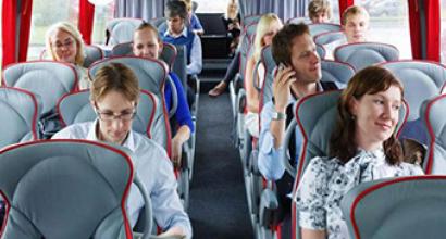
« Small Golden ring Altai» this is the first comprehensive tourist route in Altai, which includes a full range of infrastructure: accommodation, cafes and restaurants, excursion and entertainment services, acquaintance with the beauty and diversity of nature Altai Territory, its historical and cultural heritage, wonderful people. Everyone will be able to choose their own time and specific route: one, three, five or seven days. By car or by bus. The city can be reached by trains "Kalina Krasnaya" and "Vostok", which depart daily from railway station, as well as by buses that leave from the bus station every hour.
The tourist route begins Small gold ring of Altai"in, then - the village, tourist complex "", the village of Altaiskoye, resort, and again Biysk. The total length of the route is about 300 km. The route passes along the famous.
Biysk city – oldest city Altai, founded by personal decree of Peter I. From, defended the southern borders of Russia from Dzungar raids, Biysk turned into a science city Russian Federation. This cozy city with ancient merchant buildings, museums containing many exhibits on nature and. Here is the birthplace of the greatest. Excursion sites: Biysk Local History Museum, Assumption Cathedral, Museum of the History of the Altai Spiritual Mission, Weekend Park tourist complex, place.
Srostki village– the following unique place tourist route in Altai. This is where the famous and beloved writer, actor, film director, Vasily Makarovich Shukshin, was born and raised. Near the village, on Mount Picket V.M. Shukshin installed. Shukshin Days are held annually in Srostki. Excursion objects: All-Russian Memorial, Mount Piket.
« Turquoise Katun» is a special economic zone of tourist and recreational type. This is an actively developing large complex of comfortable and extreme tourism in Altai in the mountains. It is located on the left bank. Here are all the conditions for small trips on foot or on horseback, ATVs, bicycles, along the Katun with rapids, visiting a water grotto, delta and paragliding flights. For more have a relaxing holiday V summer time There is an artificial lake with a whole range of additional services. There are many located here. For lovers of research excursions - at the foot of which is the archaeological “Crossroads of the Worlds”. Excursion objects: monument to the artist and philosopher Nicholas Roerich, Warm Lake.

Lake Aya– another point on the route. Lake Aya is considered " Pearl of Siberia"due to its extraordinary beauty. The most beautiful landscapes, unique natural objects, actively improving tourist infrastructure around the lake attracts a large number of vacationers. Excursion objects: freshwater Lake Aya, mountain
Altai village- center Altai region, located 45 kilometers from Lake Aya. Here in the summer it welcomes guests with exotic plants and medicinal herbs. In the village Altai is a local history museum, where interesting material is collected about the stay of the famous artist and philosopher N.K. Roerich in Altai. Here you can see deer by visiting the Kaimsky maral farm. Excursion objects: “Blooming Valley” NPO “Biolit”, Maral breeding farm “Kaimskoye”, local history museum.
Belokurikha resort town is a unique resort in the Russian Federation. Belokurikha is famous for its healing radon-containing springs, clean mountain air with a high content of air ions useful to humans. – a cozy fairy-tale town with a special microclimate. Treatment in the resort city goes well with well-organized recreation and participation in excursions. There are excellent conditions for organizing and holding international congresses and symposiums. Excursion objects: health Center « water world", water park of the resort hotel "", with a cable-chair lift.
The tourist route ends in the city Biysk. Journey through " Small Golden Ring of Altai» carry out travel companies Biysk, Barnaul and Belokurikha.
Bridge over the Biya River in Altai.
On the surface of the water.
An ancient museum building in the city of Biysk.
Domes on the cathedral. City of Biysk.
Swan winter hut in Altai. Sanctuary "Swan".
The village of Srostki is the birthplace of Vasily Shukshin.
V.M. Shukshin looks at his native village from Mount Piket. Monument to Shukshin.
Great trip to Turquoise Katun in Altai.
Water park on the Turyuzovaya Katun reservoir.
The Great Golden Ring of Altai is more than 2 thousand kilometers of road along the most the most beautiful places 9 cities and 47 districts of the Altai Territory. The opening of the new tourist route “Great Golden Ring of Altai,” according to the authorities, was due to the need to present those areas of the Altai Territory that are mostly hidden from tourists, in contrast to the same popular mountainous part of the region.
Zmeinogorsk was founded in 1736 as a village, after deposits of rich silver-lead ores were discovered. The Zmeinogorsk fortress was part of the fortifications of the Kolyvano-Kuznetsk defensive line. The city developed as a center of mining production and remained the main supplier of gold and silver to Russia for more than a century.
The Gilev Reservoir is a reservoir in the Altai region of Russia, formed by an earth-fill dam in the 70s of the 20th century in the upper reaches of the Alei River. The reservoir came into operation in 1979 and is the largest artificial reservoir in the Altai Territory. The purpose of creating the reservoir was the need to regulate the seasonal water flow of the Alei River, provide a sustainable source of water supply to the Rubtsovsky industrial hub, villages and towns gravitating towards the Alei, as well as to irrigate the lands of the Alei irrigation system, 90 km long, to irrigate the southwestern steppe regions of the region.

Tigiretsky ridge is a mountain range in the north-west of Altai; height up to 2299 m. The ridge is composed mainly of granites and effusive rocks. Up to a height of m it is covered with steppe vegetation, up to 1800 m with taiga forests of fir, larch, and cedar; above that there are alpine meadows and alpine tundra.


The cave received its name at the end of the 18th century, when for many years it became a refuge for the Old Believer hermit Dionysius (in common parlance Denis). For the Old Believers of nearby villages, he was a spiritual shepherd, and the Kerzhaks constantly visited him in his cave cell for blessings and advice.
The town of Pleshyvaya is the highest point of the Anui ridge, which serves as the watershed of the Anui River and the Peschanaya River; has an unusual table-shaped shape. Mountain height m.

Route "Village Aya, Lake Aya "Turquoise Katun".

There is an Altai legend that the Moon (Ay) descended into the valley and captured the cannibal Delbegen there to save the human race. At the place where the moon descended from the sky, a dent formed and Lake Aya appeared. There are other legends that local residents They are happy to tell their guests.


The territory allocated for the placement of the special economic zone "Turquoise Katun" is the largest among all SEZs tourist and recreational type of Russia and is 3326 hectares. The defining characteristics of this site are the stormy Katun River and the combination of various types of pristine natural landscape - mountains up to 1000 meters high, flat areas, pastures and mixed forests. Tourists can visit: a warm artificial lake; the famous Tavdinsky caves; archaeological park “Crossroads of the Worlds” with authentic burial mounds of the Turkic era; monument to Nicholas Konstantinovich Roerich - the famous traveler, artist and philosopher.
S. Liberty Valley - s. Krasnogorskoe-s. Bystryanka Freedom Valley village of Ust-Ishinsky village council of Krasnogorsk municipal district Altai region. Today there are no cultural or social facilities left in the village. Except for the shop and the small sawmill located behind it. Doctors from Ust-Isha come to the village several times a week. Some residents work in Gorno-Altaisk, their children study there and visit the hospital. Young people do not stay in the village. There are currently no tourist facilities organized in the village. Among the interesting facts related to the history of the village, it can be noted that the scenes in the club and library from the film “There Lives Such a Guy” by Vasily Makarovich Shukshin were filmed in the old Freedom Valley club.
The village of Krasnogorskoye was founded in 1811. In honor of Agey Antonov, the creator of the first hydroelectric power station in Siberia, an 8-meter stele was installed in the center of the village. There are year-round tourist bases and rural tourism estates in the area. Of interest to tourists are: the Isha River; Karaguzhinsky Creamery and Cheese Plant with its showroom and the opportunity to taste the plant’s products; mountain landscapes between the Katun and Biya rivers.
S.Bystryanka Today there are no tourist sites organized in the village, although near the village there are burial grounds and burial mounds, which are attributed to the special Bystryanka culture of the 2nd half. VI-II centuries BC e., included in the circle of cultures of the Scythian-Siberian appearance, widespread in the Eurasian steppes from the Danube to Eastern Mongolia. In addition, the Bystryansky creamery, which has won awards at Russian and international exhibitions and produces “Gorny”, “Sovetsky”, “Slavyanka”, and “Swiss” cheeses, is well known.
This is a city of unique architectural appearance, a city of monuments, an original page of Altai. Biysk has architectural, historical and cultural monuments, about 50 archaeological monuments, 11 natural monuments.

At the end of 2012, by decision of the governor of the Altai Territory, the route of the Great Golden Ring was significantly expanded to the west. Kamen-on-Obi, Yarovoye, Slavgorod and Rubtsovsk have been added to the route. Lovers of flat landscapes can improve their health in any corner of the Slavgorod, Kamensky and western parts of the Rubtsovsky district, in rural areas and on the shores of salty and alkaline lakes of the Novichikhinsky, Egoryevsky, Romanovsky and Zavyalovsky districts.
Introduction
The main purpose of transport is the transportation of goods and passengers, and automobile transport ceased to be a luxury and became an integral part of our lives.
One of the most effective reserves for increasing the vehicle fleet is car repair, so much attention is paid to its development and improvement in our country.
The clients of the designed service station will be owners of passenger cars that have become faulty or have lost their functionality while on the road, as well as local residents who have motor vehicles.
The production base of the service station will consist of six posts. This will allow you to perform diagnostic work, tire fitting and washing work, etc.
Problems, purpose and objectives of the diploma project.
Problems:
¾ on the Biysk highway section ¾ Soloneshnoye, there is not a single road service station capable of providing high-quality repairs;
¾ low degree of development of the demand market 11%;
¾ insufficient range of services in the area.
Therefore, the goal of the diploma project is to design a road service station for passenger cars on the Biysk highway ¾ Soloneshnoye, which could satisfy the need for vehicle maintenance and repair and make a profit.
To achieve these goals, it is necessary to solve the following tasks:
¾ perform an analysis marketing research;
¾ perform technological calculation of the service station;
¾ make a selection of technological equipment, technological and organizational equipment;
¾ develop a technological process for restoring alloy wheels;
¾ develop measures for the safe conduct of work, calculate the lighting and grounding of the service station;
¾ perform calculations of the economic efficiency of design solutions.
Justification of the diploma topic
Tourist routes Altai Territory
One of the areas of activity of the Administration of the Altai Territory within the framework of the implementation of a long-term target program is the development of tourist routes that contribute to the popularization of existing and newly built tourist sites, the redistribution of tourist flows throughout the Altai Territory and the consolidation of the efforts of the regional authorities and the business community to expand the list of services provided to tourists and improving their quality.
One of the projects within the framework of this event was the creation of a brand tourist route"Small Golden Ring of Altai".
Figure 1.1 ¾ Scheme of the route “Small Golden Ring of Altai”
In just a few days, vacationers will be able to get acquainted with the beauty and diversity of the nature of the Altai region, its historical and cultural heritage, and wonderful people. The route passes through two cities and four districts of the region. These are the cities of Biysk, Belokurikha, and the districts of Biysk, Krasnogorsk, Altai and Smolensk. Its total length is 280 km, and, depending on the content of the excursion program, its passage takes from two to five days.
Taking into account the positive experience of implementing this project. The Governor of the Altai Territory set a more ambitious task - to develop a new tourist route that would show not only the beauty Altai mountains, but also amazing landscapes and objects of one of the largest plains globe¾ West Siberian.
The interregional cross-border tourist route “Big Golden Ring of Altai” became such a project.
The route passes through the southeastern part of the West Siberian Plain, as well as through the valleys and passes of the northern Altai ranges and includes visits to four cities and 22 districts of the region.
The length of the route is ¾ about 1500 km.

¾ route “Big Golden Ring of Altai”; ¾ radial routes
Figure 1.2 ¾ Scheme of the route “Big Golden Ring of Altai”
The territory through which the route passes has interesting story. In the middle of the 18th century, in order to protect against attacks by the militant Dzungars, the Kolyvano-Kuznetsk defensive line was created here between neighboring defensive structures; its distance did not exceed forty miles. The Russian Cossacks performed military service here. Until now, from Ust-Kamenogorsk in Kazakhstan to Novokuznetsk in Kemerovo region and mainly in the southern part of the Altai Territory, the descendants of the Cossacks live and preserve traditions.
A trip along the “Great Golden Ring of Altai” allows you to visit not only these historical places, but also to travel to the Cossack settlements of Kuzbass and Kazakhstan. Taking into account also the fact that the route passes through part of the Chuysky tract, located on the territory of the Altai Republic, and the territory of the Talmensky district borders the Novosibirsk region, we can rightfully assign the status of an interregional cross-border tourist route to the “Great Golden Ring of Altai”.
The creation of an interregional cross-border tourist route in the Altai Territory is not only an important area of tourism development, but also a large-scale project for the socio-economic development of municipalities in the Altai Territory.
All these events contribute to the creation of an attractive image of the region as the largest tourist territory in Russia, as well as the development of automobile service in the Altai Territory.
1.2 Natural and climatic indicators
The Smolensk district of the Altai Territory is located in the southeastern part of the region. There are 31 settlements on the territory of the district, the largest villages are: Anuiskoye, Solonovka, Sychevka, Tochilnoye, Novotyryshkino; villages: Linevsky and Verkh-Obsky. There are 11 intra-district municipalities on the territory of the district.
The relief in the northern part is rugged and flat; in the south - hilly, foothills.
The climate is continental. Average January temperature -16 °C, July 20.2°C. Annual precipitation - 630 mm.
The following rivers flow through the region: Ob, Katun, Anuy, Peschanaya, Kamenka, Poperechka; there are more than 20 lakes and ponds, the most large lakes: Komlevo, Rogulichnoe, Zakharovo, Pavlovo.
Grow: pine, birch, poplar, elm, maple, spruce, larch, sea buckthorn.
Lives: roe deer, bear, elk, fox, hare, wild boar, badger, polecat.
Socio-economic development of the region
The main direction of the economy is Agriculture. The main industry is crop production with developed livestock farming. In the area there is Linevsky Breeding Plant LLC, a poultry farm of the KSUP Smolenskaya Poultry Farm, and antler reindeer breeding is developing.
In the area there are 18 general education and 12 preschool institutions, houses of culture, clubs and libraries.
The following highways pass through the region: Biysk - Belokurikha, Biysk - Aleysk, Biysk - Petropavlovka, Biysk - Soloneshnoye.
© Kirill Kukhmar/TASS
The world of shamans and mountain spirits, the hidden paradise country of Shambhala or Belovodye is one of the most beautiful territories of Russia, which still remains a mystery
The word “Altai,” which translates as “golden land,” evokes a variety of associations, usually associated with secrets, spirits, and the extraordinary beauty of these places.
The Altai Republic is becoming more and more popular with tourists every year - up to 2 million guests come here every year, and many return here again. Here are routes for every taste: from multi-day hikes to comfortable trips by car. On which routes you can test your strength and, in general, how Gorny Altai is ready to surprise tourists - read the TASS material.
Climbing Belukha
For indigenous Altai people, Mount Belukha is a sacred symbol, for professional climbers it is a test of strength. The most high point Mountain Altai (4509 m) is located in the Ust-Koksinsky region. It is from the Belukha glaciers that the Katun River originates. The classic ascent to Belukha for people with climbing experience and physical fitness is a 12-day route with a 3A classification.

Lakes near the village of Aktash in the Ulagansky district
© Kirill Kukhmar/TASS
From Barnaul, Biysk or Gorno-Altaisk a transfer is organized to the village of Tyungur, from where the route begins with a walk, during which a panoramic view of Belukha opens to the Ak-Kem mountain shelter. Then preparatory classes on the glacier begin: training in the technique of moving on ice, working in teams, acclimatization trek under the Delaunay Pass in good weather. Afterwards - a climb to the pass itself, about 300 m long, along a snow-ice slope with a steepness of 35-45 degrees, an overnight stay on the glacier in tents and what tourists come here for - climbing to the top of Belukha.
The views of Altai that open from here are truly fabulous: these are the same Roerich colors - the bright blue of shadows on the glaciers of neighboring mountains, sparkling snow, pink and purple mountains at sunset and sunrise - the beauty that artists and photographers love, and that same soul Altai, which he cannot open to everyone.

Katun River in Ongudai district
© Kirill Kukhmar/TASS
See Belukha and...
Those who do not have mountaineering training, but are physically strong, are offered to see Belukha from the outside - this is a 12-day hike to the foot of the sacred symbol, but without climbing and without a sports category of difficulty. Here tourists are offered hiking romance - overnight stays in tents on the banks of the Ak-Kem River, at the sources of the Tukhman River, Lake Kulduayry, the Tekelyu River, climbing to the swampy Sarybel plateau, crossing the Ak-Kem mountain stream, a short excursion to the Yarlu gorge.
Many tourists, as the organizers of such tours note, appreciate this area for its extraordinary energy: yoga tours are organized here, representatives of various schools of philosophy hold their seminars. Actually, tourists go to Altai for this energy of the mountains.
The same route includes a descent into the Kucherlinskoe gorge with the lake of the same name, a visit to the grotto in the valley of the Kucherla River and a parking lot ancient man, where petroglyphs - ancient ritual writings - have been preserved.
To the top of the world through Multinskie Lakes
There are many roads leading to Belukha, and one of them runs through the Multinskie Lakes. The route “To the Top of the World: Koksa - Katun - Multa - Belukha” is a combined route, including walking, horseback riding, car trips and kayaking. That is, a little bit of everything you can get from local extreme sports. At the same time, it gives a lot of impressions, but is not demanding in terms of physical training; children from 14 years of age are also allowed here.

Bank of the Multa River in the Ust-Koksinsky district
© Dmitry Feoktistov/TASS
The route goes through the picturesque Ust-Koksinsky region, surrounded by the peaks of the Katunsky ridge. The group will have to travel part of the route on light two-seater boats - kayaks, which will be taught by an instructor. The route, designed for eight days, includes an ascent to one of the most famous lakes in the Altai Mountains - Nizhny Multinsky. It is located at an altitude of 1627 m above sea level and is the largest in the system of five Multinsky lakes.
The route has a beautiful finale - a horseback excursion to the observation deck of Mount Baida, about 2 thousand meters high, from where you can see the Altai peak of the world - Mount Belukha.
Along the protected Altai
Mountain Altai is a protected area of Russia; there are many natural monuments of not only Russian but also world significance, nature reserves with unique flora and fauna. The 15-day route reveals the sights of all seven specially protected natural areas of the Altai Republic and allows you to visit various parts of the region in a short period.
The route starts from Lake Manzherok - a natural monument located at an altitude of 373 m above sea level. The lake is one of the few in Altai that has time to warm up, so you can swim here. The route also includes a visit to the Tavdinsky caves on the border of the Altai Territory and the Altai Republic, the entrances to them are located at steep cliffs, along which the stairs are carried. Here in ancient times hunters performed their rituals, and later - Old Believers.

Chemal hydroelectric power station, where the museum now operates
© Kirill Kukhmar/TASS
Also on the route are two objects in the Chemal region: the Chemal hydroelectric power station, built in 1935 by prisoners, now a museum, and Patmos, a rocky island in the middle of the Katun River. The Orthodox Church of the Apostle John the Theologian was built on it, and on one of the rocks of the island an image of the Virgin Mary and Child was carved. The same route includes a visit to the Kamyshlinsky waterfall, the Katunsky biosphere reserve, an excursion to the house-museum of Nicholas Roerich, where he stayed when traveling through Altai, the museum of rock paintings "Tyalbak-Tash tract", the mysterious Lake of Geysers of turquoise color, which does not freeze even in temperature below zero.

Geyser lake near the village of Aktash in the Ulagansky district
© Kirill Kukhmar/TASS
You can go down from the Ulagan plateau to the Chulyshman valley along the steep Katu-Yaryk pass and visit south coast Lake Teletskoye. This route is varied in terms of travel methods - by car, on foot, on rafts, on a boat, so it is convenient for unprepared tourists.
Hiking to Aktru Gorge
The area of Mount Aktru (or Akturu) is one of the main centers of mountaineering in the Altai Mountains with routes of varying difficulty. One of the most popular is hiking to the Aktru Gorge, where the mountaineering camp of the same name operates. For such a hike you do not need special training or complex equipment.
The route includes an 8-kilometer climb along the Aktru River, an excursion to the waterfall, observation deck Maly Aktru, radial exit to Blue Lake, climbing up a steep path to the Uchitel pass with views of the beautiful Kurai Basin, an excursion to the Martian Valley, where, due to the emergence of multi-colored clay on the surface of the hills - red, yellow, brown, white - the landscape looks more like the scenery for a science fiction film than to the earth's mountains.
The route also includes a visit to the Tarkhata megalithic complex - this archaeological site, an ancient observatory of the late Bronze Age - early Iron Age. It represents a circle with a diameter of 60 m, lined with stone blocks with rock paintings.

Fields near the Kuzbass - Altai highway in the Pervomaisky district
© Kirill Kukhmar/TASS
Along mountain rivers
Altai is a favorite place for water tourists: mountain rivers make it possible to choose routes of any complexity category. Representatives of the tourism industry categorically do not recommend that non-professionals go on routes of the fifth and sixth categories without preparation with such difficult sections as the Karagem breakthrough on the Argut River, travel along the Bashkaus River, the upper and middle Chulyshman.

Biya River in Ongudaysky District
© Kirill Kukhmar/TASS
And here are the routes for extreme sports lovers: rafting on the Chuya River for eight days and 12-day rafting on the Chuya and Katun. Chuya is the largest tributary of the Katun with a length of more than 300 km. On this rafting route, the tourist will have to overcome the rapids of the Mazhoysky cascade - these are V-VI categories of difficulty, and feel the boiling power of the river on the rapids with the telling names Burevestnik, Behemoth, Turbine, Horizon.
Here, on the mountain river, every year the international rafting and water tourism competitions “Chuya Rally” are held. At the same time, for those who are not in the mood for extreme sports, the Altai Mountains offer many short excursion rafting trips - from several hours to one day. These are rafting trips from camp sites along the banks of the Katun River without difficult rapids, for example from the villages of Ust-Muna and Ust-Sema.
In a swimsuit in the snow
There are many horse routes to the Karakol lakes in Altai, so a tourist can leisurely see the beauty of the Altai Mountains in a few days. Actually, it is impossible to get there except on horseback or on foot - the road ends 30 km before the destination. Karakol is a picturesque group of seven lakes on the western slope of the Iolgo ridge. The lowest lake is at an altitude of 1820 m above sea level, the highest is at an altitude of about 2097 m.

Horses on highway in Choysky district
© Kirill Kukhmar/TASS
This place is unique in that, due to elevation changes, you can simultaneously visit several climatic zones. The cedar taiga is adjacent to alpine meadows, and the upper lakes are adjacent to alpine tundra.
The route “To the Karakol Lakes” takes 10 days, and leaves impressions for a lifetime - this includes a mountain tan (experts advise taking sunscreen with you), and the opportunity to take pictures in a swimsuit in the snow, and, of course, a reason to make friends with horses. On this route, tourists will see snowfields in the July heat, a red carpet of mountain flowers - lights, shy tundra partridges and dwarf birches, visit the Karakokshinskaya cave, and pass the Saturday pass, from which views of the Bai-Ayuk lakes open up.
And here you can visit the “Castle of Mountain Spirits”, famous both among the indigenous peoples of Altai and among tourists - a bizarre pile of rocks that from a distance really resembles a castle. According to local beliefs, this is a haven for the spirits of Altai, and if you listen closely, you can hear their whispers - a kind of sound of the wind in the stones.
To the ends of the earth for grayling
The horse route “Journey to the End of the Earth”, far from well-worn tracks, runs along the spurs of the Korgon Range in the Ust-Kansky (Altai Republic) and Charyshsky (Altai Territory) regions. This is the land of shepherds and hunters, guests from " big land"appear here infrequently. The route, despite the distance from civilization, is simple and suitable for beginners.

Village in Ongudaysky district
© Kirill Kukhmar/TASS
The Korgon ridge is a complex system of ridges and spurs with heights of 2–2.2 thousand m. The relief is dynamic - passes, gorges, peaks approaching each other. Here, far from your home, you truly feel like a pioneer, and the mountain fog hides bright colors, turning them into pastel halftones, creating even more beautiful colors. O greater isolation from the world.
The route lasts six days, during which you can come up with names for the lakes yourself - there are many of them along the way, but not all of them have names. During the trip, you can visit a lake that supposedly was once a volcano - that’s why its shores are strewn with red and purple stones, which is why the water in it appears black.
After ascending to the upper reaches of the Bolshoy Kaisyn River, a stop is made at Fish Lake. The name speaks for itself: there is a lot of fish here, in particular grayling, so avid fishermen and just amateurs will have something to do. Also on the route is a horse trek to the Valley of the Seven Lakes - a place somewhat similar to the Karakol system, but almost without tourists.

Lake near the village of Aktash in Ulagansky district
© Kirill Kukhmar/TASS
Winter in Altai on snowmobiles
Snowmobile routes have also begun to be offered in Altai, and now the region has something to offer tourists even in winter.
Route "Taiga Dead End" - IV category of complexity. Guests are invited to get acquainted with the North-Eastern Altai - this is an endless sea of mountain ranges covered with coniferous forests. On a vast expanse of mountain taiga terrain of 80 thousand square meters. no km settlements, electricity, roads, only occasionally you come across hunting huts where tourists will spend the night.

Lake Manzherok in the Mayminsky district
© Kirill Kukhmar/TASS
The route is designed for 10 days - to begin with, tourists are introduced to motor vehicles at the Manzherok tourist complex and make a test ride on snowmobiles. The route route goes through difficult terrain - along the spurs of the Sumultinsky ridge and the Iolgo ridge at an altitude of 1–1.8 thousand m, and the total length of the route is 600 km. During the snowmobile trip, guests visit a unique natural object- Beduya hot springs, where a stream with a water temperature of 32 degrees makes its way through the snow, in which, of course, you can swim - try an exotic Altai spa.
The nearest housing in these places is 60 km away: this is the village where the famous hermit Agafya Lykova lives. The snowmobile route along this route passes through the Karakol Lakes, the Pyzha River tract, the Karakokshinskaya Cave, Teletskoye Lake and other beautiful and unusual places in Altai. The route ends at the only casino in Siberia, Altai Palace - with comfort and entertainment of a non-natural nature.
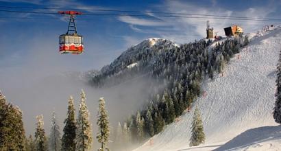
Route for skiers
The Altai ski route gives winter sports fans the opportunity to try out virtually all the specialized sites in the region. This is a visit to four ski resorts in different points Altai.
The list of places for skiing includes the Manzherok ski complex near the village of the same name with five slopes up to 285 m long, rope tows and chair lifts, the Seminsky Pass training center at an altitude of 1.8 thousand m with three slopes up to 200 m long for experienced and beginners, ski complex "Biryuzovaya Katun" - three well-prepared ski slopes of varying complexity and a total length of 3.5 km.

Climbing the mountain Malaya Sinyukha in the territory ski resort"Manzherok"
© Kirill Kukhmar/TASS
In the finale - the Artybash complex near Lake Teletskoye - this is a descent along two tracks with a total length of 2.3 km with a height difference of 250 m, there is a springboard for snowboarders, and for extreme sports enthusiasts - an ascent on a snowmobile and snowcat to the top of the mountain and a descent along powder 3.5 thousand m with a drop of 840 m. The route program also includes an excursion to the maralnik (semi-evergreen ornamental shrub of pink-purple color with a pronounced aroma).
For young athletes and those who plan to start skiing for the first time, there is a training ground for learning skiing skills on the slope of Mount Sinyukha, with a rope tow and a descent only 100 m long. Tourists with their uniform are transported from base to base by bus, and, if desired, equipment can be rented at the same complexes. The entire route takes eight days.