The largest and longest glacier on earth. Ross Ice Shelf
There is so much we don't know yet.
The Ross Ice Shelf in Antarctica is, on this moment, the largest floating block of ice in the world: the size of the glacier is, no more, no less, the size of Spain, and its thickness is almost a kilometer. The ocean beneath it is regarded by experts as one of the most important but least understood parts of the climate system.
A team from New Zealand's Ross Ice Shelf program melted a hole hundreds of meters down to explore the ocean and reveal the glacier's vulnerability to climate change. Their measurements showed that the ocean was warming and renewing itself, but not in the ways everyone expected.
Hidden Ocean.
Over the past centuries, all the largest blocks of ice have been discovered near the coast of Antarctica. These behemoths are holding back the Antarctic Ice Sheet, which, if released into the ocean and further melted, could raise sea levels so much that it would forever change the landscape of our planet.
An ice shelf looks like a giant sheet of ice that forms when regular glaciers break off from land and merge together as they float close to the shore.
Ice shelves lose ice either by large chunks breaking off or by melting ice from below. Because the water flowing beneath the Ross Ice Shelf is cold (minus 1.9 degrees Celsius), it is called a “cold cavity.”
If the water warms, the future of the ice shelf and ice upstream could change overnight. However, for now, the ocean located under the glacier is excluded from all current models of the future earth's climate.
In the late 1970s, an international team of scientists attempted to explore this ocean. Over the course of five years, the team repeatedly tried to drill through the ice using several types of drills, but in vain. Now, with new and improved technology, the New Zealand team completed the job in one season.
The main conclusion is that seawater circulates through the cavity, flowing into the seabed as relatively warm, salty water. She eventually finds her way to shore - except, of course, coastline under the ice (800 meters down).
There it begins to melt the ice shelf from below and then flows through the glacier floor back to the open ocean.
Peering through the hole into the ice.
The New Zealand team, including drillers, glaciologists, biologists, seismologists, oceanographers, worked from November to January, supported by tracked Vehicle and, if local weather permitted, DHC-6 aircraft flew in to help.
As is often the case in polar oceanography, getting to the ocean was the hardest part. The team was faced with the task of melting a well several hundred meters deep and only 25 centimeters in diameter! But as soon as the well reaches a depth of 300 meters, the task becomes dramatically simpler. The risk of biological contamination in such conditions is reduced by many percent than if the research was carried out, for example, in the jungle. Nevertheless, the threat of freezing of all instruments or the well itself has not been canceled.
Moving World
The team settled down right in the middle of the glacier. But if their camp stood motionless, then the same could not be said about everything around.
The ocean circulates slowly, perhaps renewing itself every few years. The ice is moving too, about 1.6 meters every day. The sheet of ice floats under its own weight, pulled inexorably toward the edge of the ice shelf, where it breaks apart like massive icebergs on rare occasions. The slab also sinks and rises with the daily tides.
In addition to melting, the ice shelf can also increase in size. Drifts may form at the top, and water may freeze at the bottom.
Thus, not a single thing in this cold world stands still. Interesting fact: The research camp is located 160 kilometers from the place where Robert Falcon Scott and two members of his team were buried centuries ago during their return from the South Pole. Therefore, it is safe to say that their bodies also move from place to place.
What does the future hold for us?
If the ocean beneath the ice is warming, what does that mean for the Ross Ice Shelf, the ice sheet it holds back, and future sea levels?
The team collected detailed data on temperature and salinity to understand how the ocean circulates inside the cavity. They will be able to use this data for tests and computer modeling, as well as to assess whether the ice at the bottom of the ice shelf is melting or, conversely, the water is freezing and the lower part is growing.
But now we can say that compared to the late 70s, the temperature in the ocean has become warmer. In addition, the concentration of salt in the ocean has decreased. It was also discovered that the glacier below was covered with crystals. The same crystals can be seen in sea ice, which floats next to ice shelves. But this layer of crystals was not as massive as that on the Amery Ice Shelf.
None of the above is included in modern models climate system. Neither the effect of warm, salty water flowing into the cavity, nor very cold surface waters, nor ice crystals affecting heat transfer to the ice, nor ocean mixing at ice fronts.
It is not entirely clear whether the water beneath the glacier plays an important role in how the world's oceans work, but what is certain is that it influences the ice shelf.
To summarize, it must be said that ensuring the integrity of ice shelves is our primary task.
“Planets of the Solar System” - Mars. The Great Red Spot, a giant hurricane in the atmosphere of Jupiter. Mir station. Neptune. Mir station is located above the waters Pacific Ocean. Sun. Mercury and Earth. The Martian year lasts 687 Earth days. Pluto. The third major planet from the Sun in the Solar System. Pluto is the smallest of the major planets in the solar system.
“Minor planets” - The Moon’s own thermal radiation is insignificant. Venus. Atmosphere and water on Mars. Mercury has a magnetic field. The distance of Mercury from the Earth is from 82 to 217 million km. Dimensions, shape and mass of Mercury. Atmosphere and physical fields on Mercury. The highest peak of Venus is Mount Maxwell - height 12 km.
“Giant Planets” - Involving class students in the general conversation. Later they saw that Saturn had not one ring, not three, but more. The brightest ring, B, is medium, and ring C is very faint. Satellites of Jupiter. Uranus. The flattened ball is “put on” a bright, very big ring. Pluto has a satellite. Jupiter is the largest of all the planets in the solar system.
“Geography 6th grade Glaciers” - Classification of glaciers. Peroto Moreno Glacier (Argentina). Could glaciers form in our area now? Iceberg Ice Shelf. Mountain cover glaciers. The entire area from which the river collects water? How are interstratal waters formed? Which lake is the largest in area? Monument to those killed as a result of the collapse of the Kolka glacier.
"Formation of Planets" - Calcium. Eagle Nebula. The bulk of the protoplanetary disk leaves the Solar System. "Catastrophic" hypotheses. Magnesium. The emergence of planets. Magnesium silicates, iron and nickel. Let's keep the Earth the way we got it! Formation of planets. The Horsehead Nebula is part of a dark dust cloud.
"Planet of Knowledge textbooks" - " art", 1-4 grades. Educational and training complex for primary school. "Russian language", grades 2-4. Training sheets. Cognitive activity. Textbooks; workbooks; didactic and methodological aids. Creative tasks. Qualitative tasks. Project activity (grade 2). Unity of approaches to organizing educational and extracurricular activities.
Speaking about the largest glaciers in the World, it is worth mentioning that they exist in several types: corvettes, valley glaciers, cover glaciers, etc. The vast majority of glaciation on Earth belongs to ice caps Antarctica and Greenland, that is, to cover glaciers. I would just like to note that the thickness of the ice there reaches enormous levels - more than 4 km.
Large ice caps are found on the islands Canadian Arctic Archipelago. They amount to tens of thousands of square kilometers. Huge ice fields follow them Spitsbergen.
Approximately 50 percent of the total area North Island archipelago New Earth majestic glaciers have been reclaimed. On an area of almost 20,000 km2 there is a continuous ice shell, which has a length of 400 kilometers and a width of 70-75 kilometers. At the same time, the thickness of the ice is more than 300 meters. In some places the ice goes into the fjords or breaks into the sea, forming icebergs.
Vatnajökull(oh, those Scandinavian names!) is the largest glacier on the island of Iceland. It is located in the southwestern part of the island and occupies 8% of its territory, or 8,133 km2.
Jostedalsbreen Glacier is the largest continental glacier in mainland Europe, covering an area of 487 km2. Located in Norway. It has more than 50 branches, including the famous glaciers Briksdalsbreen and Nigardsbreen.
South America
Now let's move from northern Europe to South America. Patagonian Ice Plateau is no less amazing. It consists of two parts: the North, spread over an area of 7,600 km2, and the South, over an area of 12,000 km2. The prevailing surface heights are about 1500 m. Rocky peaks and mountains rise among the ice ( highest point– Bertrand town, 3270 m). At the level of the glacial plateau, 7000–8000 mm of precipitation falls per year. Outfall glaciers flow from the plateau, many on the eastern side ending in fjords, and on the west - in lakes. The largest of them Perito Moreno and Uppsala. The first has an area of 250 km2. The width of the tongue is 5 km, average height- 60 m above the water surface. The speed of its movement is 2 m per day. However, the mass loss is approximately the same, so the glacier tongue has not retreated or advanced for 90 years. The length of the Uppsala glacier is 60 km, width up to 8 km, area 250 km2. Descends into the northern arm of Lake Lago Argentino.
North America
Now it's North America again. We have already spoken about the Canadian Arctic Archipelago. Another place where large glaciers accumulate is Alaska. Bering Glacier- the largest mountain (tree-like) glacier North America. It originates from the ice fields on the Chugach (4116 m) and St. Elias (5489 m) mountains in Alaska (USA). Length (from the most distant source) 203 km, area about 5800 km2. It emerges on the low-lying coast of the Gulf of Alaska, where it forms a foothill ice blade about 80 km long and 43 km wide.
Malaspina- foothill glacier on south coast Alaska, between Yakutat Bay and Ice Bay. Area 2200 km2. Formed by several glacial streams descending from the St. Elias Mountains. The feeding area is the Seward glacial basin, located at an altitude of 1500-2000 m. Since the 30s of the 20th century, the glacier has been shrinking, retreating from the ocean coast, leaving a shaft of the terminal moraine, gradually overgrown with coniferous forest.
Alaska's glaciers are no less impressive Hubbard(length 122 km) and Colombia(length 66 km, area 1370 km2). The latter's extensive firn fields lie at altitudes of about 3600 m, and the main glacier trunk, 4 km wide, reaches the Pacific Ocean at Prince William Sound.
High mountain valley glaciers
Previously, we talked about glaciers at high latitudes that feed at relatively low altitudes. Now let's turn our attention to the glaciers located in the highest mountain systems of the world. These are typical mountain-valley glaciers. Although most of them have a complex tree-like structure and many tributaries, they are distinguished primarily by their long valley tongue.
Oddly enough, the highest Mountain chain has relatively small glaciers on earth. Glaciers of the Himalayas c do not exceed a length of 30 km (Gangotri glacier - 26 km, Zemu glacier - 25, Rongbuk glacier - 19 km).
The largest number of large glaciers is located in the Karakoram mountain system. These include Baltoro, Siachen, Biafo. We will turn to them a little later, but now we will turn our attention to one of the most interesting and largest glaciers in the world - Fedchenko.
Pamir
Fedchenko Glacier, the first largest in the CIS and one of the largest glaciers in the world: its length is 77 km, width - from 1700 to 3100 m. It is located in Tajikistan, in the Pamirs. The glacier originates at the foot of Revolution Peak on the northern slope of the Yazgulem ridge and flows along the eastern slope of the Academy of Sciences ridge. The ice thickness in the middle part of the glacier reaches 1000 m, total area glaciation and snowfields - 992 km2. The upper end of the glacier is at an altitude of 6280 m, and the lower end is at 2900 m, the height of the snow line is 4650 m. The Seldara River flows out of the glacier.

The history of the discovery of the glacier goes back to the end of the 19th century. In 1871, the first Russian expedition, led by A.P., arrived in the Pamirs. Fedchenko (famous naturalist and explorer of Turkestan). The expedition outlined the general outline of the Pamir ridges, exploring the Trans-Alai ridge in more detail and discovering the highest peak of this ridge (now Lenin Peak - 7134 m). At the same time, the expedition also discovered a huge glacier, now bearing the name Fedchenko. In the basin of this glacier there are highest peaks The Pamirs, with their celestial heights and inaccessibility, attract the attention of domestic and foreign climbers. In the upper reaches of the glacier, Revolution Peak (6974 m) is located; the highest mountain peak can be seen almost anywhere on the glacier former USSR and the second in the Pamirs - Communism Peak (7495 m). Near Communism Peak are Russia Peak (6852 m) and Garmo Peak (6595 m). Currently, the highest hydrometeorological observatory in the world (more than 4200 m) is located on the Fedchenko glacier.
Karakoram
As already mentioned, the largest number of large high-mountain glaciers are located in the Karakoram mountain system. These include: Siachen, Baltoro, Biafo. Baltoro is located in the Central Karakoram southeast of the city of Chogori (K2) - the second highest peak in the world (8611). The length of the glacier is 62 km, area 750 km2. According to some data, the glacier's area is 1227 km2 and if these figures are correct, then they are larger than that of the Fedchenko glacier (992 km2). Siachen- valley tree-like glacier in Karakoram (India). Length 76 km, area about 750 km2. It flows from the eastern slope of the Konduz ridge at the junction with the Karakorum watershed ridge at altitudes of up to 7000 m. The glacier flows to the east, over a long distance it is partially (in some places completely) covered with a cover of rock fragments; ends at an altitude of 3550 m. Biafo Glacier located on the southern slope of the Karakorum. Length about 68 km, area 620 km2.
Tien Shan
South Inylchek- the largest glacier in the Tien Shan and the second largest mountain glacier in the CIS countries after the Fedchenko glacier in the Pamirs. It is located between the Tengritag and Kokshaaltau ridges. Its length is 58.9 km, area 567.2 km2. The glacier originates in the Khan Tengri region, and its tongue drops to 2800 m. Southern Inylchek flows several kilometers to the north, and then turns sharply to the west. The thickness of the ice in the lower parts of the tongue is 150-200 m. The powerful left tributaries of the glacier, located in the northern spurs of the Kokshaaltau ridge, have their own names: Zvezdochka, Dikiy, Proletarsky tourist, Komsomolets (from east to west). If you look at the glacier from above, it looks like a blue-white tree with longitudinal dark stripes of median moraines on its main trunk and a series of light branches of varying lengths and thicknesses. The largest of the tributary glaciers are the Zvezdochka and Dikiy glaciers.
Alps
Great Aletsch Glacier, located on the southern slope of the Bernese Alps in Switzerland, is the largest glacier in the Alps, covering an area of 87 km2, and taking into account the area of the four firn basins that feed it, about 117 km2. The total length of the Aletsch glacier is about 24 kilometers. Thickness up to 900 m.
Caucasus
Bezengi- a complex valley glacier, the largest in the Caucasus. Located on the northern slope of the Main Range at the foot of the Bezengi Wall. It descends from the peaks of Shkhara and Dzhangitau to a height of 2080 m and serves as the main source of the Cherek-Bezengisky River. Length 17.6 km, sq. 36.2 km2. Firn line at an altitude of 3600 m. The lower 5 km of the glacial tongue are covered with melted debris. From 1888 to 1966, the tongue retreated by 1115 m, and currently continues to retreat. More than 10 of its former tributaries have turned into independent glaciers. Bezengi is followed by the Dykh-Su glaciers (length 13.3 km, area 34.0 km2) and Karaug (length 13.3 km, area 26.6 km2).
Altai
The entire Altai glaciation taken together is nothing more than one of the largest valley glaciers in the world. Although the same can be said about the Caucasus. But even so, the largest glaciers in Altai are impressive. Potanin Glacier(Potanin-Musen-Gol) has an area of 38.5 km2 and a length of 11.5 km. Its vast snow field is surrounded by five peaks arranged in a horseshoe shape. On the right, the Potanin glacier receives 2 glacial tributaries - the upper smaller and lower larger Alexandra glacier (A.V. Potanina). On the left side of the glacier there is a single small tributary. The tongue of the Potanin glacier has a slight slope; There are cracks only in the middle reaches. It descends to an altitude of 2900 m, the lower part is covered with moraine. Melt water flows into the Tsagan-Gol river basin. Glacier V.V. discovered Sapozhnikov in 1905 and named by him in honor of G.N. Potanin.
Taldurinsky glacier (Big Taldurinsky) lies on the elephants of the South Chuya ridge. Length 7.5 km, area 28.2 km2. The height of the end of the glacier is 2450 m. The thickness of the ice reaches 175 m. It is the largest glacier in the Russian Altai. It originates in the circus, framed by peaks about 4000 m high (Iiktu and others). It has a narrow exit to the northeast, into the valley of the Taltura River.
Sapozhnikov Glacier (Mensu)- the largest in the Katunsky ridge of Altai (descends from the slopes of Belukha) its length is 10.5 km, area - 13.2 km2.
The most unique, famous glaciers.
The glacier is approximately 62 km long, making it the longest glacier in the world outside the polar regions. The glacier is located in the Gilgit-Baltistan region of Pakistan. Baltoro is surrounded by the Karakoram Mountains and is located between the Baltoro Muztagh ridge from the north and the Masherbrum ridge from the south, the most high mountain in this area K2 (8611 m). The lower part of the glacier is located at an altitude of 3400 m above sea level, followed by the melting zone of the glacier, which gives rise to the Biafo River.
Concentrated in Antarctica greatest number ice, and, consequently, reserves fresh water on the planet. The maximum thickness of ice on the continent is 4800 meters, the average thickness of ice covering the continent is 2600 meters. Moreover, in the central part of Antarctica the ice thickness is greater, and towards the coast it is less. The ice seems to flow from the continent into the ocean. When the ice reaches the ocean, it breaks off into large pieces called icebergs.
The volume of glaciers is 30,000,000 square kilometers, which is 90% of all ice on the planet.
The Kilimanjaro Glacier is not one of the largest glaciers, but its uniqueness is that it is located near the equator in Africa. The Mount Kilimanjaro glacier was formed 11,700 years ago. Since 1912, observations have been made that the area of the glacier began to gradually decrease.
By 1987, the glacier's area had decreased by more than 85% compared to 1912.
Now the absolute area of the glacier is less than 2 square meters. km. According to scientists, the glacier will completely disappear by 2033.
Aletsch Glacier
The Aletsch Glacier is the largest glacier in the Alps. Its length is 23 km, the area of the glacier is 123 square kilometers. The glacier includes 3 adjacent small glaciers. Maximum depth ice is 1000 meters. The glacier has been included in the list since 2001 World Heritage UNESCO (object no. 1037bis).
 |
 |
 |
Harker Glacier is located on South Georgia Island in the southern part Atlantic Ocean. The uniqueness of the Harker Glacier is its method of formation. This glacier is a tidal glacier. Discovered in 1901 by a Swedish expedition led by Otto Nordenskiöld and Karl Anton Larsen. The glacier is quite stable in its area and volume, although its outline changes over time.
Jostedalsbreen Glacier
The Jostedalsbreen Glacier is the largest glacier in continental Europe. The length of the glacier is 60 km, the area is about 487 square kilometers. Like most other glaciers in the world, Jostedalsbreen is gradually decreasing in size and volume. In 2006, one of the glacier's branches shrank by 50 meters in a few months.
Vatnajökull Glacier
The Vatnajökull glacier is located in Iceland, it is the largest glacier in Europe, so its area is 8100 square kilometers, the volume of the glacier is estimated at 3100 cubic kilometers. The glacier covers volcanoes, and inside the glacier there are caves formed by geysers - hot springs of water. The maximum ice thickness is about 1000 meters.
Hubbard Glacier is located on the border of Alaska and Canada. The glacier was discovered in 1895. The length of the glacier is 122 kilometers. The glacier ends up in Yakutat Bay. The height of the ice in the bay reaches 120 meters above sea level, the width of the glacier near the bay is from 8 to 15 kilometers, depending on the time of year.
The Franz Josef Glacier is located in New Zealand. The glacier is 12 kilometers long and was discovered in 1859. The glacier has phases of increase and decrease; after 2010, it entered an active phase of decrease (retreat).
 |
 |
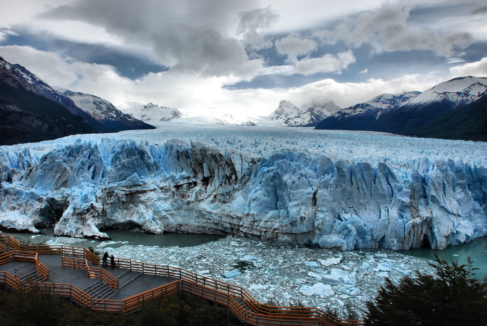 |
The Perito Moreno Glacier is located in the southwestern part of the province of Santa Cruz, Argentina.
The length of the glacier is about 30 km, the area of the glacier is 250 km. square. The glacier moves along the mountain slopes to Lake Argentino at a speed of about 2 meters per day. Periodically, a glacier covers the lake, dividing it into 2 parts. The water in the southern part of the lake, due to rivers and streams, begins to rise compared to the northern part. The difference in levels is more than 30 meters, under the influence of water pressure, the isthmus collapses, and streams of water rush into the northern part of the lake.