Triangular Lake how to get there. Triangular Lake - a unique corner of Russia
To the website
Guidebook of Triangular Lake with photographs. Karelia
Overall plan
How to get there
1) To Vyborg by any route. If you want to visit Vyborg, then
2a) It is necessary to turn towards Kamenogorsk / Svetogorsk / Lesogorskoe. To do this, already in Vyborg, go along the main road to the station and, before reaching the station ~500 meters, at a church on a steep slope with a large inscription “Christ is Risen” (luminous letters about two meters high), turn at the intersection of three roads with a traffic light not to the station (left ), and to the bridge over the railway d(right). Further along the bridge over the railway d, along the bridge across the bay, along the main road, to the border guards.
If you don’t want to go to Vyborg, go through the interchange (not to Vyborg, but to Helsinki), then turn at the junction where there is turns to Vyborg and Kamenogorsk / Svetogorsk / Lesogorskoe. After 1.5 km there will be a border post.
3) From the border guards on the road to Kamenogorsk / Svetogorsk / Lesogorsk (main) 9.4 to the sign “Kamenogorsk - straight, Lesogorsk, Svetogorsk - left”. You need, of course, to the left. The fork is very large, triangular, with high-quality road markings.
4.1) After 37.6 km there will be a railway d relocation After another 3.7 km you will see concrete bus stops (on both sides of the road). This is the turn to the village .L axial and the village of Topolki (from the border guards to the turn 41.3 km, from the crossing - 3.7): Turn right, before reaching the right bus stop. The road you turned onto before joining the main one branches so that the bus stop is on an island. After 100 meters there will be a billboard with the picturesque inscription “Losevo”. Follow this road for 2.3 km to a village of 6-8 five-story buildings.
5) Already in the village there will be a fork: a good asphalt road goes to the right, straight up the hill past the five-story buildings (they will be on the left) there is a road along which you need to go. Along the road you go to the outskirts of the village, to the beginning of the dirt road (2.4 km from the stops). Before the start of the dirt road, on the right, about 50 meters from the road, there will be the OKiAN club (a one-story house with a porch). The primer initially goes downhill. Local residents know this car path as the road to the village of Topolki.
6) Drive along the main road everywhere. After 3.1 km there will be a crossroads, an equivalent road adjoins your road on the left, a field on the right and behind the field a forest and a lake. In the middle of the intersection there is an island on which a large birch(s) and a pine tree grow (some people don’t notice the pine, so don’t worry about it bother). Recently a gazebo made of logs was built on the island. Go straight.
6.1) After 3.3 km the road forks. On the right there is a field, in the distance there is a lake, a house, behind the house there is a forest. The road goes straight to the house, you take the main road to the left.
7) To the left of the road there is a gazebo made of logs (12 km from the beginning of the dirt road). A minor road goes to the left. Go straight. It is impossible not to notice the gazebo even at night; if after 12-13 km it is not there, turn around.
8) After 600-700 m there is a sharp turn to the left (the road is even inclined) and a not very noticeable road goes straight. You need to go straight along the secondary road (the main one, presumably, goes to Topolki). After 1-2 kilometers the road will go through fields, then the forest will begin again, and the road will go very bad. After 1-2 km the road will come out into open space; on the left there will be low, gentle granite foreheads, behind them a lake and then the desired rocks.
9) Before the slight descent, there will be clearings on the left and right where you can leave your car. Then you follow the road downhill. At the very bottom the road passes over a bridge over a fast and noisy stream. You climb the hill, turn left onto the path and follow it along the stream and then the lake for about a kilometer. You will see several places for tents and a fire pit. Up towards the rocks and slightly to the right, 150 meters.
You may find scanned maps from the website mapkarelian.narod.ru with numbers useful.
According to www. spbclimber. people ru
List of routes
Currently (10/10/2005) 45 routes, including projects.
Sector A: 10 tracks
Main array:
 |
|
Continuation of section “A” to the right of the belly:
 |
|
Sector B: 9 tracks
 |
|
Sector C-D: 4 tracks
 |
|
Sector E: 5 tracks
 |
|
Sector F: 1 route
Project 6c/7a(?), 5 guy wires. There is no station.
Sector G: 8 tracks
 |
|
Sector H: 7 trails
|
Sector I: 1 route
Triangular: Secret Discovery: “On May 27, 2006, Alexey Tselishchev and Dmitry Panov found a new massif 1 km from Triangular Lake... Plus, 2 more routes were added to Triangular Lake...”
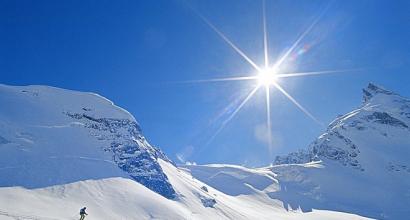
Not far from the border with Finland there are several beautiful lakes, and one of them, Triangular, is well known to many novice mountaineers. The lake itself is quite small, about 100 meters across, but next to it there are several rocks that climbers use for their training. One of these rocks is located directly on the shore, and rises like a sheer wall above the lake, and from the top there is a good panoramic view of the surrounding area.
There are many small parking lots here. And at the neighboring Novoselsoye Lake, 100 meters through the forest, there are also a couple of clearings. But despite the fairly large number of places for tents, sometimes there are difficulties in finding free ones due to the great popularity of the place. The neighboring lake is much larger and is of interest more to fishermen than to those who love beautiful scenery. Not everyone decides to swim in these lakes; the water is muddy and the bottom is clay and silt.
The entire area is rugged with paths, which is perfect for walking. However, there are no trails to the top of the main rock, and non-climbers will have to find a convenient climb on their own. It is most convenient to look for a hole to the top from the back side, where the rock is most gentle, but even here you will still have to climb over the stones.
How to get there: In order to get here, you must first of all take into account that the lake is located in the border zone. It is safest to have a visa, or arrange a tourist pass in advance. You can do this by submitting a completed application with a copy of your passport to Shpalernaya 62 (entrance from Kavalergardskaya Street), and in a month you will be given a pass (information for 2017).
Having finally received a pass, we drive past Vyborg towards Imatra. On the way, you will meet two border posts where cars are selectively stopped to check documents. This is where the pass comes in handy, without which they can turn you around if you get caught... And in the future it’s better not to take it too far away, as sometimes patrols go through the forests. Having passed the control, after Lesogorsky, we look for the sign “Losevo 1.9”, we go there. Having reached the 5-storey buildings, the main road will go to the right, but we need to go straight. Then the asphalt ends and 10 km of grader begins. At the first fork, with a gazebo in the center, we go right. After a few kilometers there will be a wooden cow pen on the left and a large field on the right. Immediately after this there is a barrier, before which you need to turn left. Again we drive a few km, and there will be a fork with a “minor road”, on which there is a sign “take care of the forest”. We're going right. Then immediately another fork: The main road goes left at an angle of 90 degrees, and the secondary road goes straight. Directly to us. Immediately there will be a third fork, here we go straight ahead again. After one and a half kilometers, at the next fork we go left, into the field... If everything is done correctly, you will see a sign for the Lietlahti farm in the field, we go further... Along the way you will also come across a log bridge and a steep climb with many stones. Having overcome it, there will be an impromptu parking lot where you can leave your car, then walking along the paths, we look for a clearing.
The Leningrad region is famous for its magnificent nature - forests, lakes and rivers. We can say that reservoirs are the hallmark of this region. According to scientists, there are more than forty thousand lakes in the vicinity of St. Petersburg. They all differ in size and history of origin. Most of them are located in the Vyborg, Podporozhsky and Priozersky districts. As a rule, they are of glacial origin, and therefore their depth is not too great.
Residents of the Northern capital love to spend their free time on the lakes. Magnificent nature, clean fresh air, exciting fishing attract city residents. These places are of particular interest to lovers of extreme recreation. This is easily explained: in the vicinity of the city there are picturesque Karelian granite rocks.
Ten years ago, the most visited areas were the Big Rocks and the Hiitola Rocks, located in the same direction. Since 2000, a young area located near the Finnish border - the cliffs of Lake Triugnoye, which has rapidly gained popularity among fans of rock climbing and bouldering in our country, began to actively develop.
Lake Treugolnoe, Vyborg district
To relax a little in the fresh air, enjoy the peace and beauty of wild nature, many residents of St. Petersburg go to the countryside. We invite you to take a short virtual excursion to Triangular Lake (Leningrad Region). It is located forty kilometers from Vyborg in the direction of Svetogorsk.
The triangular lake, a photo of which you can see below, is hidden from prying eyes and reliably protected by rocks. It is especially picturesque in summer. Here you can go fishing and admire its blue mirror surface. But most tourists, especially in recent years, prefer to come here to practice their favorite sport - rock climbing.

The massifs surrounding Triangular Lake have turned into a real Mecca for lovers of active pastime. The rock massif is located almost on the Finnish border, in the northern part of the Karelian Isthmus. Picturesque nature and a large number of interesting trails for beginners and professionals attract everyone who dreams of conquering mountains and rocks.
This massif surrounding Triangular Lake was discovered quite recently (2000) by Vladimir Molodozhen and Konstantin Beketov. In 2001, the first routes were already laid here. According to experts, the potential of this area is enormous. Rocky massifs with a huge number of paved trails, plenty of parking places, no problems with water - what could be better for active recreation?

Weather
The ideal period for visiting the Leningrad region is from July to August. At this time, the air warms up to +28 °C, and the water in the lake - up to +26 °C. Climbers prefer to go to these places in June and September. Experienced tourists believe that at this time the weather on Triangular Lake is more convenient for practicing their favorite sport, especially for bouldering and difficult routes, since the air temperature is 2-3 degrees lower.
In addition, they begin here in June. This feature allows climbers to train almost around the clock. Those who like to spend time outdoors should be guided by the long-term weather forecast - in early spring such a trip can be exciting.

Natural-ethnographic park
Lake Treugolnoye and the Lietlahti farm are part of a unique complex. According to the idea of the creators of the natural-ethnographic park and at the same time the owners of the farm - the spouses Jean and Olga Grazhulis, the project provides for several development vectors:
- amateur and sports areas;
- rural tourism;
- local history and ethnography;
- construction of carpentry, joinery, stucco and pottery workshops;
- creation of a camping center.
In articulating the park's concept, the Gražulis argue that it is an efficient way to approach land use. The main goal of the complex is to provide guests with the opportunity to delve into the history of these places and communicate with nature.

A little history
Until 1940, the name Lietlahti was borne by a village located near the small Fortress Lake. Today it has a different name - Triangular Lake. The first houses in this area appeared in 1635. By the beginning of the 20th century, in the village of Lietlahti (Kirva parish of the Principality of Finland) there were about twenty-five houses.
Later, this territory was included in the Russian Empire, then (after 1917) it became part of independent Finland, and in 1940 it became part of the RSFSR.
Lietlahti today
Today it is a natural and ethnographic park, which began to be created in 2008. At the same time, work began to restore the farm of the same name. The territory of the current park corresponds to the area occupied by the village of Lietlahti.
Currently, guests have at their disposal a large house that can accommodate thirty-five people at a time. On the territory of the farm there is electricity, water and gas supply, Wi-Fi, a toilet and a bathhouse. There are 268 trails in the park. In 2015, two new sectors for rope climbing were mastered - routes for beginners and the rather difficult Incorpi sector. The Triangular Lake massifs are within walking distance from the Lietlahti campsite and the main house.

Routes and rocks
The rocks of Triangle Lake are unique. They differ from other Karelian massifs in their huge variety of relief. Here you can see “ram’s foreheads” with sharp liabilities and minuscules, large vertical cracks, overhanging slabs, and internal corners. Inexperienced climbers have a place to work on their skills: more than twenty routes have been developed for them. Below we will present you the most popular of them.
"Right Crow's Nest"
A uniform and long route, with a rollout into the “nest”, rest in it and exit to the top. Even the existing dugouts in the middle of the route do not spoil the overall impression.
"Prophetic Oleg"
A route laid out along “ram’s foreheads”, liabilities and minuscules. The route is smooth and of average difficulty.
"The Kid and Carlson Castaneda"
An excellent route with only one drawback - its short length. It will require self-control and attention from the athlete.
"Pine"
This route starts on a sloping platform, then follows a key transition from a sloped shelf to a vertical gap. The transition is not clearly expressed, it is necessary to find a clue. You can try to do this several times, returning to the shelf to rest.

"Pisu Pis"
All routes are very different: from the shortest bouldering routes - up to 12 m, to long ones designed for endurance - up to 25 m, with difficulty from 5c to 8c. The routes have a wide variety of inclination angles, from “lying” to strong overhangs, and they often change their inclination angle.
The Northern White Nights allow you to do two training sessions a day. Usually the first one starts at 10.00 and lasts until 15.00, and the second - after swimming in the lake, lunch and day rest from 21.00 to 24.00. Most of the cliffs face south. Therefore, even after prolonged summer rains, they dry out very quickly in the sun, with the only exception being large cracks. And on some tracks with strong overhangs you can train even in heavy rain.
Accommodation
In recent years, most tourists prefer to stay in Lietlahti Park. Here you will be offered comfortable accommodation in a central house or in a campsite. All premises are provided with electricity, water, and there is a kitchen for cooking with all the necessary utensils. There is an excellent bathhouse on site. Free parking is available at the house.

And those who like a more romantic holiday can settle on the shores of Triangular Lake in a tent camp. The only condition that should be strictly observed when creating your own camp is not to occupy the parking areas of various communities and mountaineering clubs. The entire area around the lake is under official, documented lease from the Winner company.
You cannot drive directly to the parking lots by car; you must follow the path. This should be taken into account when traveling with small children.
House Rules
As Triangle Lake becomes more and more popular every year, experienced tourists and climbers are urged to follow the rules of conduct. They are quite simple:
- do not leave trash behind;
- watch the fires;
- bury toilets;
- do not dump household waste and chemicals into the waters of the lake;
- Do not leave inscriptions or drawings on rocks and trees.
Communication with border guards
The triangular lake with rock formations and Lietlahti Park are located in the border zone. All guests are encouraged to treat border officials with respect. Sometimes they come to parking areas or you can meet them on the trails. As a rule, a polite and friendly conversation ends with a check of documents.
Climbers with a pass are allowed to:
- stay unhindered in the reserve and border zone;
- break through rocks and relax on the lake shore;
- to fish.
Registration of a pass
The border zone, in addition to the lake, rocks and park, also includes the section of the road on which the border checkpoints are located. When transiting or staying in the border zone, a pass is required. To date, not a single case of failure has been recorded for climbers. The document is drawn up without any questions, however, the procedure is delayed for 30 days. Therefore, you should take care of this in advance by ordering documents in Vyborg or St. Petersburg, and pick them up on the way to the rocks. This service is free.

Triangular Lake how to get there?
Below we will present you with the available methods that will allow you to get to Triangular Lake, and you choose the most convenient for you.
From St. Petersburg you can get to Vyborg by local electric train, then transfer to a regular bus.
You might want to consider driving to Triangle Lake. How to get there? The route is as follows: St. Petersburg - Vyborg - Lesogorsky - Losevo - rocks and lake. The road through Vyborg along the Priozerskoye Highway, passing the village of Svobodnoe, and then to Topolki will take you an extra three hours of time. Moreover, the road itself cannot be called ideal. Therefore, many people prefer to travel by train.
1. To get to the bypass road of the city of Vyborg, it is recommended to take the Scandinavia highway. You pass the junction to Vyborg (we are going not to Vyborg, but to Helsinki), then skip another junction and turn at the junction where there are turns to Vyborg and Kamenogorsk/Svetogorsk/Lesogorskoye. After 1.5 km there will be a border post (the post has been closed for several years, although the border zone has been officially restored). Further along the road to Kamenogorsk/Svetogorsk/Lesogorskoye (main) 9.4 km to the sign “Kamenogorsk - straight, Lesogorsk, Svetogorsk - left”. You need to go left. The fork is very large, triangular. After 37.6 km there will be a railway crossing. After another 3.7 km you will see concrete bus stops (on both sides of the road). This is the turn to the village of Losevo and the village of Topolki (from the border guards to the turn 41.3 km, from the crossing - 3.7): turn right before reaching the right bus stop. The road you turned onto before joining the main one branches so that the bus stop is on an island. After 100 meters there will be a billboard with the picturesque inscription “Losevo”. Follow this road for 2.3 km to a village of 6-8 five-story buildings. Already in the village there will be a fork: a good asphalt road goes to the right, straight up the hill past the five-story buildings (they will be on the left) there is a road along which you need to go. Along the road you go to the outskirts of the village, to the beginning of the dirt road (2.4 km from the stops). The primer initially goes downhill. Local residents know this car path as the road to the village of Topolki. Everywhere you go along the main road. After 3.1 km there will be a crossroads, an equivalent road adjoins your road on the left, a field on the right and behind the field a forest and a lake. Go straight. After another 3.3 km the road forks. On the right there is a field, in the distance there is a lake, a house, behind the house there is a forest. The road goes straight to the house, you take the main road to the left. 12 km from the start of the dirt road, the road, after going downhill, makes a sharp turn to the left (the road is even inclined) and a slightly less noticeable road goes straight. At the fork in the road going straight there is a sign saying “hunting farm”. You need to go straight along the secondary road (the main road goes to Topolki). After 1-2 kilometers the road will reach a field. Before the field, a minor road goes off to the right. We have to go straight across the field. After the field there will be a stream that needs to be forded, and after the ford there will be a very bad road. If you really feel sorry for your iron horse, then you can leave it here. Although usually everyone slowly crawls all the way to the lake. It is about 1.5 km further to the lake along this road. It is impossible to drive through the lake and rocks.
2. The rocks of Lake Treugolnoe can also be reached along the Priozerskoye Highway. In terms of distance, it is even a little shorter, but you are unlikely to save time due to the greater congestion of the Priozerskoye Highway and the quality of the road. However, if for some reason you are driving along the Priozerskoye Highway, then you need to turn after the Losevo village after about 10 km to the left to the Melnikovo village (before the turn, 200 meters on the right there will be a wooden church with a blue dome). In Melnikovo, turn onto Borodinskoye (in the center of the village there is a square with a roundabout - the last turn). On the road to Borodinskoye there is a section of the road about 3 km on which there is no asphalt. Be careful and do not speed! In Borodino, after passing the railway crossing, immediately turn left onto Svobodnoe. In Svobodnoye the asphalt ends. If you have an SUV, then immediately after the asphalt in Svobodnoye ends, you can safely turn left straight onto the road leading to the rocks. Otherwise, we recommend that you make a “loop” through the village of Topolki. To do this, we go straight to Svobodnoye. Then at all the turns in the road we turn left. This way we will get to the turn with the sign “hunting farm”. For further description of the road, see above.
Near the lake, before a small descent, there will be clearings on the left and right where you can leave your car. Keep in mind that on summer weekends there can be a lot of cars here, but there are few clearings. Do not park your car across the entire “parking lot”.
3. If you don’t have a car, then the best option would be to come to this place by taxi from Lesogorsk. Local taxi drivers already know this place. You can get to Lesogorsky by bus from Vyborg, and to Vyborg, in turn, by train. Some people take a taxi directly in Vyborg. Large companies take a minibus as a taxi in Vyborg. We immediately advise you to agree with the taxi driver so that he will pick you back “on call”.
Triangle Lake

Schematic view from the main rock mass
The Triangular Lake massif entered the Russian climbing scene when it became clear that most other rocky areas had already been climbed, and inquisitive minds were still hungry for new discoveries. It turned out that there is an array that until recently was hidden from the public eye (until they began to actively cut down the forest in the vicinity, and the secret became apparent). The beautiful landscape and many interesting routes of varying difficulty levels make this area very attractive for rock climbing fans.
The potential of this area is enormous. Rocky massifs with a bunch of broken trails and even more that have not yet been broken. A large number of parking spaces, no problems with water, there is always an excellent climbing company. You can swim, you can dive. The downside, of course, is just the terrible last piece of the road, but it used to be even worse, every year the road gets worse. The difficulty of the trails is from 5a to 8c, all the trails are interesting and varied. The material itself allows you to go through the routes in different ways and find something for everyone.
How to get there
Coordinates:
Latitude, longitude:61.109913, 29.1602898
Degree decimal:61.109913N 29.1602898E
Degree, minutes, seconds:61°6"35"N 29°9"37"E
explanatory description: http://c-f-r.ru/rocks/area/treugolnoye
reprint of outdated description: http://ludi-skal.ru/?mod=climbarea&p=area&id=17

To Vyborg by any means - by train/train/bus (from St. Petersburg metro stations Parnas and Devyatkino), after 21:00 public transport on the Vyborg - St. Petersburg section stops working, by car. From Vyborg in the direction of Svetogorsk/Imatra. Bus (to Svetogorsk several times a day)/taxi/bicycle (about 40 km) or other transport..


Accession from Kamennogorsk
We turn left onto Lesogorsky, this is the route to Treugolnoye via Losevo (you’ll get there faster and easier).
The road to Kamennogorsk is straight, if you don’t turn anywhere, then join the previous route in Lesogorsk. You can go to Borodinskoye/Svobodnoe in Kamennogorsk - you will take the route from Priozersk (more difficult for transport).


5.3 km Gazebo. We leave it on the left, on the right through the lowland you can see the lake (I think Voroshilovskoye)
8.7 km Private territory. A beautiful landscape on a hill: right there is a field, a house, a forest behind the house, a lake in the distance. The road goes straight to the house. [It directly beckons you there)))] Barrier (((and the sign “Private territory”. The main road goes to the left. You - to the left!!! Along the main road. (After 3.3 from the beginning of the dirt road)

14.5 Turn. The main one turns 90 to the left (presumably it goes to Topolki) the road is even inclined. A slightly less traveled road straight ahead. You need to go straight along the secondary road. (12 km from the beginning of the dirt road)
16.6 km Cottage. After 1...2 km the road will come out into open space; on the left there will be low, sloping granite foreheads. Big brown cottage.
16.9 km Quarry. On the right is a small sand pit.
17.2 km Bridge with boardwalk under the track in the swamp.

After it there will be a very bad road for cars. After rain, water accumulates in the ruts. About a kilometer before the lake, clearings for parking for thrifty people will begin to appear. 17.9 km Parking lot1

parking 1
18.3 km Pipe

Before the slight descent, there will be clearings on the left and right where you can leave your car. Then you follow the road downhill. At the very bottom on the right, a lake approaches the road from which a fast and noisy stream flows to the left into a triangular lake.
- This is the middle place of the Rocky region: Triangular (Leningrad region). [
Main rock mass. Take the path to the left along the stream and then around the lake to the opposite bank. This is a site for local aborigines!!! Sorry! There are no free places; tent sites usually all belong to someone. So, please choose a parking spot somewhere far away (in general, all convenient parking spots near the rocks have already been taken, apparently, you need to look for free ones on the neighboring lake). Up towards the rocks and slightly to the right, 150 meters.
You can also get to Triangular Lake through Borodino and Svobodnoye. The road from Svobodny is noticeably worse than from Kamenogorsk; not every car can be driven.
- Interactive map on maps.google.com
- Track for Garmin through Vyborg
- Track for Garmin through Priozersk
Border zone on the road to Kamenogorsk
The rocks are located in the border zone. To enter the border zone you must obtain a pass. Passes are issued in St. Petersburg at Shpalernaya 62. Submission of documents - Tue., Thu. 15-17. Inquiries on working days 10-12, 14.30-17.30 by phone. 438-64-58, 578-04-48. To obtain a pass, you need a photocopy of your passport with registration and an application filled out on site. In the application we honestly write Purpose: Rock climbing, area: lake. Triangular (Lesogorsky settlement, Svobodnoe settlement). It takes a long time to make passes, about 20 days. In addition, there is a border. branches in Vyborg and Svetogorsk. It’s also possible to travel with a Schengen visa (it’s like we’re going to Finland). But keep in mind that with a visa you have the right to travel only “by the shortest route to the travel point.” There have been cases when border guards stopped cars on a dirt road and turned them back home with a Finnish visa. Travel certificates, as in the old days, are not valid. If you are “traveling to the Svetogorsk pulp and paper mill for work,” then you need to apply for a pass in advance, attaching your travel document to the application for the pass.
However, at present (2009) there is no checkpoint on the road through Svobodnoye. There you can safely drive straight even to the Finnish border.
Guidebook
Sector A

| 1 | Left crow's nest | 6a | 20 m | 8 from | Chain |
| 2 | Right Crow's Nest | 6b+ | 20 m | 10 from | Chain |
| 3 | 7? | 20 m | Chain | ||
| 4 | 7? | 20 m | Chain | ||
| 5 | Unusual | 7a | 20 m | 9 from | Chain |
| 6 | Rowan | 5c | 20 m | 10 from | Chain |
| 7 | Unfinished Pioneer | 6b+ | 23 m | 10 from | Chain |
| 8 | 7-8? | - m | Chain | ||
| 9 | 7-8? | - m | Chain | ||
| 10 | 7-8? | - m | Chain | ||
| 11 | Nose | 7b+/7c | 25 m | 10 from | Chain |
| 12 | A climber's dream (project) | 8a+? | - m | 15? from | Carbine |
| 13 | project | 7c? | 20 m | 10 from | Carabiner on chain: no 3rd bolt |
| 14 | Brain | 7b/7b+ | 20 m | 12 from | Chain |
| 15 | Pine | 6b+ | 20 m | 12 from | Chain |