Climbing the sacred mountain Munku-Sardyk. Report on the ascent to Munku-Sardyk Trekking to Munku-Sardyk in summer
(all photos were taken with a phone)
I have a cousin who is a climber. The last time we saw each other was 20 years ago, when the brother was not yet a climber, but was a double bass and passed through Saratov from another hike with a walkie-talkie and a machine gun on his shoulders in the Chechen Republic. There he earned himself, besides a reduced fare on the certificate of a participant in hostilities, some metal brackets in the spine, after which, in order to strengthen his back, he took up rock climbing first, and then mountaineering. She also runs marathons sometimes. Although we did not see each other, but, the stump is clear, thanks social networks communicated. Several times he called me with him to the mountains, then to Elbrus, then somewhere else, but something somehow did not grow together. This year he offered to go with him to "conquer" highest point Eastern Sayans - Mount Munku-Sardyk in Buryatia. This time I signed up. This decision was facilitated by the brother's assurances that Munku-Sardyk is a mountain for suckers, without categories, so it will be easy for me to climb it.
In general, now I will share my impressions. A number of travel agencies lead tourists to Munku-Sardyk in an organized manner, so my writings, perhaps, will help someone make a decision to go or not to go.
But first I will say that I have never been a climber. From words in general and completely. The physical form is not the worst, but specifically leaves much to be desired. Favorite physical exercise - back support lying on the sofa with a laptop on his stomach. AT hiking went in distant childhood and already forgot how it's done. If I knew what kind of fizukh it would be, then I would not agree to life. In general, in the phrase " leisure”, regarding this event, the word “rest” is clearly an extra word. Everything that I will write below is the essence of the impression of a teapot that first hit the mountains, so professional hikers and climbers can safely leaf through my writings, because it will be boring for them.
In short, my task was to get to Irkutsk, with minimal equipment and clothes suitable for this purpose, where my brother and comrades were supposed to pick me up by car, take me to the Tunka Valley, to the mouth of the White Irkut, from where the ascent was actually supposed to begin. Yes ... about a month before the trip, passes were received to the border zone, because Mount Munku-Sardyk is not just located in it, the border with Mongolia passes just along its top.
Impressions began immediately upon arrival, when I saw what to go.


Desperate people drove on this pepelats right from under Yekaterinburg. By the way, this is food for thought for those who whine that his life is boring, but there is no money for adventures. This device, I think, costs a little more than the price tag for the Moscow-Irkutsk-Moscow flight. And with the help of it, people traveled half of Russia to Buryatia, and then they will go to Tuva, through Khakassia, climb Mount Mogun-Taiga, and then back to Yoburg, spending the night in a tent and eating a meal cooked on a gas stove. Yes... a rather specific pastime (far from Egypt with all-inclusive), but certainly not boring. The path lay through Slyudyanka (a town on the shores of Lake Baikal), but the “glorious sea” was not particularly impressive.


It was dog cold, Baikal was under ice, the coast in the Slyudyanka area is not very picturesque, at least at this time. The Tunkinskaya Valley itself turned out to be much more picturesque, which the Buryats declared as a whole national park. This meant that you had to pay money for entry (I think 100 rubles per person). I want to note ..., despite the fact that in fact the area where we were going was a hole in a hole, the quality of the roads was very decent. Comparing to Saratov region(Europe, blah!) I can say that the roads in Buryatia will be steeper.

Mount Munku-Sardyk is considered sacred by the locals, in connection with which a significant number of leaflets are stuck in the vicinity, calling for the ascent to be abandoned. The Buryats themselves, it seems to me, are more than indifferent to this. In early May, a mass ascent of all comers begins on Munka, called the mountain festival. At this time there is not overcrowded with people, which is why we arrived there a few days earlier.


(this is where the trail starts)
When I saw how much equipment was being unloaded from the car, mentally divided it by the number of participants in the campaign, I was already somewhat depressed. A night in a sleeping bag and a tent, on which snow fell by nightfall, as well as a morning wash in a cold river, somehow did not add optimism either.
In the morning, when we scattered equipment and food in backpacks, it turned out that we would have to carry about 30 kg. The brother, as the leader of the sortie, dragged a 120-liter backpack, which, according to my estimates, weighed about 40 kg. This despite the fact that he himself is 65 kg. weighs.

The path to the mountain passes through the ice of the frozen bed of the Bely Irkut River. According to the map, from the bridge across Bolshaya Irkut to the top is about 9 km. In reality, taking into account the zigzags of the walking path, it is about 14 km. For students in the Soviet high school, I’ll add: the distance on the map is the essence of the legs, the second leg will be the elevation difference from the level of the starting point to the top, and therefore the conditional hypotenuse in the form of a rise will be a few more kilometers more. But it still doesn't reflect reality. While the rise was more or less smooth, it was somehow still tolerable, but then, blah, pebbles began, along which it was necessary to climb up. Climb sometimes. 


Very soon I was covered in soap, sweat climbed into my eyes, mixing with sunscreen, and my tongue fell out on my shoulder. From the loss of face saved only complexes. There was an aunt in the group who pearled exactly the same backpack with a straight face. Requiring rest stops and being too blatant about my physical o…e was a bit creepy. After 6 hours, when I was already tired of getting tired, my brother gave the command to put up a tent and settle down for the night. I stuttered so much that after eating I got off in a moment, despite the tea with sagan-dajlya (http://etochay.ru/etnicheskiy/dolgoletiya-sagan-dajlya.html), which we kicked on the way. However, given the 5-hour time difference with Moscow and acclimatization, x / s that tired more.


The next day, we had to climb to the very top. They left all the junk in the tent, they took with them only warm clothes in backpacks, a thermos with tea and safety harnesses. We left at 8:50. As before, if I knew how far to go and on which road, I would definitely merge. Fortunately for me, I did not imagine this, and the prospect of not having a heavy backpack when climbing inspired false hopes.


Ass! We had not yet reached Lake Ekhoi, as I already wanted to go back to the tent, I was again in soap and with my tongue on my shoulder. The brother, apparently forgetting that there is a weak link in his group, set a very vigorous pace (he is the only one carrying a heavy backpack with equipment “just in case”). As a result, on the way to the top, almost no one overtook us, with the exception of a pretty young lady in some fashionable equipment, who, like a tractor, pushed past us uphill and met us at the top, already descending from it. By the lake (it was covered with snow) there were several tents and people were hanging out. The wind has begun. I had to get snowboard junk and warm up. The path that the previous climbing comrades had trodden was swept up, so we had to climb almost knee-deep in snow.


Gradually, the hill became steep, if it were not for the crampons on the boots, the legs would have begun to slip specifically. Extreme meters 150 (by altimeter) became generally cool, and then quite cool. It was already necessary to climb, using all four moslas. The problem was also that citizens who had already been on the top periodically descended from above and it was very inconvenient to disperse with them. Somewhere in 30-40 meters from the peak, a dude was caught, who was stupidly lying on the stones, like a fish taken out of the water. He was so tired that he could no longer climb up. Potz said that, like me, it was his first time in the mountains, and in terms of obscene language, he wondered how the hell he had given up. As a result, he climbed a little later to the top and jumped there like a bunny. As for me, about 80 meters from the top, the body, apparently realizing that it would die soon, turned on the turbocharging, so I climbed quite easily. An interesting detail... All the climbers we met politely greeted us (and we, of course, with them). Climbing to the top, I seem to have caught up with the meaning of it. This is not just politeness ... it really takes a lot of health, so wishing it once again to the oncoming one is the right thing to do. Looking ahead a little, so that some readers don’t feel sorry for me so much, I’ll say that neither my legs nor my shoulders hurt after this outing and didn’t even get rubbed. The main problem is the breath and back, because, as I said before, a 100-liter backpack has never taxed in my life, shamefully evaded deadlift.

We were very lucky, because after 20 minutes, after we had risen, the clouds were a little bit blown away by the wind and we had the pleasure of seeing Khubsugul Lake, located on Mongolian territory, from above. Unexpectedly, the cellular connection started working for me (the phone was offline for the third day), so it turned out to show off in front of everyone I wanted to, directly from the place.


It was much easier to go back down, the stump is clear, except for places with a very steep slope. In these areas, going down was harder than climbing up. We returned to the tent 11 hours later, from the beginning of the exit.

The next day, having collected junk and a tent, we went down from the "circus", where we camped to the confluence of the White Irkut and Muguvek (the so-called "strelka"). There were already crowds of climbing and tourist people, there were heaps of tents and even magnets were sold.

We put up a tent, after which the bro solemnly announced that since the weather was bad, we met the ascent in a short time, BINGO!!!, bonus game! "BLAAAAAT!!!" - I thought, for I was already fed up with walking in crampons and a helmet. I languidly tried to offer an alternative, in the form of an extra day on the plain with beer and a bath, but I was in the minority. In short climbed to Obzornaya. Only the fact that we left the camp after lunch and, directly, at the foot of the mountain where this stone stands, saved us from the decisive breakthrough (however, the hill looked more like a hill) too late. 
The slopes were covered with concrete mud and snow began to fall. After evaluating all the pros and cons, we decided not to climb, which I was incredibly happy about.
On the way back (down), both this day and the next, somehow it was better photographed.


After spending the night on the “strelka”, we went down to the bridge over the B. Irkut, where we left the car, after which we moved to Arshan (local resort). When we left, there were already huge crowds of people who came to the festival. The space under the bridge was densely packed with cars.

Before I describe the last couple of days in Buryatia, I’ll say a few words about Putin’s notorious fighting Buryats (cat. PTN PNH), who, according to Svidomo’s statements, were fired ... or they were under some kind of Ilovaisk.
I declare with authority that they exist. Many, maybe not the same ones, of course, I saw in the vicinity of Munku-Sardyk. They are of two types. The first are Buryats with machine guns and in camouflage - border guards, who have checked our passports and passes to the border zone 5-6 times for all the time. The second ones are crowds of people in climbing equipment, pushing hefty backpacks uphill, absolutely on a voluntary basis, without any coercion and deceit. Among them were both minors and clearly elderly people of both sexes. Even grandfathers were bearded. Some, in addition to a huge backpack, also dragged a snowboard or skis up. Unlike me, it was completely normal for them. People obviously enjoyed such outings.
In general, I would register such people in the military registration and enlistment offices, as they used to do with personal vehicles, in case of mobilization. For a close-knit company of climbers who climb mountains with 40 kg. -mi backpacks, spend the night in the snow in a tent and cook at the stake - this is a ready-made sabotage and reconnaissance detachment, you just need to train them a little in explosives, handling weapons and captive languages.
“Only mountains can be better than mountains…. Which I haven't been to yet." Even if someone does not know this song by Vladimir Vysotsky completely, then many have heard and quote these lines. And lovers of the mountains, even more so.
We dream of conquering the peak that has already conquered us. This time we failed, but the irresistible desire to return and try again is deep in the heart and is just waiting in the wings to break free.
Munku Saridak is a natural artifact.
Munku Saridak (popularly we call it Sardyk), the highest point of the Eastern Sayans. At an altitude of 3491 m, she comfortably settled down on the border of Mongolia and the Republic of Buryatia. The path to the summit stretches through mountain icefall, steep climbs, deep snow and unpredictable rockfalls. The path to the top is marked by dangerous surprises, but tourists who are in love with the mountains, people who want to test themselves, understand what they are capable of, experience a sense of freedom, flight and unconditional happiness, come here again and again. Having not reached the top once, they repeat their ascents annually.
Climbing route to Munka Sardyk
Climbing Munka usually starts from a place called "Arrow". Why "usually"? Because there are two options for climbing: correct and not very. We chose the "not very correct" option. We decided to reach the summit at 3491 m immediately from 1500 m. Without thinking that the body needs to acclimatize at least every 1000 m. Therefore, the correct option is two overnight stays: one on Strelka (1500 m), the other on Lake Ekhoy ( 2600 m). But spending the night in a tent when it's minus 20 outside is also a certain kind of adrenaline. Therefore, we decided to take a chance, but only not to sleep for two nights in a cold, frozen tent.
The arrow is located at an altitude of 1500 m above sea level. Along the channel of the White Irkut, on the right side, there is a forest, in which all the tourists are accommodated in the clearings for the night.
It is worth leaving the Strelka for the ascent early in the morning, from about 6-00 to 8-00.
And the first dangerous and difficult obstacle is the icefall. 
Here we put on crampons, helmets, pick up an ice ax and ... forward. 

The water, overgrown with a gentle, greenish-blue color, has created just a huge ice mountain with steep springboards. 
Looking back, you think about the path you have traveled, if you suddenly slip ... probably there will even be nothing to collect below. Therefore, an ice ax and crampons when overcoming an icefall are our everything. 
Another danger is rockfall. From under the feet of tourists who have gone ahead, the trail crumbles and stones fly down at breakneck speed to those conquerors who go slower or take the route later. So a helmet is safety.
Having overcome the icefall, it becomes a little easier to go. The endless expanses of the plateau, surrounded by mountain ranges; the blinding sun reflecting off the snow with millions of sparks. Here the splendor of nature is felt with greater force. 
We overcome two steep ascents and exit to Lake Ekhoi.

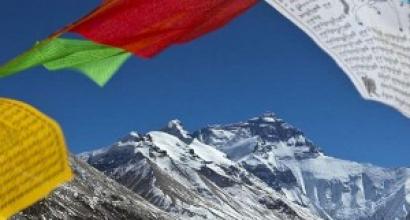
Only here, on the lake, Munch appears before us in all his grandeur and stature, cutting through the blue of the sky with his top. Forever white char - this is the name of the peak in translation from Buryat. Strict, serious and seemingly impregnable. It seems that you are not conquering her, but she is thinking who to let in and who will come next time.
Menacingly harsh and so magnificent in her silent existence. Oh my god, I think I'm in love! It looks like everyone is in love here! 
On the lake, usually everyone has a hearty dinner, relax to the maximum, gain strength, turn on a second wind (or maybe someone already has a third or fourth). 
We cross the lake straight ahead and there are two steep climbs to the pillows ahead. 
You have to climb through the snow, but if a regiment of tourists has passed in front of you, then there are already steps from the boots, so it’s easier.

The first pillow has been overcome. Ahead is the second.
And then ... all dreams collapsed overnight.
My faithful companion had a mountain rash.
Who does not know about such a disease, and we also did not know anything about it until this moment, then it is, if in a simple way, difficulty in breathing. It becomes difficult to breathe, it is impossible to take a breath, heart palpitations. In short, you have to get down.
I honestly admit that when you see the top, you lose a little sense of reality. It is very difficult to say to yourself: “That's it, your path to the top is over this time. You will come here, but it will be next time!”. It is very difficult to accept this, to realize that this happened to you. Just tears welling up in my eyes. A serious struggle is going on inside: to continue the journey and leave a fellow traveler, or still remember that there is nothing more important than human life and health, that a friend is known in trouble. As in another song by V. Vysotsky: “Take a friend to the mountains - take a chance. Don't leave one - him!"
I have to get myself out of this narcotic state. Are you looking at this unconquered summit, standing motionless in the rays of the midday sun, and you think: “What a pity, but apparently not this time!”
So without conquering, we went down. But I will definitely come back next year.

Cats, helmets, a jacket and other property stick out of the backpack: there is no strength to put everything back into the backpack)) We go down ...
Well, those who can go further will have to overcome one more steep climb (this is after the second snow cushion) and reach the finish line - the ascent itself. Here you will need a rope and a carabiner, crampons and an ice ax. Who will not, that is, there is a risk that the Ministry of Emergency Situations, who are on duty in the mountains, will turn you around and send you on your way back. When we went, many descended without conquering for this very reason: there was either an ice ax, or crampons, or a carbine.
How to get to Strelka - before the start of the ascent.
We leave Irkutsk - Mondy along the Shelekhov tract, towards Kultuk, then turn to Arshan, Zhemchug.
Distance - 304 km. Travel time by car from Irkutsk is approximately 3.5 - 4 hours.

Bridge exit. We leave the car here
We enter Mondy through the border checkpoint (read below how to get permission to enter the border zone), drive through Mondy and immediately after the village (there is a sign) turn right into Orlik. We drive on a gravel road for 20 km. We reach the bridge across the Irkut and turn right right under the bridge. Here you can leave your car. Further - on foot.

ready to go)
We walk along the ice-covered channel of the White Irkut, among the overhanging rocks and mountain ranges, about 1.5-2 hours to the Strelka. 
Straight all the time. There are a lot of people on the May holidays, so it’s hard to get lost, as everyone goes in one direction. On Strelka in the middle of the forest you can set up a camp. There is firewood and clearings where you can set up tents for the night.
On this segment, a good business is developed among the local population: your backpack will be taken on a quad bike to Strelka for 300 rubles. You can also be dropped off at the same rate. 
Of course, you can not go, but go, but do not deprive yourself of the pleasure of walking along a frozen river, where melted waters murmur in places in the thawed patches.
The panorama of the picturesque gorge, where the waters of White Irkutsk are about to run after a long Siberian winter, is breathtaking. Rocks hang right overhead, and from the surrounding terrain it is not difficult to guess that landslides and rockfalls are not uncommon here.

White Irkut Gorge
What to take with you on the ascent of Munku Saridak and other tips.
From things:
- tent;
- a sleeping bag for a temperature of minus 20;
- primus stove (or burner);
- not blown jacket and not blown pants (there is an icy wind on the lake and there is nowhere to hide from it). Those who were at the top say that there is just a heavy wind that can take you to Mongolia, be careful 🙂
- waterproof shoes (better trekking, winter);
- mittens or gloves (plus spare ones);
- podpopnik (necessarily, you will see what is useful);
- sunblock or a bandage that will cover the face.
- Sunglasses
Equipment:
– cats (can be rented);
- ice ax;
- helmet (required, strong rockfall);
- ski or trekking poles.

All my belongings do not fit into the car, I have to cram it 🙂
Tips (you can not use it, so, for information in general):
1. The face must be smeared with a thick layer of cream. Do not smear the cream on the face so that it is not visible, namely, put a layer on the face. Snow reflects the sun's rays and everything that is not smeared or uncovered simply burns. We saw charred (not tanned, namely charred) faces - like from horror films.
2. It is advisable to wear shoes that have already been worn (not new). In new shoes, there is a high probability of rubbing corns, and this will inevitably lead to a return to the halfway point.
3. If during the ascent you feel that you feel bad, there is a rapid heartbeat, dizziness, it is difficult to take a deep breath, shortness of breath - it is better to go down. The Ministry of Emergency Situations works on Munka Sardyk during the May ascents and they, of course, let down those who feel bad. But in my opinion, it is better not to bring it to a critical state and to refuse further ascent, since it happened to health.
4. Climbing is considered the most correct (as the instructors working on this route say) - this is a gradual adaptation. The first night must be spent at an altitude of 1500 - on the Strelka.
Spend the second night on the lake at an altitude of 2600.
If you choose the right ascent for yourself (a health-sparing option), then be sure to take a primus stove (burner) with you. There is no wood on the lake.
Those who go to the top from Strelka in one day need a little physical preparation, no mountain climbing, and a hearty lunch on the lake.
5. A hearty lunch with hot tea is very important. Take a small thermos, sweets, energy-rich foods (nuts, for example) with you. Many had apples, bananas, etc. with them.
6. The decisive role in our negative result was played to a greater extent by the incorrect organization of the ascent for beginners (more precisely, its absence). For example, the organization of the ascent included lunch, but the organizer did not take it. And when all the other groups were drinking tea and admiring the views, we, tired, sat in the icy wind and drank ice water.
7. If you are going to go with an instructor, choose him only on someone's recommendation. While everyone was resting among the rocks, hiding from the wind and gaining strength, we, like mad, ran after the instructor, who really wanted to quickly run to the top. And besides, your safety is in the hands of the instructor. However, we were a little unlucky in this part and our instructor, having received 10 thousand rubles from us for our safety, left us almost at the top and went his own way. We went down alone, and the descent is much more dangerous than the ascent. In addition, the forces are already running out, because of which attentiveness, vigilance, balance are lost.
Therefore, I advise you to choose an instructor only on the recommendation.
8. In these places, you can not only conquer the peak of Munku Sardyk, but also just relax with family or friends, wander along the taiga trails, climb the Obzorny peak, see the confluence of the White and Black Irkut, collect wild medicinal herbs, and just breathe in the smell mountains
9. On the way back we stopped in - to lie down in the pool.
What time to go to Munch Sardyk.
The most crowded time of the trip to Munka Sardyk is May Day and May 9 holidays.
During this period, it is no longer so cold to sleep in a tent at night. And besides, you can get to the foot of the peak only along the bed of the Irkut. At this time, he is still hiding under the ice.
From the side of Mongolia, from Lake Khuvsgul, ascents are made all year round.
Are the services of a guide, guide, instructor necessary when climbing Munku Sardyk.
Price:
11 200 rubles
Duration:
4 days / 3 nights
Travel date:
- 04/30/2019 - 05/03/2019 (took place)
Description of the trip
The peak of Munku-Sardyk is located on the border of the Republic of Buryatia and Mongolia. From this peak, a stunning view of the Eastern Sayan Mountains and the famous Mongolian lake Khubsugul opens up. Climbing is a movement in bundles or with the help of an individual belay device (cats, ice ax, helmet, belay system) along a steep snow-scree slope of 35 degrees. A hundred meters to the top, the ascent is marked with special cables for individual insurance. Climbing from the base camp and back takes an average of 10 hours. The top of Munku-Sardyk is very popular and accessible to man with different levels of training, thanks to the well-coordinated work of the team and the professionalism of the instructors. On May holidays, according to statistics, more than 5000 people come to the territory of the border zone to climb this difficult peak. Accommodation is provided in the base camp at an altitude of 1800 meters. We tried to make for you the most comfortable conditions for rest before and after the ascent. Life in the mountains can be more comfortable than you think. Our camp is equipped with warm tents with heating, with a capacity of 10 people, electricity, the ability to charge your electrical appliances, and use the light in the tent and near the camp, we also install a field bath for our tourists, with hot and cold water. Cooks are prepared in the camp, so you won’t have to bother with duties, and camp assistants provide heat in tents at night, and you don’t have to think about providing firewood. They leave for the preparation of the camp a week before the ascent, the preparation of firewood, the provision of light, heat, a field kitchen, and snowmobiles. Age: from 12 years old (accompanied by parents). Important: pay in full for the trip and send your passport details for issuing a pass before April 14. For foreign citizens, the deadline for submitting data is two months before the start of the tour; payment is also due April 14th.Included in cost
- transfer from the railway station in Irkutsk and back- accommodation in winter tents with stoves
- services of a cook, assistants and guides
- meals from dinner on day 1 to breakfast on day 4
- field bath (capacity 10 people)
- use of group equipment and special
- registration of passes to the border area with Mongolia
- camp preparation and organization of its work
- registration in the rescue service
- medical support
Price not included
- air and railway tickets from and to Irkutsk- meals in a roadside cafe 2 times
- souvenir products
- special equipment helmet, ice ax, crampons, safety system (harness, self-insurance mustache and 2 carabiners) - 1000 rubles / whole trip
- transfer to the base camp of cargo by snowmobiles - 300 rubles
Program
Day 1.The length of the transition is 5.3 km, the climb is 300 m. Meeting in Irkutsk (railway station 8:00). We recommend arriving / flying to Irkutsk in advance, the evening before or at night. Introduction to guides. Transfer to the beginning of the active part of the route (360 km) - the bridge over the Bely Irkut River (Republic of Buryatia). During the trip we will visit observation deck, which offers a beautiful view of the southern tip of Lake Baikal and the Khamar-Daban ridge, sung by Vizbor. Further, our path runs through the territory of Tunkinsky national park Republic of Buryatia with its picturesque steppe landscapes and Buryat settlements. Along the Tunkinskaya valley, the peaks of Khamar-Daban and the Eastern Sayan rise majestically. Lunch at a roadside cafe. We also pass the Mondy frontier post, present the passes issued in advance and reach the starting point for another 30 km. Today we have to go 5.3 km, with a climb of 300 m. On the way we will meet the canyon of the river. White Irkut with its high walls. Our base camp (1800 m) is located at the confluence of the Bely Irkut and Muguvek rivers. Dinner. Overnight in tents heated by stoves. Overnight altitude 1800 m above sea level.
Day 2
The length of the transition is 15.3 km, the climb is 1100 m, the drop is 1100 m. Climbing is not technically difficult, self-insurance with trekking poles. From the top you can see the Munku-Sardyk ridge and the Oka plateau, where the majestic Irkut, Kitoy and Oka (Sayan) rivers originate. Lunch (snack). Descent from the top. Return to base camp. Dinner by the fire. Overnight in tents heated by stoves. Overnight altitude 1800 m above sea level.
Day 3
The length of the transition is 10 km, the climb is 1700 m. Breakfast. Exit in the direction of Munku-Sardyk peak along the Muguvek river. Sharp climb over the Muguvek icefalls, color blue ice bewitches. Then we continue the ascent to the mountain lake Ekhoi. Dinner. We put on and prepare special equipment: an individual safety system, a helmet, crampons, an ice ax. Note: the ascent may be canceled due to worsening weather conditions that put the health of tourists at risk (the decision is made by the instructor-guide). We continue climbing. From the top, which is 3491 m above sea level, a majestic panorama of Mongolia and the Eastern Sayan opens, one can clearly see the lake Khubsugul, covered with a shell of ice. Descent along the path of ascent, rest, lunch. Then we descend to the base camp.
Climbing Munka-Sardyk is not just climbing a mountain, it is a place where you get to know yourself and the world in a different way!
Tourist Club "TRIKONYA" invites you to take part in the ascent to Munka-Sardyk. The trip will take place during May holidays which is very convenient. And May is the most the best time for climbing Munka-Sardyk. The 4-day hike is designed for people with a busy work schedule. Optimal price and fast ascent.
For 4 days you will visit a real hike!


Making passes!
Munku-Sardyk is the highest point of the Eastern Sayan. Mountain height: 3491 m. The Munku-Sardyk mountain range is located on the border with Mongolia, so you need to issue a pass IN ADVANCE (one month in advance). We take care of all organizational issues.
Our club will give you all the necessary alpine equipment!
For climbing, you need to have alp equipment (cramps, ice ax, helmet and much more) - our club will give you this equipment for FREE, no additional expenses!

REQUIRED LEVEL OF PREPARATION!
For climbing, you must have an average physical fitness. Before hiking, you need to pay special attention to your equipment (boots, clothes). You must have good, high-quality things adapted for climbing. We will give advice on preparation before the trip.
After you sign up, you need to start running and walking a lot in order to prepare your body for this trip. Climbing from the camp to the top is about 1700 m of climb. In terms of time, on average, from the camp to the top with a return trip, the journey takes 12 hours.

Campaign group on VKontakte:
What is included in the price

- Meals on the route;
- Transfers on the route (from Slyudyanka)/li>
- Services of an instructor-guide;
- Climbing equipment (cramps, helmets, ice axes);
- Group equipment;
- Registration in the rescue service of the Ministry of Emergency Situations;
- Consultations before the trip from instructors-guides and organizers;
What is not included

- The road to Slyudyanka;
- Medical insurance;
- Personal expenses in roadside cafes;
- Bath in the city;
SELECTION OF EQUIPMENT FOR THE TRIP:
For a comfortable participation in the event, you need to responsibly approach the selection of camping items!
Personal travel:
- Backpack80-90L for women and 90-100L for men. Be sure to have a waterproof case with it.
- Sleeping bag. Comfort temperature -5… -10 С.
- The rug is tourist. Nice thick rug, from a specialty travel store. NOT a yoga mat!
- Backpack for radial outlets and ascents. The optimal size is 30-45 liters. It can be quite light, rag-like, without a hard back.
- Trekking poles. They allow you to take some of the load off your legs, facilitate movement, as well as ups and downs.
- Seat ("hoba", "podpopnik") For sitting on the ground, so that it is dry, warm and the pants are clean.
- Mug, spoon, bowl. Utensils should be made of stainless steel or special plastic. A fork is not needed. Glass or ceramic will not work!
Special climbing equipment
(all equipment must be certified):
- Ice ax
- cats
- Helmet
- strapping
- Carabiners 4 pcs, lanyard mustache 2 pcs.
Clothing:
- Windbreaker jacket. Lightweight windproof jacket with hood.
- Running pants. Lightweight windproof pants, preferably made of synthetics.
- Down jacket. For insulation in parking lots and halts. Can be replaced with a synthetic jacket. Must be warm!
- Pants are warm. For the camp, preferably with insulation and separately from running pants.
- Warm fleece jacket and pants. Additional insulation under a windbreaker jacket and running pants.
- Lightweight sweater and thermal underwear. For evening parking and overnight stays.
- T-shirt. You can take about 3 t-shirts. We recommend taking at least one with a long sleeve, or it will be a light shirt.
- Headdress. Panama, cap, bandana.
- Underwear.
- Socks. For walking - trekking socks, several pairs. Warm socks for the evening.
- Hat, gloves. A warm hat to cover your ears. Gloves are warm, and the second type of warm tops.
- Face protection from wind and cold (balaclava, trumpet, buff)
Shoes
- Velcro sandals (tourist) Those that do not mind getting wet, for fording (tightly fastened) and parking. You can also wear them on the train and in civilization.
- Bivy shoes. If the mountain boots are single-layer, then additional parking shoes, EVA foam rubber boots, will come in handy.
- Climbing shoes (trekking or climbing boots with or without welts). For a successful ascent, you need to have good mountain boots made of thick leather with a minimum of seams with a membrane or two-layer plastic ones. Boots should be comfortable, well-worn, waterproof, warm and one size larger. If the shoes are not of the highest quality, it makes sense to purchase and wear over shoe covers that cover the entire boot, make it much warmer and protect it from getting wet;
- Gaiters on legs for protection from snow;
Rest
- Documentation. Passport, medical policy, insurance (additional for the hike), money for personal expenses and unforeseen circumstances. Everything is packed in a sealed bag.
- Flashlight. Headband, with new batteries and a set of spares.
- Sunglasses. Mountain good (with UV protection).
- Water bottle. You can buy a special one, or a regular one from the store.
- Thermos for tea, for 1 person the volume is about 0.5 - 1 l.
- Protecting things from moisture. For things that are inside the backpack, special dry bags or ordinary garbage bags are suitable, take more, as they quickly tear.
- Personal first aid kit. Take: things that you may only need (for example, a certain antibiotic, etc.) or specific drugs that you use, and these are unlikely to be in the group first aid kit; something that is hard to take at all: colds; painkillers, anti-inflammatory ointments; antiseptics; wound healing; antiallergic; cardiac; antipyretic; antibiotics; a small plate of corn plasters, a roll plaster; a pack of activated charcoal, and other preparations for the stomach; elastic bandage; small bandage.
- Towel and toiletries. Everything is small in size and in volume designed for the duration of the trip.
- Sun cream and hygienic lipstick.
FREE EQUIPMENT FOR THE TRIP!
For beginners who do not have their own equipment, our club has an ACTION! You have the right to take camping equipment (sleeping bag, backpack, mat) for FREE. But we can not always bring it to you at the beginning of the trip. Especially on long trips, such as Kamchatka or the Caucasus. Therefore, you need to pick up the equipment yourself at the office in Krasnoyarsk, or we will send it, and you will pay for the services of the transport company.
Also, on climbing and in difficult hikes, you are given climbing equipment free of charge!
Hike to Munka-Sardyk begins in the town of Slyudyanka. Meeting of the group in the morning no later than 9:00 (Irkutsk time) near the railway station.
Return tickets must also be purchased. We return back to Slyudyanka no earlier than 17:00. Dates are in the description.
For those traveling from Krasnoyarsk: we buy train tickets together to travel together. We write you the train number, and you buy tickets. For all questions, contact the organizers.

1 day
For participants from Krasnoyarsk, a trip by train is organized (instructor from Krasnoyarsk, it is possible to organize a joint purchase of tickets in order to travel together in the same car). Meeting with the rest of the participants of the trip to the railway in Slyudyanka. Moving on the ordered vehicle about 230 kilometers to the starting point walking route. Mandatory registration with the Ministry of Emergency Situations and registration of passes on the way. We pass through the territory of the Republic of Buryatia, and our path passes through the picturesque Tunkinskaya valley, which is surrounded by mountains, the peaks of Khamar-Daban and the Eastern Sayan. Upon arrival, we go up to the place of the base camp, about 5 kilometers of an easy ascent. We set up camp.
Climbing Munku-Sardyk (3491 meters) - the highest point of the Sayans - is a serious test for trained tourists. In summer, the route is quite simple, but in winter its complexity increases significantly: short daylight hours, negative air temperatures, icy snowy slopes - all this complicates the ascent.
- 6 years of experience in organizing winter ascents
- Dozens of climbers of different ages have reached the summit
- Upon completion, a certificate of ascent is issued, as well as a commemorative tourist club badge
- All necessary group winter equipment is provided
This region of the Eastern Sayans compares favorably with the rest with its little snow. There is practically no snow in the foothills. That allows you to hike and climb on foot, without skis and the use of snowshoes. The area is also characterized by clear frosty weather in winter. Average temperatures are -25°…-35°С, which for us, the inhabitants of central Russia, may seem very impressive. But for the region of the Eastern Sayans, this is not so much, the children continue to go to school, since the air is dry and such temperatures are much easier to tolerate than “ours”.
The peak of Munku-Sardyk is located on the very border of Russia and Mongolia. Climbing this hard-to-reach peak requires excellent physical shape and sufficient sports training. Only in this case you will be able to climb the majestic peak.


Climbing Munka-Sardyk passes through the most beautiful harsh places, the passage through which brings a lot of positive emotions and impressions. The highlight of the area is the abundance of icing and icefalls, you are unlikely to meet such huge blue icefalls anywhere else. Well, to visit Baikal in winter is also worth a lot. Overnight stays in a special tent-hangar "Arctic" for winter trips with a stove, so we won't freeze.
Why choose us?
Equipment rental
We provide you with quality equipment at a reasonable price. Have the opportunity
travel light and save a lot.
This route has been repeatedly successfully completed by our club, all organizational details have been checked and worked out to the smallest detail.
Discount
Those who go hiking with our tourist club for the second or more time receive a discount on participation from 5%.
Excellent climb
A personal manager will advise you at all stages of preparation, help you get ready for a trip, give recommendations on buying tickets and equipment.
Fill out the application and closer to the start make a small advance payment (from 10%) in the most convenient way for you. The rest of the amount - on the day of the start.
Reliability
Our tourist club is officially registered, concludes contracts, pays taxes. There are experienced instructors on the routes. Only modern and high-quality equipment is used.
1. Itinerary and requirements 2. Travel plan 3. Cost of participation 4. Recommendations for equipment
Slyudyanka station - Lake Baikal - Kyren village - Mondy village - Bely Irkut river - Muguvek river - Munku-Sardyk mountain (3491 meters) - Bely Irkut river - Zhemchug village - Lake Baikal - Slyudyanka station.
Required documents: passport, medical insurance policy
Requirements for the physical preparation of participants: the ascent is quite difficult, it requires both physical and technical training, good equipment, given the winter conditions of climbing

1 day
Meeting at the railway station Slyudyanka. The city of Slyudyanka is located on the shores of Lake Baikal, a 2-hour drive from Irkutsk. The city is connected with Irkutsk by regular bus service(minibuses depart from the bus station every 30 minutes), and trains also run. The group gathers before lunch local time, as several trains arrive in the lunch area, which usually take participants. Those who arrive earlier can still take a walk to Lake Baikal. Further transfer by car to the mountains, the road takes 4-5 hours. On the way, stop in the Buryat village of Kyren for a snack in a cafe. Throwing to a height of approximately 1,600 meters. Setting up the camp, overnight.


2 day
On the frozen river, on ice up the valley of the White Irkut river. Gradually, the river is surrounded by high cliffs, the river flows in a canyon. At the top through a cascade of blue icefalls. The transition from camp 1 to camp 2 takes about 5 hours. On the way we make a stop for lunch. The final section is quite steep, it is a cascade of low waterfalls. It requires crampons, in some years even a rope to hold on to. Lodging for the night on the border of the forest, at an altitude of about 2,100 meters.


3 day
Climb up the wide valley to the frozen lake. On the way 3-4 hours. The forest is left behind, only snow and rocks are ahead. Installation of an assault camp at an altitude of 2,600 meters.


Day 4
Early rise. Climbing the highest point of the Sayan Mountains - Munku-Sardyk (3491 meters). In the upper part of the rise in crampons. There are often strong winds, which, combined with frosty weather, is a serious challenge. The peak of Munku-Sardyk is located right on the border of Russia and Mongolia. It offers a beautiful view to the south, Lake Khubsnugul and the surrounding area. Descent along the ascent path.


Day 5
Spare day in case of bad weather. If you are lucky with the weather, you can go back to the edge of the forest and climb the blue waterfalls.


Day 6
Descent in the valley of the White Irkut river. At the bottom of the road, a charter bus is waiting for us. We are going to Slyudyanka. On the way we will visit hot springs. From there to the railway station Slyudyanka. Estimated time of arrival 19-20 hours local time. In the evening, you can plan a train or bus trip to Irkutsk. The bus station in Slyudyanka is located 10 minutes from the railway station. Buses to Irkutsk leave every 30 minutes, the journey takes 2 hours.


The itinerary or route schedule can be adjusted on the spot, based on weather conditions, group readiness and other circumstances.
Program cost: 15 900 rub.
Included in the price:
- Transfer of the Slyudyanka station - the Bely Irkut river and back (by car);
- Meals on the route (cooking on a fire, on burners);
- Visiting hot springs;
- Group equipment (winter tent-hangar "Arktika", tourist stove, gas, burner, pharmacy);
- Instructor;
- Registration of a pass to the border zone (issued a month before the start, a copy of the passport is required);
Price does NOT include:
- Transport to the Slyudyanka-1 station and back (every hour there is a regular bus from Irkutsk, the journey takes 2 hours);
- Snack on the road, during the transfer by car;
Clothes and shoes:
- Boots warmed under cats;
- Rubber boots, or EVA (for movement along the river, when passing the route in the spring);
- Gaiters or shoe covers with galoshes;
- Socks: 2-3 pairs of cotton, 1-2 pairs of woolen or insulated ones;
- Thermal underwear top + bottom;
- 2 pairs of trousers, trekking trousers (cotton, membrane, fleece, etc.);
- Windproof pants, raincoat;
- T-shirts 2-3 pcs, warm jacket or sweater 2-3 pcs;
- Hooded jacket, anorak, down vest;
- Warm down jacket with a hood;
- Gloves, insulated gloves or mittens;
- Several hats, cap or bandana, balaclava;
Personal equipment:
- Backpack 90-120 liters, cape on the backpack;
- Sleeping bag (comfort t -5C°), rug, popper;
- Headlamp + spare set of batteries;
- Dishes: mug, spoon, bowl, knife, thermos 0.5-1 L, matches;
- Sunglasses or ski mask;
- Personal first aid kit: remedies for colds and food poisoning, wide band-aid, elastic bandage, medicines prescribed by doctors;
- Hygienic lipstick;
- Hygiene kit: toilet paper, toothbrush and paste, soap and towel;
Special equipment:
- Helmet;
- Ice pick;
- Cats;
- Harness or safety system + 3 carabiners + self-insurance;
- trekking poles;
The cost of equipment rental for climbers
*The cost is indicated in rubles for the period of ascent