About the Trans-Baikal Territory. Chita region National park "Alkhanay"
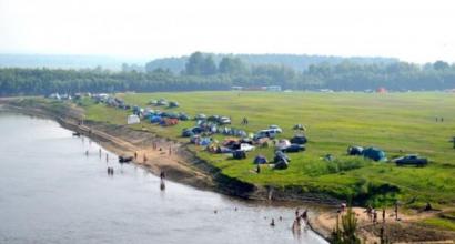
The Trans-Baikal Territory is famous for its marvelous nature and mineral springs, in terms of the number of which it ranks second after the Caucasus. snow covered Mountain peaks, centuries-old taiga, clear lakes and mountain rivers delight and enchant a person who first came to this land. The sky here is almost always clear and clear - by the number sunny days the administrative center of Chita is even equated with Sochi.
The Trans-Baikal Territory is a territory where different peoples have left their centuries-old traces in the form of architectural and archaeological monuments, interesting customs, beliefs and rituals. There are many monuments of the Buryat national culture. You should definitely visit the Alkhanai National Park - the only place in Russia where natural attractions harmoniously coexist with the sacred objects of Buddhism.
List, photos with names and descriptions of attractions worth visiting!
1. Daursky Reserve
It is located in the south of Transbaikalia, on the border with Mongolia and China. Founded in 1987 to protect the steppe ecosystems of Dauria. The main object is the Torey Lakes, the largest in the region, a nesting and resting place on the migration of many birds, including very rare ones, for example, the relict gull. Only 6 species of cranes live here. Also, the reserve is the only habitat of the gazelle antelope in the country. Another attraction is the granite remnants of unusual forms of Adun-Chelon.
2. Butinsky Palace
The main attraction of Nerchinsk. It was erected in 1860-1870. Belonged to well-known merchants in the city, gold miners and philanthropists Butin. It was famous for its unique Venetian mirrors and a magnificent garden with tropical plants. In the courtyard of the estate, in addition to a chic medieval-style palace, there were water towers, warehouses, park areas, gazebos, and fountains. In the early 2000s, the building was restored and transferred to the local history museum.

3. Great source (Mount Pallas)
A small mountain of the Yablonevoy ridge with a height of 1236 m. A monument of nature. Serves as the beginning of three largest rivers- Amur, Lena, Yenisei. It is at this point, called the Great Source, that the basins of two oceans, three seas and three rivers meet. This discovery was made in the second half of the last century. The area attracts tourists with fresh air, endless expanses of water, larch taiga, and high cliffs. In addition, the Great source is a place of religious pilgrimage.

4. Kodar National Park
Created in 2018 in the north of Transbaikalia. Area - 492 hectares. Mountain taiga forests along the banks of two rivers - Chara and Vitim, ecosystems of the Kodarsky mountain range, habitats of endangered animals, such as the bighorn sheep, historical and cultural objects are subject to protection. On the territory of the park there are the famous Chara Sands, volcanoes, glaciers, 570 lakes, mineral springs, Marble Gorge and others. natural objects. Tourist routes are being developed.

5. Chara Sands
Sandy desert with an area of 10 by 5 km in the middle of the taiga. It is located at the foot of the Kodar ridge, in the Chara basin. The dunes reach a height of 80 m, the length of the largest ones is up to 200 m. There are 2 lakes on the border of the sands. It is believed that the desert arose on the site of an ancient glacial lake, from which only small water fragments remained, scattered throughout the basin. Is in hard to reach place, although the nearest village of Chara is 9 km away.

6. Glaciers of Kodar
Monument of nature. The only place of mountain icing in Transbaikalia. It is located 50 km from the village of Chara. The main feature is a great distance from the sea and ocean coast. total area glacial massif - more than 6 thousand hectares. It was opened in 1958. About 40 glaciers have been discovered and studied, the largest have their own names. The surroundings are very picturesque and attract climbers not only from Russia, but also from other countries.

7. Alkhanay National Park
The main pearl of the park in the Aginsky Buryat district is the Alkhanai mountain range covered with forests. It is a monument of nature and at the same time one of the main Buddhist shrines. The objects of worship for pilgrims are stone figures and structures created by nature itself. Among them are the temple of the Great Good with healing water, the Temple of the Gate rock in the form of a 6-meter arch, the remnant of the Diamond Princess with a natural bowl, the cave "Mother's Womb" and others.

8. Assumption Church in Kalinino
The oldest building in Transbaikalia from the surviving buildings of the pre-revolutionary period. It was consecrated in 1712. It was built as the main temple of the male Assumption Monastery, which was subsequently simplified, and the church was turned into a parish. Built in the Moscow baroque style. In 1929 it was closed and ruined. Since 1970 it has been completely abandoned. There have been talks about restoration for a long time, but so far the building is more and more destroyed.

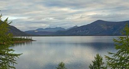
9. Lake Arey
Monument of nature. The area is 4 km 2, the maximum depth is 13.5 m. It is famous for its healing air - it is surrounded by larch and coniferous forests. They are complemented by picturesque glades of "alpine meadows". Mud from the bottom of the lake has medicinal properties and is used by local health resorts for the treatment of skin diseases. Areya water is saturated with oxygen, contains silver, iodine and other useful substances. There are many anthills on the coast. There are several sources.

10. Baikal-Amur Mainline
One of the largest railway lines in the world. Length - 4287 km. It starts in the city of Taishet, crosses 11 rivers, 7 mountain ranges, 60 settlements and ends on the Pacific coast. Construction began before World War II and continued in 1974. The first trains along the BAM route passed in 1984. 10 tunnels were built along the entire route, the most difficult one was made in the North Muya Range. Its length is more than 15 km.

11. Kazan Cathedral in Chita
The main Orthodox church in the city was consecrated and opened in 2004, on the occasion of the 110th anniversary of the founding of the Trans-Baikal diocese. Built on central square, on the site of the former cathedral, destroyed in 1936. Made in the style of traditional church architecture of the XIV-XVI centuries. A majestic look is given by 5 light drums with bulbous domes. Can accommodate more than 2 thousand believers. It has a 60-meter bell tower, on which there are 13 bells.

12. Aginsky datsan
Located in the village of Amithasha. Date of foundation - 1811. Originally consisted of one main and four small temples. Then another building was added, and by the end of the century the datsan became the largest in Transbaikalia. Buddhist monastery. He was famous for his library, medical, astrological and philosophical schools, he himself printed textbooks, dictionaries, ritual texts. In the 30s of the last century it was closed and plundered. In the early 1990s, it was re-consecrated.

13. Shumovsky Palace
The family nest of the gold miners of the Shumov brothers. The date of construction is 1914. The facade of the three-story mansion is painted in pink color, has white decorative columns, generously decorated with stucco in the form of floral ornaments, spirals, animal muzzles. The roof is crowned with domes with spiers. The interior decoration is no less luxurious - marble floors everywhere, wall paintings, molding, forged metal gratings on the stairs. Today the palace houses the department of the FSB.

14. Chita datsan
The very first Buddhist temple in Chita. It was built over 8 years, was consecrated and opened in 2010. To decorate it, a 2-meter gilded Buddha statue, brass lions mounted on the sides of the main deity, and a sacrificial censer were specially delivered from the Mongolian city of Ulan-Ude. Currently, services are held within the walls of the datsan - khurals, various rituals and ceremonies designed to help and protect from negative forces.

15. Heetei Caves
Monument of nature, consisting of two karst caves– Dry and Wet. The largest in Transbaikalia, the total length is 150-160 m. The wet cave is of the ice type, has 4 grottoes, the area of the largest is 70 by 60 m. To go down into it, you need to overcome a 12-meter icefall. The second cave - Dry or Summer - consists of a large funnel, at the bottom of which limestone blocks are located. It is advisable to visit the caves as part of excursions and with special equipment.

16. Chita Zoo
The first animals in the Pioneer Park of Chita appeared in 1986 through the efforts of the employees of the Palace of Pioneers. And the official opening date of the city zoo should be considered 1994. The number of its inhabitants is steadily growing. Today, 156 species of animals live here, about 700 individuals. Many have offspring, including exotic Alexandrian parrots, which rarely breed in captivity. Excursions are organized for visitors to the zoo.

17. Trans-Baikal Botanical Garden
The botanical garden in Chita covers an area of 2.8 hectares. It also includes a nursery with an area of 24 hectares in the village of Peschanka. Tropical, ornamental, woody, medicinal plants, collections of roses, irises, lilies, etc. are grown here. The assortment is constantly replenished through expeditions and the exchange of seeds with other botanical gardens. Educational excursions are conducted by the staff of the institution. Of particular interest is a visit to the greenhouse winter gardens.

18. Museum of the Decembrists
More than 70 Decembrists were in hard labor in the current city of Petrovsk-Zabaikalsky, from 1830 to 1839, the wives of 10 of them lived nearby. The museum was opened in 1980 in the surviving two-story mansion of Princess E. Trubetskoy. The expositions are located in 5 halls and acquaint visitors with the history of the Decembrist movement, as well as with the living conditions in which the exiled Decembrists lived. Among the exhibits are drawings, documents, books, household items.

19. Church of the Decembrists
The two-storied Archangel Michael Church is the most ancient building in Chita, a monument of wooden church architecture. Date of foundation - 1776. In the 70s of the last century, it was transferred to the local history museum, since 1985 a museum of the Decembrists has been opened on its territory. Many of them visited this temple while in exile, some got married here. The museum contains more than 800 original exhibits, including personal items, books, letters from the Decembrists and their wives.

20. Lake Arahley
Among the largest lakes in Russia. It has a length of 11 km, a maximum depth of 20 m. The shores are very picturesque, covered with larch taiga with fragments of forest-steppe. There are sandy and sandy-pebble beaches. It is famous throughout the region for its noble year-round fishing. The ichthyofauna is represented by 15 species of fish. It is believed that Arahlea fish is tastier and larger than the same in neighboring lakes. On the coast are the villages of Preobrazhenka, Tasey, recreation centers, camps.

21. Lake Shakshinskoe
It is located 40 km from Chita, on the territory of the Arakhleysky reserve. The second largest after Arahlea. Has an oval shape. Length - 11 km, maximum depth - 6.5 m. underwater world. Coastal flora - larch taiga forests with areas of forest-steppe and meadow zones. The water is fresh, in the middle of summer it warms up to +22˚С. There are all conditions for year-round fishing and a cozy holiday on the picturesque coast.

22. Chita Cathedral Mosque
The only example of a Muslim cult preserved in Transbaikalia. It was built at the beginning of the last century with donations from members of the city's Muslim community, which was very rich and numerous at that time. It is a two-storey red-brick building with a high octagonal minaret tower. Can accommodate up to 800 people. In 1935-1995. was closed. Today the mosque is functioning, a Tatar school has been opened with it.

23. Titovskaya Sopka
Located in the southwest of Chita. Named after the ethnographer and archaeologist E. Titov. Represents dormant volcano the Mesozoic era. Height above sea level - 1 km. It contains more than 30 archaeological sites - fragments of ancient settlements, petroglyphs, tools, animal remains were found. At the foot of the hill there is a monument to the organizers of the Chita Republic, who were shot in 1906. A chapel was also built here and a worship cross was installed.

24. Sukhotino Rocks
High granite cliffs with steep cliffs. Monument of nature and archeology. They are located in the suburbs of Chita, on the banks of the Ingoda River, surrounded by amazing nature - pines, birches, willow bushes, rosemary thickets. Lots of different insects. Archaeological finds in the vicinity are 25 thousand years old. Among them are the remains of ancient people, animals, various products, petroglyphs. The area is popular with fishermen and rock climbers.

25. ODORA Park
Located in the center of Chita. Leads its history from the end of the XIX century. Since 2010, it has been updated and improved. Children's zones, attractions are equipped, for the elderly - a retro playground. There are many sculptural compositions, among which are the scientist cat, Zhdun, the figure of the actor A. Mikhailov in the image of Vasily from the film Love and Doves. Military equipment is presented on the Walk of Fame. A "Treasure Island" was created - a recreation area with a pond, a bridge, gazebos, and a reconciliation bench.

26. Sokhondinsky Reserve
Located in southern Transbaikalia, in the vicinity mountain range Sohondo. Organized in 1973. The area is more than 200 thousand hectares. Great landscape diversity - steppe zones, deciduous and coniferous forests, mountain tundra. There are many mineral springs - arshans and mountain glacial lakes. The fauna includes 67 species of mammals, including 15 species of predators, 250 species of birds, 1200 species of arthropods. The world watershed passes through the protected area.

27. Chikoy National Park
Created in 2014 to preserve virgin natural complexes in the upper reaches of the Chikoy River. The area is more than 600 thousand hectares. A lot of Red Book animals and birds live here. There are several natural monuments, the most interesting is the Lamsky town. This is a collection of free-standing rocks of the most incredible form, created by master nature. The height of some of them is 50 m. Several tourist routes pass through the park.

28. Mineral spring Molokovka
Sources from mineral water in the valley of the Molokovka River, not far from Chita, have been known since the 19th century. That's when it was founded balneological resort, which is still working today, known far beyond the borders of the region. Basically, water from two sources is used for treatment - glandular and soda. In addition to them, in the Molokovka valley there are other sources with a pleasant taste of mineral water. There is a chapel next to the ferruginous spring.

29. Marble Gorge
Rocky treeless valley in the Kodar Mountains, surrounded by 200-meter cliffs. Its name is associated with the abundance different types marble. It attracts tourists with its dark history. In the middle of the 20th century, there was a uranium mine and a labor camp for political prisoners serving as the main labor force. Uranium reserves turned out to be small, the camp lasted 2 years. His buildings, barbed wire, household utensils have survived to this day.

30. Kondui settlement
It is located in the middle of the steppe, 7 km from the village of Kondui. Fragments of a 14th-century settlement are related to early history Mongolian state in the territory of Transbaikalia. Here, on an artificial embankment, the palace of the Mongolian feudal lord, who belonged to the imperial family, was built. Nearby was a garden with gazebos, pavilions, a swimming pool. And although today the territory of the settlement is neglected, only the ruins of the castle and gravestones in the ground remain - there are always a lot of tourists here.

The Trans-Baikal Territory is located in the eastern zone of Transbaikalia. It is part of the Historical and natural monuments The Trans-Baikal Territory is famous, sights in this place are at every step. The area of this territory is 2.52% of the area Russian Federation. Everything here captivates with its scale and uniqueness. The main sights of the Trans-Baikal Territory constantly attract tourists. At all times, people were amazed by the variety of relief, natural beauties and
Sights of the Trans-Baikal Territory
Photo describing these beautiful places can be found in the article. But it is best to visit Transbaikalia in person. This is the only way to feel the greatness of nature, the height of the mountain peaks and the expanses of the steppes. Tourists are recommended to visit such places:
- Sokhondinsky reserve;
- Lake Arey;
- national park "Alkhanay";
- ridge Kodar;
- Butinsky Palace;
- numerous museums.
Sokhondinsky Reserve
In this protected place, nature is striking in its diversity. It combines several ecological systems:
- taiga;
- steppe;
- swamps;
- mountain tundra.
The length of the reserve is 211 thousand hectares. It is located on the Khentei-Chikoy highlands with the Sokhondo mountain range. Sohondo loach is ancient volcano. Its slopes delight with whimsical forms.
This place is characterized by dry and little snowy winters. The climate is continental. There are a lot of lakes here glacial origin. Their depth is more than twenty meters. Plankton and algae do not take root in them, in this regard, they are famous for their transparency, the water there has a slight blue tint.
In the Sokhondinsky Reserve, such rivers as the Selenga, Amur, Angara, Yenisei take their source. It is noteworthy that they belong to the basins of different oceans. Cupid belongs to Pacific Ocean, and Selenga, Yenisei, Angara - to the Arctic.
The rarest plants that are listed in the Red Book grow in these parts, such as leafless chin, real slipper, large-flowered slipper, smooth iris, spotted slipper, Siberian apricot, dwarf and Pennsylvania lily, Altai onion, Ayan backache, a couple of species of Rhodiola.
Fascinating with its diversity and animal world. On this moment it was found that 255 species of various birds, 67 mammals, three species of amphibians, four species of reptiles, eight species of fish and 1200 species of arthropods live in it.

Lake Arey
This reservoir is a hydrological monument of nature. If we talk about the Trans-Baikal Territory, the photo of the sights of which is in this article, first of all it is worth mentioning this wonderful lake. His fame is due to a combination of a number of factors:
- the lake is striking in the variety and quantity of fish, which is undoubtedly a huge plus for avid fishermen;
- the waters of Arey contain a lot of oxygen, but are poorly mineralized;
- mud at the bottom has healing qualities, eliminates numerous skin diseases;
- on south coast there are huge anthills built by northern ants, some of the structures reach a diameter of 2-3 meters;
- at the very bottom of the Arey, a unique Arey potato grows, it cures diseases of the gastrointestinal tract.

Alkhanay National Park
"Alkhanai" is located on the territory of the Duldurginsky district. It is famous for its natural beauties. The whole nature of this place is saturated with legends and beliefs. From ancient times, the tribes of the Buryat-Mongols brought up love for this land in their descendants. They called for the unity of man with the outside world. In 1991, the head of the Buddhist clergy, the Dalai Lama, consecrated this land with his presence.
Day by day, interest in the national park "Alkhanay" is increasing. A huge number of believers come here to bow to sacred places and bathe in healing springs.
But not only natural monuments can be proud of the Trans-Baikal Territory. Historical sights are also striking in their uniqueness.

Trans-Baikal Alps - Kodar
This amazing place located in the north of Transbaikalia. First of all, the Kodar ridge attracts tourists here. This highest point Transbaikalia, a peak whose height is 3073 meters. The Kodar Ridge clearly stands out among the plateaus and midlands of Transbaikalia. Kodar is the "Transbaikal Alps". A traveler of any level can choose a route here that suits the difficulty.

Butinsky Palace
This palace belonged to the noble Butin family, who built unique and inimitable buildings for various purposes in the city of Nerchinsk. If you study the sights of the Trans-Baikal Territory, it becomes clear that the Butin Palace is undoubtedly the pride of the city of Nerchinsk.
The unique object of the palace is the Venetian mirror. They say that there is no such huge one in the world. Its dimensions are 4 meters long and 4 meters wide. To put it inside, they even dismantled the roof. The palace is also famous for its garden. Here you can find exotic plants that do not grow in the climate of these places.

Museum of the History of the SIBVO Troops
This landmark of the Trans-Baikal Territory was opened on the twentieth anniversary of victory in the Great Patriotic War. At the main doors there is an iron plate, on which the names of 1255 Siberian soldiers, Heroes Soviet Union. Three central halls are dedicated to the historical feat of the Russian people in the Great Patriotic War.
Everyone who goes to the Trans-Baikal Territory must visit these sights. We must pay tribute to the heroic feat of our ancestors.
This is only a part of the places that the Trans-Baikal Territory is famous for. Its sights can still be listed and listed. But it is better to go to this beautiful region and personally visit each of them.
Fabulous, unrealistic, whimsical, striking in their beauty - each of them is like a work of art, embodied in reality.
Great - nearby. The journalist of the newspaper "Zabaykalsky Rabochiy" brings to your attention a selection of the most beautiful places in Transbaikalia, which are worth visiting.
At any time of the year, the forests of Transbaikalia are a work of art of Nature. In our region there are both pine forests and mixed forests, where you can find larch, aspen, birch and shrubs, and at the end of March - snowdrops that cover our fields with a blue carpet. However, our forest becomes truly beautiful in late April - early May, when the Daurian rhododendron, or wild rosemary, as the inhabitants of the region affectionately call the shrub, blooms everywhere like a pink fire. It is listed in the Red Book and is rightfully considered one of the wonders of Transbaikalia.
It is worth special attention. Each lake has a unique, in its own way special beauty and charm, so we recommend visiting each of them.
Arahley - the most big lake Ivano-Arakhlei system of lakes, characterized by the greatest depth - in some places it reaches 20 meters. The bottom and the beach of the lake are sandy, and in summer there is a real full house on the banks of Arakhlei. In the lake you can meet perches, pikes and chebak, which makes the lake a favorite place for fishermen. And in general, having been there at least once, I want to return there again and again. What about sunsets...
Lake Shakshinskoe, or Shaksha

The second largest lake in the Ivano-Arakhlei system after Arakhlei with sandy shores and well-heated water. Roach, perch, dace, pike, crucian carp, peled, bream, carp and catfish live in the waters of Shaksha. Thanks to the abundance of fish and warm water in summer, the lake welcomes guests all year round, allowing us to admire its unique beauty.

Another lake of this system. Of all the names of the lakes of the Trans-Baikal Territory, the most remarkable is the origin of the lake with the completely Russian name Ivan. According to legend, in order to deceive the evil spirits that take children's lives, parents tried to choose unusual and unusual names for them for the Buryats. And so, near one of the lakes lived the Buryats Munko Udoev, whose children often died. Trying to save offspring, the father named his next son Ivan. Tradition says that just at that time a disgraced priest named Ivan was wandering around the lake. Munko's son grew up and proved to be more fortunate than his father, raising ten sons. The children grew up and began to live around the lake, which people called Ivan-Nuur, that is, Ivan-lake.

On the territory of the Trans-Baikal Territory there is a unique national park, which is a monument cultural heritage and home to endemic plant and animal species. On the territory of this park you can meet more than 120 species of various animals, some of which are listed in the Red Book - such as the black stork, bustard and golden eagle. The complex includes more than 20 cultural objects, among which the most famous and revered are Maanin Shuluun (a stone stele with a carved Tibetan mantra text), Dimchig Sume (Temple of God Dimchig - the owner of the mountain), Nara Khazhad (Heavenly Musician), Uuden Sume (Temple Gate) , Dorje Pagmyn Sume (Temple of the Diamond Queen - the wife of the owner of the mountain), "The Gap of Sinners", Ehyn Umai (Mother's Womb), Zurkhen Shuluun ( Stone Heart), Choreo Shuluun (Stone Fence) and many others. One of the most important natural and religious objects is the peak of Alkhanai. Walking route around the park takes about 5 days. Waters from springs - arshans are considered holy and are used for medicinal purposes, there are also clinics in the park.

, surrounded by pine forests, located at an altitude of 966 meters above sea level, characterized by magnificent scenery. The waters of the lake have healing properties - potassium was found in their composition, silicic acid, bromine, fluorine, lithium and other active elements were identified. The work carried out by Chita physicians showed that the waters and mud of Arey have an excellent therapeutic effect and are indicated for the treatment of dermatitis and trophic ulcers. Currently mud is used by the Molokovka sanatorium.
5. Karpov rapids, upper reaches of the river. Karpovka

Stunning stone rapids and foaming ice water resembling milk - you can see this miracle with your own eyes after visiting the Karpov rapids. The waters of the Karpovka River have a constant temperature of -2 degrees Celsius and do not warm up even in summer.

One of the numerous rivers of Transbaikalia, cutting through the Chersky Range, with a rapid current and cold water, in which you can meet grayling galloping on the rapids. In the upper reaches of Nikishikha there is a zoological reserve, and where the river passes through the ridge, a climbing wall was recently built, where you can go with your family and, under the guidance of experienced instructors, conquer the rocks of the ridge.

archaeological site Trans-Baikal Territory of the Early Paleozoic. Local historians say that this place owes its name to an unfortunate officer named Sukhotin, who was brought to the top of the formidable rocks by alcohol and unhappy love. He rushed down and crashed against the stones that Ingoda grinds day and night, and a group of rocks and a patch of forest around were called Sukhotino. In order to visit there, it is enough to take a minibus to the Klyuchi plant and climb the slope along the river. All beauty is at the edge. Rocks pile up over Ingoda to a height of 100 meters, and sitting on top you can watch the slow and measured flow of the river, hear its quiet distant splash, enjoy the view of the hills and breathe the cleanest air.

The widest, full-flowing river flowing in the Chita region. It is a pleasure to observe her changeable character - in some places she demonstrates a stormy temper, quickly running down the rifts, and somewhere she slowly and calmly carries her waters with a mirror smooth surface so that the current is almost imperceptible. Ingoda is beautiful at any time of the year, the photo is captured in winter calm sleeping under a thick cover of an ice blanket.
ZABAIKALSKY TERRITORY: FACTS AND FIGURES
The Trans-Baikal Territory is a subject of the Russian Federation located in the eastern Transbaikalia and is part of the Siberian Federal District. It borders on the Amur and Irkutsk regions, the republics of Buryatia and Yakutia, has an external border with China and Mongolia. The territory of the region is 431.892 km, which is 2.53% of the area of Russia (12th place in this indicator in the Russian Federation). The population is 1,106,600 people. The Trans-Baikal Territory was formed on March 1, 2008 as a result of the merger of the Chita Region and the Aginsky Buryat Autonomous Okrug. The administrative center is the city of Chita. Most populated cities- Chita, Krasnokamensk and Borzya.
Climate

The region is characterized by a peculiar climate - sharply continental. The winter is long, dry and severe, comparable to the Yakut one: the weather is frosty, slightly cloudy, windless. Summer is short and warm (sometimes even hot), however, in the mountainous and northern regions it is cool. Storms and snowstorms are possible in spring, and the main precipitation falls from April to October. There are significant fluctuations in daily and annual temperatures, in some areas the spread is 90 degrees or more ( average temperature January: -28.3 degrees; July: +19 degrees) degrees. The frost-free period is 80-140 days. We add that a characteristic feature of the climate is a significant number of sunny days per year, comparable to the south of Russia.
Economy

The Trans-Baikal Territory is very rich in various mineral resources and has relatively favorable conditions for agricultural activities. A serious economic advantage is provided by direct transport access to the markets of the Asia-Pacific region. However, the progressive development of the region is hampered by severe natural and climatic conditions, increased natural radiation background, high seismicity, and rugged relief. For the economy of the region, the implementation of the project to create transport infrastructure for the development of rich mineral resources of the south-east of the region.
Industry
Main industries: mining (extraction of molybdenum, tin, lead-zinc and uranium ores, gold, coal), wood processing, ferrous and non-ferrous metallurgy, electric power industry.
Agriculture
The Trans-Baikal Territory is a large agricultural region specializing in fine-wool sheep breeding. Meat and meat and dairy production, poultry farming, and pig breeding are actively developing. Climatic conditions central, southern and southeastern regions allow the successful practice of crop production.
tourist attraction

The Trans-Baikal Territory has a rich variety of flora and fauna; this is a godsend for tourists who prefer pristine nature and environmentally friendly recreation. The most fastidious will find rest to their liking: the region has mountains, and the northern desert, and taiga forest, and steppes, and full-flowing rivers. Lots of food for thought for history buffs. ancient cities. But first things first.
Mountains
The region is dominated by medium-altitude mountains (700-1000 meters). There are also peaks - the Kodar ranges in the north reach 2,999 meters, and in the south, Mount Barun-Shabarshui rises to 2,519 meters.
Forest
The natural diversity is amazing. This is taiga, forest, forest-steppe and even tundra.
reservoirs

The Trans-Baikal Territory has a unique natural attraction: the Great Istok is located here, the place where the fresh waters of the entire planet are divided! streams fresh water go to the Yenisei, Lena, Amur, the Pacific and Arctic oceans and, of course, to the pearl of the Earth - Lake Baikal. The Baikal basin includes the right tributaries of the Selenga River - the Khilok and Chikoi rivers. And the Shilka and Argun rivers merge into the powerful Amur. Of the most significant water arteries, the Olekma and Vitim rivers (its tributaries are the Karenga, Kalakan, Kalar) can be noted. With every right, the Transbaikalians are proud of the whole collection of lakes. Big Leprindo, Leprindokan, Nichatka, for example - children of the Ice Age. Popular holiday destinations are the unique saline lake Nozhiy, Ivano-Arakhlei lakes, Arey. In the regional capital, right in the city, there is Lake Kenon.
Mineral springs and mineralized lakes
The fact that Transbaikalia is rich in healing waters was known even in Tsarist Russia. Mineral springs vary in composition: from thermal nitrogen to cold carbon dioxide, low and medium mineralization. Many of them have health resorts - the resorts of Yamarovka, Shivanda, Darasun, Molokovka, Kuka, Yamkun, Aksha and many others.
reserved places

The region is rich in natural monuments, relict dwarf oaks, cedar giants grow here, there are unique ecosystems (for example, the Chara Sands - a real desert in the middle of the taiga). To preserve nature in its original form, nature reserves and parks have been created: Daursky, Sokhondinsky, Alkhanai National Park, 20 reserves. Coming soon natural Park"Arey", work is underway on the construction of the Chikoy National and Kodarsky parks.
Buddhist shrines

It is believed that Transbaikalia is a place prayed by Buddhists. Most of shrines is located on the territory of the Aginsky Buryat district: sacred mountains, obo (Alkhanai, Adon-Chelon, Bolshebatosr). There are datsans (Aginsky, Tsugolsky, Ivolginsky and many others). The Buryats carefully preserve centuries-old traditions and customs. For tourists interested in the ancient religion, this is a real Mecca. It will also be interesting to the uninitiated.
History cities
As you know, Transbaikalia is an exiled region. The Decembrists left their bright mark, significantly influencing the course of the history of the region. The memory of them is carefully kept by Chita, Nerchinsk, Sretensk, Petrovsk-Zabaikalsky and other cities. Preserved houses, furnishings, records, photographs. The region has a long history of the Cossacks.
Summarizing, we note that tourists have a large selection of destinations: ecological (mountain, hiking, cycling and water sports tourism), cultural, educational, health-improving, religious, hunting and fishing.
Geography
Located in Eastern Transbaikalia. It borders on the Buryat and Yakut Republics, the Irkutsk and Amur regions, Mongolia and China. About a thousand kilometers from north to south and 800-1500 kilometers from west to east extends the Trans-Baikal Territory.
The main rivers are the Baikal, Lena and Amur basins.
Climate
Despite the internal diversity, in general, the climate of Transbaikalia is sharply continental - severe, with severe long winters and short but warm summers, and this despite the fact that this region is located at the latitudes of Belarus and Ukraine.
The severity of the climate here is due to the fact that Transbaikalia is located in the center of the vast Asian continent at a great distance from the oceans and seas, on the one hand, and, on the other hand, due to a significant elevation above sea level and the predominance of a dissected mountain-hollow relief.
Average January temperature: -28.3°С.
Average July temperature: +18.8°С.
Administrative-territorial structure
The Trans-Baikal Territory includes the Aginsky Buryat District, 31 districts (Aginsky, Akshinsky, Aleksandrovo-Zavodsky, Baleisky, Borzinsky, Gazimuro-Zavodsky, Duldurginsky, Zabaikalsky, Kalarsky, Kalgansky, Karymsky, Krasnokamensky, Krasnochikoysky, Kyrinsky, Mogoytuysky, Mogochinsky, Nerchinsky, Nerchinsko-Zavodsky, Olovyanninsky, Ononsky, Petrovsk-Zabaikalsky, Priargunsky, Sretensky, Tungiro-Olekminsky, Tungokochensky, Uletovsky, Khiloksky, Chernyshevsky, Chitinsky, Shelopuginsky, Shilkinsky), 10 cities (Chita, Krasnokamensk, Borzya, Petrovsk-Zabaikalsky, Nerchinsk, Shilka, Balei, Mogocha, Khilok, Sretensk) and 45 villages.
Population
National composition: Russians 89.80%, Buryats 6.10%, Ukrainians 1.03%, Tatars 0.71%, Armenians 0.31%, Belarusians 0.26%, other 0.23%. The number of men is 558 thousand people, the number of women is 596 thousand people. Urbanization 63.9%
Flora and fauna
Unique flora and fauna of Zabaikalsky national park, on the territory of which there is the largest seal rookery on Baikal and noisy bird markets, invariably arouse interest among scientists, the park is especially popular. On the territory of the park, you can meet such rare species of birds listed in the Red Book as whooper swan, black crane and black stork, peregrine falcon and white-tailed eagle.
Economy
Non-ferrous and ferrous metallurgy, mechanical engineering (car assembly plant, mining equipment plant), electric power industry (Chita and Kharanorskaya state district power stations), coal, light industry (worsted and cloth plant) are developed in the region.
The region is a large agricultural region to the east of Lake Baikal, specialized in fine-wool sheep breeding. Meat-and-dairy and beef animal husbandry, partly pig breeding, and poultry farming are also developed. Plant growing takes place, the main sown areas are concentrated in the central, southern and southeastern regions. Hunting is developed in the mountain taiga and northern regions.
Transbaikalia is significantly removed from the western part of the country, at the same time it is close to the Russian Far East and occupies a key position on the way to the Pacific Ocean and countries South-East Asia. Distance by railway from Chita to Moscow - 6074 km, Yekaterinburg - 4386, Novosibirsk - 2861, Khabarovsk - 3327, Irkutsk - 1013 km.
Minerals
Non-ferrous and precious metals, iron ore, coal, fluorspar, various building materials. The most famous deposits are: polymetallic ores - Novoshirokinskoye; copper ores - Udokan; titanium-magnetite ores - Kruchininskoye; coal - Kharanorskoye.