One of the most inaccessible islands in the world. The eight most remote islands in the world
The Tristan da Cunha and Pitcairn archipelagos and Easter Island are the most remote islands from land. Surprisingly, all of them are inhabited, tourists even come somewhere, despite the difficulties of the road and flight.
Tristan da Cunha
The Tristan da Cunha archipelago (the only island of the same name with the archipelago is inhabited). Located in the southern part of the Atlantic Ocean. Territorially belongs to Great Britain. From the continents, it is approximately equally allocated for more than two thousand kilometers, and the nearest settlement on the island of St. Helena is located 2160 kilometers away. There are no airports here, you can get here on scientific and fishing boats from South Africa (they go once a month).
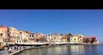
The only settlement is Edinburgh of the Seven Seas (sometimes called simply "The Village"), where 264 people live (descendants of American, English and Dutch immigrants). It has everything you need for life: a school, a hospital, a police station, a post office, a supermarket, two churches (Catholic and Anglican). Local residents are engaged in agriculture, fishing and working in the public service.
Tristan da Cunha on the map

Easter Island
Easter Island Located in the southern part Pacific Ocean 3514 kilometers to the continental coast and 2075 kilometers to Pitcairn Island, the nearest locality. Territory of Chile. You must have heard a lot about the island thanks to the stone giant moai, which can be found on the coast, near volcanoes or settlements. It is still unknown why they were created and how they were transported throughout the island. There is a hypothesis that Easter Island is a fragment of a disappeared continent. One way or another, but this is one of the most mysterious places on our planet.
There are no trees here(presumably they were cut down in the IX-XVII centuries), but there is an airport that daily brings curious tourists from all over the world. Locals fish and serve tourists, this is their main income.
Easter Island on the map

Pitcairn Islands
The Pitcairn Islands (only one of them is inhabited) is a British Overseas Territory. The nearest settlement is 2100 kilometers away. This is the most sparsely populated area in the world. Up to 48 people live here permanently. Basically, these are the descendants of the rebels from the British ship Bounty. Curiously, in the middle of the last century, 300 people lived here, but most of them emigrated to New Zealand.
One way or another, each of the residents is busy with business, torn between public service(there is a post office, a police station, a grocery store and a bar, everything is as it should be) between the household. Curiously, citizens of the Russian Federation do not need a visa to Pitcairn (so far only two of our compatriots have been here), subject to a number of conditions.
Pitcairn on the map
Tristan da Cunha is the most remote inhabited island in the world. To the nearest land - the island of St. Helena - more than 2 thousand kilometers, to the nearest coast of the African continent - more than 2700 kilometers. 272 people live permanently on the island. The only island of the archipelago with a permanent population.
Tristan da Cunha is an archipelago in the South Atlantic Ocean, which is part of the British overseas territory Saint Helena. Along with Easter Island, it is one of the most remote inhabited places on Earth. Located 2816 km from South Africa, 3360 km from South America and 2161 km south of Saint Helena.


Tristan da Cunha is a group of small volcanic islands in the South Atlantic Ocean in the British dependency of St. Helena. The islands are located within 37°6' South latitude and 12°1' West longitude. total area islands - approximately 202 sq. km. On Tristan da Cunha, the largest (98 sq. km) and the only inhabited island of the entire group (population in 1988 - 313 people), at an altitude of 2060 m there is a volcano that was silent until 1961, when it happened his eruption. Most of the inhabitants of the island are descendants of British soldiers who were stationed on Tristan da Cunha during the time of Napoleon's imprisonment on St. Helena, some residents are descendants of whaling sailors who once settled on the islands. The inhabitants of the islands are engaged in agriculture, fishing and animal husbandry. Since 1942, the British radio and weather stations have been located on the island. Until 1948, there was no organized form of government on the islands. In 1950, the first Governor of St. Helena was appointed, and in 1952 a general election was held for the Island Council. Other islands in this group: Gough, Inaccessible (Inaccessible) and Nightingale (Nightingale). The islands were discovered in 1506 by Portuguese sailors under Admiral Tristro Cunha and were annexed by Great Britain in 1816. During the volcanic eruption in 1961, all the inhabitants of the islands were evacuated, but later, in 1963, they returned to their native places.


Tristan Da Canha is home to a population of 270 very isolated people, with an economy based in the fishing industry. The climate of the islands is temperate oceanic, rainy and windy. On Gough Island, the average monthly temperature ranges from +9°C to 14.5°C, on northern islands- from +11 °С to 17.5 °C. Precipitation per year varies from 2000 mm in the north to 2500 mm on Gough Island.

The islanders often find themselves hostages of Atlantic storms: wind gusts of almost 190 km per hour were once so strong that they lifted cows and sheep into the air, and they fell into the ocean and died there ...

Tristan da Cunha is the only island in the archipelago with a permanent population. The main settlement of the island is Edinburgh of the Seven Seas in the northwestern part of the island. Other settlements are unstable and are scientific bases and meteorological stations. The population of the island is about 300 people. Tristan da Cunha is an island of volcanic origin that appeared about a million years ago. On the island is located highest point archipelago - the peak of Queen Mary (Queen Mary), a height of 2055 meters above sea level. In winter, the top of the mountain is covered with snow. Queen Mary is a volcano that has erupted several times since the discovery of the island. Tristan da Cunha has a rocky coast and mountainous terrain, numerous ravines, which the locals call "gorges" ("gulches"). The only territory of the island adapted for permanent human life is the northern and northwestern part. You can land there from the sea without much risk.

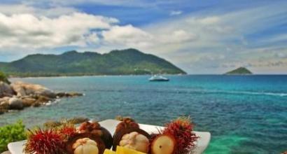
And this is the "breakfast" of the inhabitants of this island - Authentic Tails of Tristan Lobster - they say it is very tasty!

The island now has a mini market, radio station, cafe, video store and swimming pool. Tristan is connected to the world by one telephone and fax in the Manager's Department, and is visited once a year by the only mail ship in the world. This ship brings not only mail, but also canned food, videos, books and magazines, medicines.


In the South Atlantic, the uninhabited and cold island of Bouvet was lost. This small piece of land is the farthest from any nearest permanent settlement on the planet. It is sometimes referred to as "the loneliest place on Earth".

general description
Bouvet Island is an ellipse stretching from east to west. Its dimensions are approximately 9.5 by 6.5 kilometers. The surface area is about 49 km2. About 93% of the entire island is occupied by glaciers. The nearest permanent settlement called Edinburgh of the Seven Seas, with a population of about 300 people, is located in the northern part of the island of Tristan da Cunha, 2270 kilometers north of Bouvet.
Bouvet Island is of volcanic origin, the center is the crater of an inactive volcano filled with ice. According to scientists, the last eruption here was about 2000 years ago.
On the this moment Bouvet is a dependent territory of Norway, which means that formally the island is not part of the state, but is considered under its protectorate. A striking example of a dependent territory is Greenland.

Climate, flora and fauna of Bouvet Island
Bouvet Island is dominated by a maritime Antarctic climate characterized by strong clouds and fogs. The average annual air temperature is about -1 o C. Moreover, annual fluctuations are minimal, from -5 o to +4 o.
The maximum temperature of +14 ° C was registered in March 1980.
The harsh climate and landscape are not conducive to the spread of wild vegetation. Here you can find only mosses and lichens growing on ice-free land areas.
The animal world is more diverse. More than 10 species of sea birds nest here. At the end of the last century, there were over 100,000 penguins of several species. The island is also used by fur seals and seals during the breeding season. Giant humpback whales and killer whales are found in the surrounding waters.
Since 1971 Bouvet Island has been a nature reserve.

History of several discoveries
The island has been discovered several times and has always been called differently.
It was first discovered by Jean-Baptiste Charles Bouvet-De-Lozier, a French navigator. He was looking for the unknown Southern Continent and on January 1, 1739, he saw land. Then the captain failed to land on it and find out if it is an island or part of a new continent. In addition, Jean-Baptiste incorrectly determined the coordinates of this piece of land, which misled his colleagues in the captain's case. So in 1772 the legendary James Cook did not find the island using French coordinates.
The rediscovery took place in 1808 by Briton James Lindsay. He was the first to prove that it was an island and calculated its exact coordinates. But then it was not considered the land originally discovered by the Frenchman, and they began to call it “Lindsay Island”.

Benjamin Morrell, Capt. American ship, claimed to be the first to land on the island in 1822. But there are doubts, since Morris never mentioned that the island is almost completely covered in ice. The first landing on Bouvet in December 1825 was officially credited to British Captain Norris. He had already given the island the name "Liverpool" and proclaimed the possession of Britain.
In those days, any "ownerless" territories were declared their possessions. This happened with the island of Amsterdam in the Indian Ocean.
In 1927, the First Norwegian Expedition, led by Harald Horntved and financed by Lars Christensen, was the first to succeed long stay on the island. A small hut was even built here. On December 1, the Norwegian flag was already flying over the island.

Norway has made a claim to the right to own it. Great Britain protested it, but, due to the inaccessibility and low importance of the object, in 1929 it renounced the rights to the island. Thus, Bouvet became a dependent island of Norway and retained its original name.
It is noteworthy that the dispute was quite peaceful and civilized. But the "cruel" war for the island of Hans between Canada and Greenland is still ongoing. The viscous (yes, yes, we were not mistaken, namely the viscous) battles continue. Read and understand what is at stake. Read about Hans Island and the Whiskey War.
Bouvet Island now
To this day, the island is uninhabited. For tourists, it is hardly of interest, but for scientists it is definitely important. An automatic weather station is located here, which is subject to annual maintenance. Landing on Bouvet is very difficult: on the one hand, glaciers, and on the other, sheer cliffs, almost 500 meters high. The best way to get here is by helicopter.


Surely many of you have ever thought of leaving everything and leaving to live in some outlying area. But seriously, could you live on top of a mountain, at the bottom grand canyon or on an island so small that planes can't even land there? Meanwhile, people live in these and even more incredible places.
Tristan da Cunha is the most inhabited island on the planet from the nearest landmass. Their closest neighbors are located almost 2,000 kilometers away - in South Africa, and to South America it is about 3,000 kilometers away. Nevertheless, according to the latest data, 297 people live here, and they are all descendants of 15 people - 8 men and 7 women - who arrived on the island between 1816 and 1908. There are only 8 surnames and about 80 families on the island.
Tristan da Cunha, due to its isolation, has its own English dialect. They have their own Island Council of 11 members. The islands can only be reached by water - fishing boats from South Africa stay here 8 or 9 times a year. In 2000, television finally appeared on the island with the help of the BBC.
You might run out of breath on your way to La Rinconada - the world's highest settlement is located in the Peruvian Andes at over 5,000 meters.
Moreover, La Rinconada is located not even on the top of a mountain, but on top of a frozen glacier. This mountain dwelling can only be reached by truck, and about 30,000 people live here. 
Greenland, with a population of 57,000, is already a very remote place in itself.
But Ittoqqortoormiut is still the most remote part of it. This small fishing and hunting village is located on east coast islands just north of Iceland. About 500 people live in Ittoqqortoormiut, and you can get here by boat for only three months a year because of the glaciers. The airport is about 40 kilometers away and is used very rarely. 
The Kerguelen Archipelago is also known as the "Abandoned Islands".
It is located in the south of the Indian Ocean, and the only way to get to it is to spend 6 days on a boat from Reunion Island near Madagascar. Scientists and engineers come to the archipelago and live here for a whole year because of its proximity to Antarctica. 
Consisting of a bunch of tiny islands, the Pitcairn archipelago is located in the very center of the South Pacific Ocean.
The closest of the neighboring islands are hundreds of kilometers away. About 50 people live here, and most of them are descended from members of the crew of His Majesty's Ship Bounty, which ended its rich history on Pitcairn. 
Alert, a remote village in the Canadian province of Nunavut, is located just 750 kilometers south of the North Pole.
Only 5 people live here all year round, probably due to very low temperatures. In summer, the sun shines here 24 hours a day, and in winter, on the contrary, it is dark all the time. The nearest corner of civilization - fishing village approximately d 1,800 kilometers. There is an airport in Alert that is used by the military, but due to the ultra-cold climate, this is extremely rare. 
Medog County in the Tibet Autonomous Prefecture of China is so small and remote that no road leads to it.
You have to make your way to it through the Himalayas, and enter it with the help of suspension bridge at an altitude of more than 200 meters. However, the trip is clearly worth it. Medog is known for the untouched beauty of its nature. Millions were spent to build a road here, but all attempts were in vain due to avalanches, landslides and other natural disasters. One of the constructed highways worked for only a few days, until it was washed away into the forest. 
Macquarie Island lies roughly halfway between Tasmania and Antarctica and is therefore ideal for Australian scientists.
The 20 researchers who live here with their equipment make up the entire population of the island. 
One of the most remote inhabited places, oddly enough, is in the United States.
Supai, Arizona has only 500 people. The peculiarity of the town is that it is located at the bottom of the Grand Canyon. It is so difficult to get here that the mail is delivered by mule. Supai is really easy to miss - during the 2000 census, the town was simply missed. 
The inhabitants of the Republic of Nauru are the smallest island people in the world, with a population of 10,000 people.
Known as the "pleasant island", Nauru nevertheless has almost no tourism industry. To get here, you first need to fly to Brisbane, Australia, and only then take tickets for a flight to Nauru, which flies once a week. 
> 10 most inaccessible places on Earth
There are no more white spots on our planet, but, nevertheless, there are many secluded corners that are inaccessible to most tourists ...
10. Easter Island, Chile


Easter Island, or Rapanui, belongs to Chile and is considered the most remote island on the planet from the continent (3500 km to the coast of Chile).
On April 5, 1722, the Dutch traveler Jacob Roggeveen noticed the island of Rapanui on the horizon and named it in honor of the great Easter holiday. At the time of the discovery of the island by the Dutch admiral, the population of the island was 2-3 thousand people. After this event, the island was forgotten for 50 years. And in 1770 the island was annexed by Spain.
The ancient culture of Easter Island is shrouded in mystery and charm. The most famous symbol of Easter Island is the large statues-idols made of stone. Moai statues reach a height of 20 meters. They are made in the form of a head with a torso.
Moai idols were made in the period from the 12th to the 15th centuries, after this period their production abruptly stopped. Why the production of Moai stopped and where the people who inhabited the island disappeared is still a mystery.
9. City of La Rinconada, Peru


The city of La Rinconada is located in the Andes mountains in the permafrost zone at an altitude of 5100 meters above sea level. Getting to the city is very difficult. The air temperature here is always below zero. There are no plants suitable for human consumption. And because of rarefied air, people quickly lose strength.
La Rinconada was formed at the end of the 20th century as a small settlement of gold miners. From the side of the plain opens a magnificent landscape mountain peaks, but when you drive closer, the smell of rotting industrial waste hits your nose.
The population of the city is 30 thousand people, almost all of them are engaged in gold mining in mine caves. La Rinconada has a dubious reputation as a city for the poor and the desperate. Gold mining is carried out in terrible conditions, people are not paid wages, they work for a percentage of the gold found, but not everyone and not always find it.
Life expectancy in the city is about 50 years. There are reasons for this: there are many accidents, people live and work in poor conditions, the ore emits mercury vapor.
8. McMurdo, Antarctica


Antarctica is located at the bottom of the world, and is one of the most remote places on the planet. This is the only mainland without indigenous people. Here, on the southern tip of Ross Island, is the largest American research station, the largest human settlement, the port and the named capital of Antarctica - McMurdo. Date of foundation: February 16, 1956 Distance between McMurdo and New Zealand is 3864 km.
1258 people live and work here in more than 100 buildings. It used to take several months to get to McMurdo, but now the airstrips allow you to get to the place much faster. The station has many modern amenities - gyms, and even a golf course.
7. Cape York Peninsula, Australia


Australia is known for its low population density and unspoiled natural beauty. Cape York Peninsula is located on the northern tip of the mainland, due to the inaccessibility of the area, there are huge expanses of virgin nature.
The population of the peninsula is about 18 thousand people, most of which are made up of indigenous people. Cuyp York is considered the largest site in the world that has remained largely untouched by civilization. The area of the peninsula is 137 thousand km2, the length from north to south is 600 km.
6. Ittoqqortoormiit, Greenland


The area of Greenland - the largest island in the world - is 2,130,800 km2, and the population is 57 thousand people, which makes Greenland also the most deserted inhabited island in the world.
by the most hard to reach place in all of Grendandia is the town of Ittoqqortoormiit. You can get to it by plane (only 2 times a week), by helicopter or by boat - several months a year. The population of the town of Ittoqqortoormiut is 452 people. Residents make a living by hunting polar bears, whales and halibut.
Ittoqqortoormiut was founded in 1925 by Einar Mikkelsen and 70 other settlers from the ship Gustav Holm.
5. Kerguelen Archipelago, Indian Ocean


The Kerguelen archipelago belongs to France. The islands are located in the Indian Ocean. The distance from the archipelago to Antarctica is 2000 km, to Australia - 4800 km.
The Kerguelen Islands are known as the "Islands of Desolation" and have no permanent inhabitants. In winter, about 100 people are employed in the fishing industry.
The archipelago was discovered by a French expedition in 1772. The group of islands was named after the leader of the expedition, whose name was Yves Josève de Kerguelen.
4. Pitcairn Islands, Pacific Ocean


The Pitcairn Islands are the only British possessions in the Pacific Ocean. The islands are located in the South Pacific Ocean, bordering Polynesia.
One island out of 5 is inhabited. Pitcairn is the most sparsely populated area on the planet. Pitcairn has a population of 49, many of whom are descendants of famous ship"Bounty".
In 1787, the three-masted merchant ship Bounty set sail for Tahiti to buy breadfruit seeds for the Jamaican plantations. In 1789, there was a riot on a ship in Tahiti. Fletcher Christian seized power and ousted the ship's captain, William Bligh. Fearing a punitive expedition, he, with other apostates and several local residents went to uninhabited islands. They landed on Pitcairn Island, burned the ship and founded a colony.
Today, the descendants of those sailors live off Agriculture, fishing, and selling very rare postage stamps to collectors. But even if there is modern transport, it is still one of the most isolated communities in the world. There is no airstrip on the island, and to get there from the mainland, you need to sail by ship for about ten days.
3. Alert, Canada


The unique village of Alert is located in Canada - it is the northernmost settlement in the world. There are several meteorological and research stations on the territory of the village. The population is about 10 people. In addition to the indigenous people, 5 meteorologists and about 70 military men live here. Year of foundation - 1950. The nearest settlement from the village of Alert - 3578 km.
The climatic conditions here are quite severe, in winter up to minus 34 degrees Celsius. The temperature is above zero here only in July and August. Alert is attractive for extreme lovers and naturalists. Alert is very beautiful in summer.
2. Tristan da Cunha Island, Atlantic Ocean


The world's most remote inhabited island, Tristan da Cunha, is located in Atlantic Ocean at a distance of 3200 km from the coast of South America and 2700 km from the coast of South Africa. Tristan Island is the largest and only inhabited island the Tristan da Cunha archipelago.
It is believed that the Portuguese Tristan da Cunha discovered the archipelago in 1506, but he did not land on the shores of the islands. For the first time, French sailors set foot on the land of the islands in 1767.
Since 1815, the islands have been annexed by Great Britain. The Tristan da Cunha archipelago was a strategic point when traveling from Europe to the Indian Ocean until the Suez Canal was opened.
According to the 2016 census, the population of the island is 267 people. All residents are descendants of the first settlers who arrived on the island between 1816 and 1908.
1. Socotra Island, Yemen


Socotra Island is one of the most beautiful and amazing places on the planet! Most representatives of the local flora and fauna (all terrestrial mollusks living here, 90% of reptiles and a third of plants) are endemic, and are not found anywhere else on Earth.
The island is part of the state of Yemen and is located at a distance of 250 km from Africa and 350 km from the Arabian Peninsula. Huge biodiversity and snow-white beaches - that's short description this wonderful place.
For a long time, Socotra was inaccessible to naturalists, and now researchers from all over the world come here. Ecotourism is one of popular destinations development for Socotra. The island is famous for its unique exotic landscapes.
About 800 species of plants grow on Socort. According to scientists, the flora of Socorta is a unique heritage of ancient times; species that have long since died out on the continents have survived here. The most famous of them are: Dragon Trees, Cucumber Tree, Giant Dorstenia and Desert Rose (Adenium Socotranum).