What is the length of the big stone river. Big stone river in Taganay National Park (8 photos)
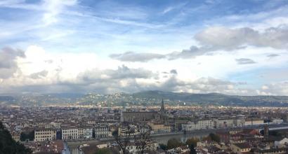
Living in Zlatoust and not visiting Taganay is like a Muscovite never taking a walk along Red Square. True, we didn’t climb the mountains, but to begin with we just took a walk below, to the Kamennaya River.
So, Taganay National Park is a huge territory that includes forests, mountains, rivers and swamps. Lovers of hiking and spending the night in tents come here from all over the country to spend a few days at special sites - shelters, and these places also attract ufologists and other lovers of all kinds of anomalies. However, it is also great for family walks on a sunny day off.
At the entrance, tourists are greeted by a banner with brief information about Taganay:
To the right of the banner is the Central Estate - a small “administrative building”, which is also a ticket office and souvenir shop. First of all, let's go there.

Before you go to the park itself, you must pay for entry and register. Entrance fees to Taganay have been introduced, if I’m not mistaken, since February of this year. For residents of Zlatoust and the surrounding area it is symbolic - 10 rubles, for everyone else - 100 rubles per person. It is necessary to register so that park workers and foresters know how many people went to the mountains and how many returned. Don’t forget to visit them again on the way back and register your exit (although I’m not sure that if you don’t do this, everyone will just run in search).
Well, now that all the formalities have been settled, you can go. We have to walk about 5-6 kilometers.
The first kilometer resembles any city park. This is the main path, quite wide and well-trodden:

There are often markings on trees here. Some indicate the distance from the Central Estate:

Others are understandable only to the most knowledgeable:

Near one of the anthills there is a sign like this:


And on the trees there are feeders with reminders:


Here the trail splits into “Upper” and “Lower”. Since we are going to the Stone River, we need the Lower Trail, which is also called the Old Kialim Road. And here is the first stream:

There are several of them here, and you can all cross them over wooden bridges. The streams themselves are small and shallow, but their bottom and banks are covered with viscous mud, in which your foot will instantly sink.

But this is a more serious obstacle - the Bolshaya Tesma River, we also cross it via a bridge:

The new sign offers a choice between the White Key and Taganay shelters. Let's go to the White Key:

A little more and finally a sign to the Big Stone River:

So you walk and walk along the path and suddenly you begin to notice that on the left side, instead of a forest, suddenly there is something white behind the trees:

Here it is, finally - the Great Stone River:

Huge stones weighing up to 10 tons lie flat, like a gravel road, or a river flowing from the mountains. Up there, see how it “flows” down the mountain?

The length of the Stone River is approximately 6 kilometers, the width in some places reaches up to 700 meters. We were at the very beginning of the river, here it is not so wide. But still impressive.

In one place there is a path between the stones so that you can walk calmly and not climb over the stones, which is quite dangerous.

Despite the beginning of May, there is still snow between the stones covered with lichen:

If you listen closely, you can hear the murmur of water flowing under the stones. But it is very deep - the stones lie on top of each other another 4-6 meters deep.
In fact, photographs do not convey even half of this beauty, as well as the sensations that you experience when looking at an endless, even “flow” of stones.

Until now, no one can say exactly how the Stone River was formed. Some believe that it was a glacier sliding down from the mountains, others are sure that the stones slowly rolled down as a result of the destruction of the mountains due to weathering, and others even attribute volcanic activity and earthquakes here. Be that as it may, can you imagine what a roar there would be if thousands of huge stones suddenly began to roll down from the mountains, colliding with each other?
And in conclusion, I suggest watching a short video about Taganay and the Stone River, for atmosphere, so to speak :)
Big Stone River- the largest placer, located between the Bolshoi and Middle Taganay ridges and stretches from NNE to SSW for 5-6 km, reaching a width of 20 to 250 and 700 m. Numerous mountain streams are often buried under the “bed” of ancient stone streams.
Weekend tour: "Stone rivers of Taganay"
Tour program:
08.00 - Departure from Chelyabinsk.
11:30 - We arrive in the city of Zlatoust, on the border of the Taganay National Park and begin the hike to the stone rivers of Taganay;
The walking part of the route follows the “lower” path through the forest;
Search for aventurines on the Big Stone River;
Rest on an equipped clearing with information boards;
From the Bolshaya Kamennaya River there are beautiful views of the Double-Headed Hill and the Taganay forests.
On the way you can drink water from the spring, which is located next to the stone river.
18.00 - Departure to Chelyabinsk;
21.00 - Arrival in Chelyabinsk.
You need to take packed lunches, a thermos of tea, and drinking water with you.
NP Taganay
Taganay National Park is located in one of the the most unique corners Southern Urals - in the area of the Taganay mountain cluster, just north of the ancient Ural city Chrysostom. Passes through the park geographical boundary Europe and Asia.
ADMINISTRATIVE GEOGRAPHICAL POSITION AND BOUNDARIES
The territory of the Taganay National Park covers the northern part of the mid-altitude mountain ranges of the Southern Urals, which is a separate mountain unit, on three sides turning into plateaus and then into flat forest-steppe. The national park is located in the western part of the Chelyabinsk region, 130 km from regional center and is adjacent to the border between Europe and Asia. Administratively, the park territory is located within two municipalities: Zlatoust urban district and Kusinsky municipal district. The territorial center of the park is the third largest city of the Zlatoust region, through which the automobile and railway direction Chelyabinsk-Ufa-Moscow.
Dimensions of the park: from south to north - 52 km, from west to east on average 10-15 km. total area The park area is 568 km² (56.8 thousand hectares). Geographical coordinates territories: 55°08" - 55°33" N, 59°34" - 60°02" E.
The park is surrounded by four municipalities, administrative centers which are the cities of Zlatoust in the southwest
apad, Kusa - in the west, Miass - in the southeast and Karabash - in the northwest.Two roads pass through the territory: one on the south side (with a hard surface) with the Zlatoust-Miass connection, the second with the south-west (with an unpaved surface) with the Zlatoust-Magnitka-Alexandrovka connection. The density of the road and path network in the park is not high. Basically, these are traditional tourist trails laid in the mountains and intermountain valleys by many generations of travelers. The most popular of them runs along the eastern slope of the Bolshoy Taganay ridge. A network of forestry roads inherited from loggers, in most cases only accessible during the dry season and winter.
In the landscape zoning system, park races
located within the Taganay-Yamantau mid-mountain goltsy-taiga district of the Uraltau province of the South Ural region of the Novaya Zemlya-Ural mountainous country.In the scheme of forest vegetation zoning of the Urals, the territory is located in the South Ural high-mountain district of the South Ural province of mountainous southern taiga and mixed forests of the Ural mountain forest region.
Taganay
The Taganay ridge can be called one of the most picturesque corners of the Urals. A real kingdom of rocks and stone rivers, mountain streams and impenetrable taiga and mountain tundra... A mountainous country unique in its beauty, covered in many legends and tales... Some people are attracted to Taganay by its beauty pristine nature, others are looking here for the mysterious oracles of the legendary Hyperborea. The mythical Chud people store priceless treasures of rare minerals and precious stones in the depths of the Taganay mountains.
The response ridge is one of the most beautiful peaks of the Southern Urals. A huge (more than five kilometers in length) rocky ridge rises 500 meters above the surrounding taiga, like the crest of a petrified dragon.
The highest and central point of Taganay is Mount Kruglitsa. With its outlines, it really resembles the rounded crown of the head, which is sometimes crowned with a cap of clouds.
In the rocky saddle between the Otklikny ridge and Kruglitsa is located unusual monument nature – Valley of Fairy Tales. In the middle of centuries-old fir trees, bizarre stone giants rise. These are rocks - outcrops, the result of thousands of years of weathering of rocks. Indeed, as if characters from fairy tales and ancient legends had scattered throughout the valley...
Taganay... A mountainous country unique in its beauty with the greatest natural resources, interesting history and still unsolved mysteries.
It is widely famous for its beauty due to its picturesque mountain ranges.
This is a haven for tourists. Here you can admire high mountain ranges and bizarre stone outcrops, placers of kurums and an amazing stone river stretching for several kilometers, relict forests, subalpine woodlands and mountain tundras. There are also ancient mineral mines here.
Taganay National Park was created on March 5, 1991. He became the first in the Urals. The park occupies the northern part of the territory of the Zlatoust urban district and a small part of the Kusinsky district of the Chelyabinsk region. Its area is 56.8 thousand hectares.
Let's talk about its most interesting attractions.
Big Stone River
You can get to Taganay along the upper and lower paths. The lower trail runs along the Big Stone River, a huge scattering of stones. Its length reaches 5-6 kilometers, width from 20 to 700 meters, and its area is about 90 hectares. There are more than 2.5 million blocks of stone lying on the surface alone.
Double-headed hill
This is the most southern peak ridge Bolshoy Taganay and the first Mountain peak, which is encountered on the way of tourists approximately 7 kilometers from the start of the path. A metal staircase goes up, then turns into a regular path. The two-headed hill is the most visited peak of Taganay. There are always a lot of tourists here, all year round. In winter, after a long, tiring climb, tourists quickly and cheerfully slide down to their fifth point. But at the same time, you need to remember about precautions: there have been accidents when colliding with trees and stones.
The double-headed hill is divided into two peaks: (1034 m) and Ram's foreheads(1041 m). The path leads to the first of them. At the top of the Feathers you can see the remains of a metal tower that once stood here. This was the first television repeater of Zlatoust, installed in 1958. He received the signal all the way from Sverdlovsk. However, he did not work for long - until 1961.

On one side the city of Zlatoust is visible, on the other - beautiful view on the Ram's Foreheads and the grandiose wall of the Response Stone appearing behind them.
The southern slope of the mountain is called Climbing wall. As you might guess, climbers love to train here.
At the foot of the Double-Headed Hill a spring flows - White key. It got its name from the white quartzite that covers the bottom. This is the most famous water source of Taganay. Its water is clear and tasty. The softness is even higher than that of melted snow. The water is very cold, even in summer its temperature does not exceed 3-4 degrees. In the past, the White Key was revered as a holy spring; a wooden cross stood near it.
Nowadays, the White Key shelter has been created near the spring. To the north of the Dvuglavaya Sopka (between it and the Otklikny ridge) rise small Mitkiny rocks.


Response comb
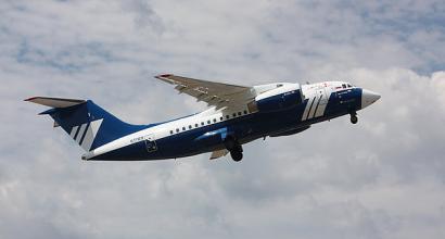
The next peak of Bolshoi Taganay (and outwardly the most spectacular) is the Responsive Ridge (1155 m). It is named for its ridge-like outline and loud, repeated echoes caused by sound bouncing off the nearly vertical rock wall. From a distance, depending on the angle of view, it resembles either a prehistoric lizard or a frozen woman in flight. sea wave, then an elongated comb. The length of the rocks is about 800 meters, the relative height from the foot is 150 meters. In the northeastern part of the Otklikny ridge there is a large tectonic fault along which underground fissure waters are discharged. There are also three ascending springs here. True, in the summer they often dry out.
On December 30, 1947, a plane flying from Chelyabinsk to Moscow crashed on the rocky wall of the Otklikny ridge. All five people on board died. The body of one of them, found only a few months later, was buried there. Even today, you can still find the wreckage of this plane between the stones.

Mount Kruglitsa
The trail from the Otklikny ridge to the next peak of the Bolshoy Taganay ridge - Kruglitse - passes through the so-called Valley of Fairy Tales. This place is a section of sub-alpine low-growing coniferous forest, surrounded by bizarre remains of sugar-like quartzites. Many remains have their own names, depending on who or what they resemble. The rocks that make up this section of the mountains easily crumble under the feet of tourists and the paths here are covered with coarse-grained quartz sand. They say that when walking on quartz under your feet, a piezoelectric effect sometimes occurs in this place and sparks can be seen in the dark.

Mount Kruglitsa (1178 m) – highest point of all Taganay mountain range, which got its name for its characteristic round shape. Outwardly, its shape may resemble a volcano. The slopes of the mountain are covered with kurums. The northern part of the Kruglitsa peak is interesting, representing an ideal flat area.

Watching the peak of Kruglitsa on a clear sunny day, you can sometimes notice the curious effect of the mountain swaying, as if it were about to break away from its base. This phenomenon is explained by the streamlined shape of the peak and the close position of pressure groundwater (the foot of Kruglitsa is a continuous swamp). The sun, heating the stones, draws moisture from the cracks with its heat, the air becomes easily mobile, creating such an illusion.
Kruglitsa, like a magnet, attracts esotericists, occultists, and psychics. Various sacred signs are painted here and there on the stones. The most common is the Roerich sign. There are also many small seids made of stones. According to the beliefs of some tourists, wishes made on Kruglitsa will certainly come true.

To get to the next peak of the Bolshoy Taganay ridge - Dalniy Taganay - you need to go down and go through the Taganay tourist shelter. The climb to Dalniy Taganay is very long. Already on the way to the top you will come across a well and a sign nearby “Botanical monument Podgoltsy woodlands”.
Dalny Taganay (1146 m) is the northernmost and most extensive peak of the Bolshoy Taganay ridge. It is divided by several low but beautiful ridges. There is an excellent view of the neighboring ridges and mountains. From Zlatoust to Dalniy Taganay there are more than 20 kilometers.
Here is real tundra with its characteristic vegetation. In autumn, berries typical of the north are found. The Dalnetaganay mountain tundra is unique and is a natural monument.
At the top there are houses of the Taganay Gora weather station - the highest in the entire Urals. It was opened in 1932 and closed in 1992. Now there is a tourist shelter here. Usually there are noticeably fewer tourists here than at other shelters.

Three Brothers Rocks
Rocky outcrops of the Three Brothers rise above the forest between Kruglitsa and Dalniy Taganay. These are three high stone outcrops, up to 40-50 meters high. IN good weather they are clearly visible from Kruglitsa.
In the past, Old Believers hid in this place (as well as on Mount Itsil). In the 18th-19th centuries, Taganay forests were very popular among Old Believers. Persecuted by the authorities, adherents of the schism found refuge here. The schismatic hermitages were built underground, skillfully camouflaged from the outside with granite blocks, moss, and uprooted tree roots. It was almost impossible for the uninitiated to find them. In addition, the hermits were very careful in their contacts with the world.
Among them were people who were considered saints. Thus, in the 50s of the 19th century, Elder Zosima, who enjoyed incredible popularity, died, to whom people came from thousands of miles away for a blessing. After his death, a popular rumor spread that prayer at the elder’s grave (located somewhere on Taganay) heals diseases and works miracles. And in 1910, on Taganay, another elder Ambrose passed away into the world, whose relics were declared incorruptible by the schismatics.
Mount Jurma
Further north of Dalniy Taganay is Mount Yurma. This is the northernmost peak of the Taganay National Park, its height is 1003 meters. It is believed that it starts from here Southern Urals, and the area to the north belongs to the Middle Urals. The main attraction of Yurma is the picturesque rock of the Devil's Gate.
It is interesting that in ancient times the Bashkirs considered Yurma a holy place. It was forbidden to visit her. Translated from Bashkir, “yurma” means “don’t go.” And even today, the management of the Taganay National Park has classified the part of the mountain within the boundaries of the park as a protected area. For visiting it and spending the night here, you can be fined a tidy sum.

Small and Middle Taganay
The small ridges of Small and Middle Taganay stretch parallel to Bolshoi Taganay. Unlike the main attractions of the national park, these places are visited infrequently.
The length of Maly Taganay is about 11 kilometers, the maximum height is 1033 meters. The slopes of the mountain are covered with kurums, and there are rocky outcrops.
Middle Taganay is the shortest ridge of the Taganay mountain cluster system. Its length is 2.5 kilometers. The height reaches 959 meters.

If you drive along the road to Magnitka beyond the entrance to national park, then you can get to the Black Rock. Rocky outcrops rise here, from which a beautiful panorama of the Bolshoi Taganay mountain range opens. The height is 853 meters, belongs to the Nazminsky ridge. In the summer, the Black Rock art song festival takes place here. Dedicated to the Black Rock.

Akhmatovskaya mine
In the past, several mines and mineral mines operated on Taganay. The most famous mineral of Taganay is aventurine. This is a type of quartzite, which is a valuable ornamental stone. Taganay aventurine even got its own name - taganaite. In the Hermitage you can see a vase made from Taganai aventurine.
Perhaps the most famous mineral mine of Taganay is Akhmatovskaya. It is located near the road to Magnitka and has been known since 1811. It consists of two large workings and a series of small pits. There are just some minerals that are not found here!..

Zlatoust city
The path to Taganay begins from the city of Zlatoust - the birthplace of damask steel and unique engravings on steel. Dedicated to this South Ural city. If you have time, you can get acquainted with its sights, look into a good local history museum, climb the bell tower on Krasnaya Gorka and admire the mountain park named after. P.P. Bazhova. The city is surrounded picturesque mountains. This gives it charm, although the city itself, it must be admitted, is very neglected by the city authorities.

How to get to Taganay?
Taganay National Park is located northeast of the city of Zlatoust in the Chelyabinsk region.
By car from Chelyabinsk or Ufa you need to take the M5 highway, then turn to Zlatoust. From Yekaterinburg you need to drive along the Chelyabinsk highway, then turn onto Kasli. At the beginning of the city of Miass, turn right - towards Zlatoust. The map below will help you navigate. You can leave your car in the parking lot near the entrance to the national park. Here you can also visit the Museum of Nature.
There are also buses and trains going to Zlatoust, and also electric trains from Chelyabinsk.
Entrance to the park requires a passport and a fee. You will even have to pay for overnight accommodation with your own tent. There are several shelters with houses in the park; you need to reserve places in advance.
It is better to go to Taganay for at least 4-5 days. This is enough to get around its main peaks. A visit is possible at any time of the year, but it is worth considering that weather in the mountains it is always noticeably tougher. Happy travels!
Taganay National Park is a group of mountain ranges in the Southern Urals. Its length is 25 km, and its height rises to 1178 m. Here, between the ridges of the Bolshoi and Middle Taganay, there is the Big Stone River - an amazing and impressive natural formation, a real miracle of nature.
In fact, this is a natural wonder - a uniform conglomeration of huge rocky boulders that stretches for hundreds of meters and looks very much like a river. The large stone river Taganay stretches from northeast to southwest for about 6 km. The width of the river reaches from 20 to 270 m. On average, the size of the boulders is 3-4 cubic meters in volume, but there are much larger specimens - up to 30 meters and 9-10 tons of weight. According to rough calculations, we can say that about 300 blocks are located on 100 square meters. They lie at least 4.6 m deep, forming 3-4 layers.

Stone River is composed primarily of aventurine, a type of quartzite. Aventurine clumps vary in color and lichen patterns on them. There is no longer any vegetation on the stones except lichens. Nothing can grow through a stone conglomeration. The only exceptions are rare pines over a hundred years old. Numerous mountain streams often bury themselves under the “river bed” of ancient cliffs. Such a landmark would definitely not be lost in the list of 7 wonders of Russia.

Many people mistakenly call the Kamennaya River “kurumnik”. Although Kurum (ancient Turkic kamrums are stone rivers, stone streams) even today continues to slowly slide down. But this unusual river is now almost motionless, because the slope does not exceed 2.5 degrees. This unique field is a national treasure. Something similar can only be found in India, and nowhere else in the world. The origin of such stone rivers has not been fully studied, but there are versions that the Great Stone River Taganay was formed by a glacier during its descent from the Taganay Mountains.

Local residents say that winter is the most wonderful time in Taganay, and the river itself is the pearl of the National Park. They invite all tourism lovers to visit this miracle of nature. The air here is extremely clean, and only birdsong, wind, sun, the smell of fir trees and rain disturb the perfect silence.
Report
Big stone river in winter

Last week I added some fuel to the heated debate about which is cooler - Nikon or Canon. Together with the film crew of the “My Planet” TV channel, I participated in the filming of a film about how I take photographs with Nikon. For this we went to Chelyabinsk region. Before a new round of holivar begins, I want to talk about Taganay - the place where our filming took place.
Taganay is a national park in the northern part of the mountain ranges of the Southern Urals. I was there for the first time last summer as part of the “Russia” expedition. I was greatly impressed by the pearl of the park - the Big Stone River. This is a uniform pile of huge rocky debris that stretches for hundreds of meters and looks very similar to a river. A formation of similar size and beauty of stones is known only in India and nowhere else on the globe.
Local residents said that the most beautiful time in Taganay is winter, so as soon as I had a free week, I agreed with My Planet and took a ticket to Chelyabinsk. More details about everything under the cut...

Report
My peak is on Taganay
Traveling is always a way to look at yourself from the outside. Perhaps they exist not so much in order to get to know foreign countries, but in order to look at themselves and their lives with different eyes. Traveling outside cities and civilizations, moreover, very well reboots and gives new strength.
The other day I took another step towards myself on a trip to the Southern Urals, to the Taganay National Park as part of a large IzhSplav team. There were more than 50 of us, the youngest participant was only five years old!

Report
Dalny Taganay in July
At the beginning of July we decided to go for three days and two nights to the Meto Station in Taganay and back. In the national This is not my first time visiting Taganay Park, but nevertheless, I have not been everywhere yet. During these 3 days we visited Kruglitsa, Itsyl and distant stops along the route, and walked along the lower path.

Report
Single bicycle trip through the Middle and Southern Urals. 2009

The summer of 2009 turned out to be extremely boring, full of monotony and despondency. I missed new vivid impressions, emotional explosion and adrenaline in my blood. When the lack of all this, combined with incessant depression, reached its apogee, I finally decided to go on a solo bike trip through the Middle and Southern Urals. I thought that I would not soon decide to go alone in our inadequate country, because it is quite dangerous, but circumstances made their own adjustments. It’s a pity that there were no volunteers, because in a group it’s both more fun and safer.
Report
Winter Taganay
Summer Taganay, of course, is very different from winter. If in winter it’s beautiful even downstairs, then in summer you definitely need to go upstairs. At the end of November we decided to explore Taganay again and found ourselves in a winter fairy tale.