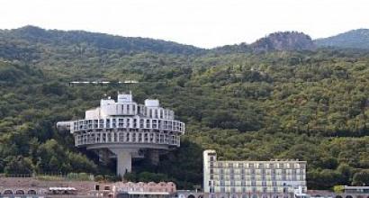
The command center of the Strategic Missile Forces "Kosvinsky stone. Mountain massif Konzhakovsky Stone
Kosvinsky Stone- a mountain range located next to the Konzhakovsky stone, in the Northern Urals. It is composed mainly of pyroxenites and dunites. In the lower part, the slopes are covered with coniferous forests, and above - with mountain tundra and stone placers. Height - 1519 meters.
Details about the top-secret Soviet system located in this mountain were first revealed in 1993 by Bruce G. Blair, a former American observer of ICBM launches and now one of the leading US experts on Russian weapons. Fearing that a covert attack from an American submarine could wipe Moscow off the face of the earth for 13 minutes, the Soviet leaders ordered creation of an automated communication network, strengthened so that it was able to withstand the effects of a nuclear strike. The system was controlled by a computer similar to the one referred to in " Doctor Strangelove', codenamed ' Perimeter". The system was fully operational in January 1985 d. And it has not yet been dismantled.”
(System "Perimeter", Index URV Strategic Missile Forces - 15E601 - a complex for automatic control of a massive retaliatory nuclear strike, created in the USSR at the height of the Cold War. Designed to guarantee the launch of silo ICBMs and SLBMs in the event that, as a result of a devastating nuclear strike on the territory of the USSR, all the command units of the Strategic Missile Forces capable of issuing an order for a retaliatory strike are destroyed.
In the Western press, the system was given the name dead hand (dead hand ) .)

In the additional explanations that conclude Smith's book, one can find a link to a more detailed description of Soviet computer system "Perimeter" published in 2003 in the Washington Post by Bruce G. Blair. Today he heads the Institute for World Security in Washington, a liberal think tank.

The main targets of American Cold War strategists in Russia were facilities located under the mountains Yamantau and Kosva in the Central and Southern Urals.
They were huge construction sites deployed in the late 1970s, when all of the US nuclear power was aimed at the heart of the communist complex. Fearing an attack that could decapitate the country, the Soviet government sent tens of thousands of workers to these construction sites. Based on images taken by US spy satellites, work in these areas continued into the late 90s.
Blair received information about command bunkers under construction (drawings and notes) in the late 1990s from the senior officers of the Strategic Air Command who were responsible for pointing American missiles at Soviet targets.
According to him, the Yamantau command center is located inside a mountainous quartz massif at a depth of about 1 thousand m. It's more of a refuge for top political leadership than a command post, as Yamantau's communications systems leave a lot to be desired, as the quartz rocks prevent radio signals from getting through the mountain.
But even this “monument of the nuclear age” pales in comparison with the automated system “Perimeter”, installed in the area of Mount Kosvinsky Kamen. According to Blair, “American strategists consider it the main decoration of the crown of the Russian nuclear combat command system, since from here it is possible to communicate through the granite thickness with Russian long-range strategic aviation using VLF- radio signal (3.0 - 30.0 kHz), capable of propagating even in conditions nuclear war. This bunker is a critical link in the communication network system " doomsday machines"designed to provide semi-automatic retaliation in response to a decapitation blow."
However, for the final launch of the rockets, the Soviet system needed a person who would press the button. “This“ doomsday machine ”, which has earned in 1984 year, during the apogee of the era of nuclear confrontation, was a stunning crowning achievement of engineering creativity,” writes Blair. According to him, if the systems " Perimeter"registered a nuclear strike on the territory of Russia, and then did not receive any commands from Moscow or other command bunkers, then only one person who was deep in the mountain massif received the authority to launch the entire nuclear arsenal Kosvinsky Stone.
Blair believes that the Bush administration's interest in bombs that destroy underground bunkers is due to the desire to obtain a device that can eliminate " death machine", buried in the depths of the Kosvinsky bunker. If this statement is true, then the Soviet system has retained its functionality. Perhaps someone knew about the deactivation of the Perimeter, but Blair could not find such information.
President Bush's nuclear war directive requires the Pentagon to develop plans to destroy Yamantau and Kosvinsky Stone along with 2,000 other targets in Russia and 100 in China. But such a strategy requires highly effective weapons that are far more destructive than the bombs dropped on Japan in 1945. This is a doomsday plan in which two underground bunkers are to be destroyed in a nuclear exchange.

What concerns Blair today is not the prospect of a targeted nuclear war in the spirit of the concepts of " cold”, and the so-called random war caused by the presence in the arsenals of states of the too easily triggered and unreliable weapons of the previous era.
Colleagues consider Blair a cautious scientist who raises only real questions. For example, Steven M. Meyer, an MIT expert on Russian weapons, told the Times that Blair " demands much higher standards of himself in the process of gathering evidence than others in the intelligence community ».

His book " The logic of an accidental nuclear war”, as well as disturbing publications - another reminder that the illogicality, irrationality and possibility of catastrophic errors on the part of our nuclear command and control systems inherited from the Cold War era have never been corrected or corrected by anyone. They were simply forgotten as soon as the Cold War ended. Judging by his analysis, in those days we managed to avoid a full-scale nuclear conflict only due to chance, not reason.
Nowadays
The initial impetus for the construction of the facility, which did not stop even during the years of the crisis of the 90s, was the exhausted horizontal platinum mines, which in themselves were a rather secret mine during their development. Mount Kosva, by the way, is made of dunites, which are a mineral for the production of refractory materials, and also have another useful property - blocking scanning radio emission (isn't it a very valuable property for the military. To supply the object a couple of years ago, an additional Power transmission line, a new bridge has been built across the Kakva River, the dirt road is maintained in good condition all year round.Tractors with heavy construction equipment and cement trucks regularly move along the road between the city of Karpinsk and the village of Kytlym.In the city of Karpinsk, a residential building was built specifically for officers and their families guarding serving the facility .... In Kytlym itself, adjacent to the base, residential houses for soldiers and officers, and other infrastructure are being built.
All they know locals, this is that the whole mountain is dug up like an "anthill". And those who were there when the facility was under construction say that heavy vehicles move freely through the tunnels, there is a multi-level pass system, and construction units work in isolation from each other and no one really knows what is being built and why.
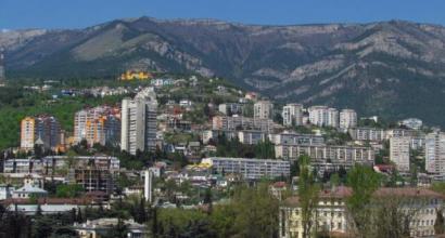
In June 2011 we went to main mountain and main ridge Sverdlovsk region - Konzhakovsky stone. Konzhak is a favorite place for climbing for many tourists both from Yekaterinburg and from all over Russia. Especially appreciated, of course, by residents of the Sverdlovsk region and neighboring districts. After all, not all regions of our vast Motherland are lucky with such a relief! I agree, Konzhak is not the Himalayas at all, but this fact does not lower this mountain at all!
Mount Konzhakovsky stone attracted me for a very long time, just like that on the border of Bashkiria and the Chelyabinsk region. I tried once already to climb Konzhak, but I failed to reach the top. It happened in 2010, in the month of November. Then the Konzhakovsky stone met us with knee-deep snowdrifts. We got somewhere up to 17-18 km of the marathon route and did not go further. At this altitude, there is not much snow and it is rather ice, ice crust on the kurumnik. There was a terrible blizzard, visibility - 50 meters from the force, it is almost impossible to look against the wind with unprotected eyes, ice crystals hurt the eyes. The time was already in the evening, and we did not dare to go further, we were afraid that it might get dark and we would not be able to get back in such a blizzard. Despite the fact that milestones are stuck along the marathon route, but often they are not even visible, you have to look and go as if at random.

But this time it was June, and no snow blizzards are expected here. So the ascent should not be broken. Tolyan and I arrived in the hero city of Karpinsk by bus. Since buses in the direction of the village of Kytlym rarely go, then, of course, we did not have time to go to it and we had to take a taxi directly from the bus station. Having learned that it was necessary to go in the direction of Kytlym, the driver changed to another car, to a Zhiguli. Since the road will be unpaved for about 50 km and he did not want to spoil a better car over these bumps. But it doesn't matter, Zhiguli, so Zhiguli.

We sat down, drove with him to the turn to Konzhak, not reaching about 5 km to the village of Kytlym. Quite a cheerful and interesting driver, we had a great talk with him about these places, nature, hunting, fishing. He told us that sometimes you go to Kytlym, and beavers cross the road - you stop and let them through. The first few kilometers of the marathon were just terribly attacked. It was already evening, we reached the parking lot on the banks of the mountain river Konzhakovka and decided to spend the night here.


The river Konzhakovka runs straight from the snowfields of the Konzhakovsky stone. Crystal clear and delicious water. Ideal for cooking, brewing coniferous tea, washing and other sanitary and hygienic needs.

Cheerful stump - the keeper of the parking lot near the river

It was simply impossible to sleep at night. Got the mosquitoes. Our tent was already old and the zipper did not close, so we had to sleep with the tent open, which was very helpful for mosquitoes. Having had a bad night's sleep, we got up in the morning, prepared a meal and set off on our way.


We got to the famous "Glade of Artists", met guys from the Chelyabinsk region there, talked a little, and had a rest. And then decided to go further to the top. Of course, it is unreasonable to go to the top with heavy backpacks, so we hid them behind a large cedar. We took with us the necessary, a two-liter flask of water and went on. The weather was cloudy.


The forest gradually changed and a "park crooked forest" was already appearing from crooked birches, and small Christmas trees, and elfin cedar


But the old Konzhakovsky stone showed us his snowfields. Those that give water to numerous streams, which in turn flow into rivers. The beginning of the mountain tundra.


Then we came to an almost straight section with alpine meadows.


Then boulders, kurums already went.


The case was nearing its peak.


And finally, the long-awaited peak! We did it!

As we began to descend, the clouds dissipated a little. Here they could not before, when we were at the top, to enjoy the 360-degree view! Here we also got two two-pound weights under our arm. Just think, there is nothing strange - to meet two weights on the top of a mountain at 1569 meters. It's like this all the time.)


Under their feet they saw a dwarf birch.


The crooked forest began to appear again.


We went down to the Glade of Artists, took our things, set up a tent and started preparing dinner (or lunch). The weather played out in earnest: if we had gone to the top a little later, we would have been able to observe the panorama of the entire Konzhakovsky massif, but alas, no luck.

Here it is - the Konzhakovsky stone. Thank you for your attention!
One of the highest peaks Ural mountains and the highest point of the Sverdlovsk region - Konzhakovsky stone (1569 m). The conditional boundary of the Middle and Northern Urals passes along the Konzhak massif. At the same time, Konzhak is a unique peak of the Stone Belt in terms of accessibility. Firstly, due to the fact that you can get to the foot of the mountain range by car. Secondly, due to the fact that it is impossible to get lost on the way up the mountain. From the foot to the very top, a 21 km long route is marked with red flags and marks with a distance. There and back is a marathon distance. Every year in July, since 1996, the international mountain marathon "Konzhak" has been held there. It ranks first in the ranking of Russian marathons and is the largest in Russia, gathering more than a thousand participants from all over the world. So the path is trodden and Konjac is within everyone's power.
The road to Kytlym - a village at the foot of Konzhak. Ahead is the second highest mountain in the area, widely known in narrow circles Kosva.
One of the peaks on the way to Kytlym, there are many of them around the village. That's why he got this name - translated from the Mansi language Kytlym means "cauldron".
Clouds in places are trying to crawl between the peaks ...
Or just descend from Kosva
The village offers great views of the mountains. In places they are spoiled by the presence of a person. Especially if there are a lot of them, they are green and up to something.
Then Spetsstroy of Russia comes to their aid...
And the landscape takes on character traits, corresponding to the idea of green men about the beautiful.
However, let's not talk about the terrible. Having reached Kytlym, we started preparing for the conquest of Konzhak in a special car. Since it did not start in the spring, it was necessary to put a battery on it, check the candles and oil level, fill in gasoline. After that, the GAZ-66 started up)
Preparing to start.
In couple of hours. Halfway to the top.
We leave the car with the driver about 7 kilometers from the top. Further on foot. View from the glade of artists - a favorite place to stop when climbing.
Somewhere in a kilometer. On this slope, covered with a dwarf forest, we climbed.
Even higher and we are above the clouds. Visible Kosva.
Upon entering the plateau, we are met by a memorial sign dedicated to the 300th anniversary of metallurgy in the Urals.
Looking back. Yovskoe plateau. A couple of kilometers along it and uphill again. In the center you can see a line of flags denoting the marathon track.
South Yov peak ahead.
And this is North Yov. The stones on the slopes are covered with patterns of green mosses.
And again a steep climb up the hill. View towards Krasnoturinsk and Karpinsk.
At this height, passing clouds leave a snow cover on the stones. Mainly on one side...
The vegetation is also covered with snow, very beautiful, as if freezing.
Marathon flags at this height take on a completely unusual look)
Sunset overlooking Severouralsk
Sunset overlooking South Yov
Tells about the Konzhakovsky stone - the highest point in the Northern Urals and one of the highest
peaks of the entire Main Ural Range.
This mountain, 1569 meters high, is composed of intrusive rocks of the Lower-Middle-Paleozoic age - pyroxenites, gabbro and dunites.
In part, this was the reason for the beautiful photos for this short essay. Also in Soviet years geologists of the Severouralsk
metallurgical industry and as a refractory material. Today there is a need for this raw material and almost to the top
Konzhakovsky stone, on the Iovskoye plateau, a road was built to develop this deposit.
Whether it's good or bad - I can't say, but since this year it has become much easier to observe the beauty of the North Urals from a height of 1200m. Previously
it was necessary to go with a backpack up a rocky and partially forested slope for more than 20 kilometers, and now you can slowly but
confidently climb there in a car with a clearance slightly above average. What Ekaterina Vasyagina and I did in early June.
The road up goes first along the slope of the Serebryansky stone, from the middle of which opens good view to the dense taiga and surrounding mountains.
Previously, the taiga of these slopes was even thicker, until numerous tourists provoked several fires, as a result of which the surrounding
bald spots and bald spots appeared in landscapes. Cutting down forests also contributes to the thinning of forests, but for the time being, from above, from afar, these green
forests look like a real taiga.

Unfortunately, the builders of the road did not take into account the direction of sunlight during the work, and passing along the southern slope
The Serebrian stone road is in the shade all summer sunsets and sunrises, illuminated by the bright sun only during the day. However, at dusk
You can always find interesting stories even when you are in a disadvantageous position.
On one of the meanders of the road there is another rock overgrown with pines, which offers views of the valley of the Lobva River and another
famous peak - Kosvinsky stone, a little less than Konzhak - 1519 m. This mountain is famous for the fact that in its depths there is one
from the main headquarters of the Strategic Missile Forces - the Perimeter system, which provides an automatic retaliatory strike in the event of a missile attack. For this, in
during the Cold War, a large and deep adit was built in Kosvinsky stone. The choice of this mountain was due to its
strategic location both in the Urals itself and relative to the Russian borders, as well as the rocks that make it up,
represented by the same dunites and pyroxenites.

South of the Serebryansky stone, on the other side of the Lobva, you can see several more snow-capped peaks - Kazansky stone (1200 m) and
Seven people (1035 m). Previously, the Kazan stone was called Sukhogorsky, after the name of the nearby Sukhogorsky mine,
named in turn because of the "dry mountain", which probably meant "dry" loaches - kurumniks on the tops of mountains that do not have
trees and only tundra vegetation is observed. As well as on Konzhak and Serebryanka, the taiga rises up the slope only

Despite the altitude still far below a thousand meters and the air temperature much higher than plus ten degrees, there were still
there was quite a lot of snow, and the gnarled birch trees turned green so far only with swollen buds. It was so nice and unusual to plunge again from summer into
spring. And anticipating an even greater climate change in the next couple of hours, with the advent of darkness, we continued to climb until
found a wide flat area along the road, where it was decided to arrange an overnight stay. We spend the night as usual in the car - there we have
an equipped sleeping place that allows two photographers to live comfortably for an unlimited time. Maybe a little more comfortable
to sleep in a tent, which we took with us, but the tundra champing spring streams and stony placers discouraged all desire
camp outside the car.

The next morning we set off for reconnaissance to the purpose of our trip - to the Iovskoye plateau. Being at an altitude of 1120-1150 m, it represents
a saddle between two gentle peaks - North and South Job. Of the vegetation, only tundra grass, but rare
low bushes of dwarf pine. The grass was still brown in color, as the soil still frozen from winter was still preserved under it in places.
By the way, it is from the Konzhakovsko-Serebryansky massif, according to the maps, that permafrost rocks begin, or, as in common parlance,
eternal Frost. And approximately the same as on this plateau, the landscape can be observed in the territories much to the north, in Chukotka and in Northern
Yakutia, where I have been able to visit many times.

To the east, the Iovskoe plateau abruptly breaks down, forming the Iovskiy abyss. From this place originates the river Poludnevaya, which flows into the river. Job and
then to Lobva. Along the edge of the Iovskiy dip, there is a glacial cirque, consisting of three steep ravines, inside which lie deep
snowfields that do not melt until autumn. In the upper part of the largest of them, one can see a transverse crack, which from year to year
formed in almost the same place. Even on satellite images on the Internet you can see it, but we can’t explore it closer
took a chance - the snowfield is quite loose and there is every chance to fall into it entirely, given that its depth at the very beginning of summer is clearly
exceeds human height.

In the upper part of the snowfield, the same dunites that are planned to be mined were fan-shaped. physical weathering in
in general and permafrost processes in particular destroy and redeploy the original rock, turning it on the surface into kurumnik and
sheared boulders, which over time slowly but surely slide to the foot of the mountains.

On almost the entire plateau, turbulent and muddy, but shallow streams and streams flowed underfoot. Konzhak itself, the top of which was located behind in
2.5 km, was still almost completely covered with snow, and access to its summit was very difficult. You can climb it or when else
it is cold and there is a lot of dense snow, or when snowfields remain only in hollows, and in spring it is loose snow, under which invisible
and rather sharp boulders.

Those who learned about good road bikers on enduriks and quadrics. But
the builders were somehow very indifferently tuned, and they let everyone past their equipment without any questions. Ride on the plateau
indeed, it was possible to quickly, but it was only possible to walk slowly and carefully, and the reason for this was not the tundra swollen from the water, but drilling
pipes and iron cables left here by geologists during exploration work in the middle of the 20th century.

Under the peak of South Job (top left), the construction of a new road on the plateau is taking place, and a small hill is a little to the right
center, under the clouds, this is a dump at the end of the road. We have already built the main part of this "transport artery", and calm days before the start
very little quarrying remains.

They used to search here for silver, and copper, and even platinum. Perhaps that is why the Serebryansky stone got its name.
The Konzhakovsky stone was so named after the name of the local Vogul, Konzhakov, who a couple of centuries ago had a yurt at the foot of this mountain and
Used to hunt here.

On the slopes of the Konzhakovsky stone in the first half of the 18th century there were as many as four copper mines that sent their raw materials to
processing at the Lyalinsky copper smelter. Now there are practically no traces of these mines, but on the slope of the Serebryansky stone I
gabbro with the so-called copper green was repeatedly discovered, which is a direct ore for copper. Its narrow crest
visible at the top center of the frame.

They searched for platinum in these mountains about two hundred years ago, and even wanted to mine it, until they invited the famous Swiss
a geologist named Duparc from the University of Geneva. For about a year he was engaged in research on the plateau and eventually made a conclusion about
inexpediency of mining platinum in this place. However, attempts to find conditioned platinum are still ongoing at Kosvinsky

The snowfield of the Iovskiy Gap at first seems to be the source of the Poludnevaya River, but in June many
nameless streams that muffledly roar hidden under many meters of snow.

Between rare large boulders on the plateau, sometimes there is an elfin, or dwarf pine, which here is more like a shrub. in winter
very strong winds blow here, several meters of snow fall, but frosts can be with a huge minus, so you can grow here
only not higher than the stone behind which he managed to hide.

After enjoying the magnificent views from the Iovskoye plateau, we slowly set off on our way back. Passing on the way to Serebryanka Southern Job,
we stopped to take pictures of the mountain tundra spread out before us and the Kosvinsky stone in the background.

Despite the height of just over a thousand meters, some larches still manage to grow here. It's hard for them here, so part of
them, akin to pines, turns into a shrub variety, leaving just a few tops, lonely branches just above the main thickets
which stretch in the direction of the winds blowing here.

In the meantime, the sun was leaning towards the horizon, along which a small cloud hung. She lowered the contrast of the evening light, but
red-orange colors scattered in this haze and spread along almost the entire horizon, coloring the rare snowfields of the Serebryansky stone
in soft sunset colors.

Some larch trees that have grown too high by local standards die from the harsh climate, and the setting sun will now be many
years to paint their bare branches with the last rays against the backdrop of Mount Trapeze, already descending into twilight.

Having moved on the road to the northeastern slope of the Trapeze, we could not resist taking a selfie of our silver pepelats. Quite amazing
imagine how deep the snowfield had to be cleared here in winter by people, even if in June its apparent height exceeds five meters.
From such a wall of snow, even on a fairly warm evening, coolness and humidity blew, and streams flowed everywhere under the wheels. In spite of
all the attractiveness of such an object, it was a little uncomfortable to stand under it, and we moved on.

Having descended to the southwestern slope of the Serebryansky stone, we found the previously noted rock against the background of the eastern one turning pink after sunset.
sky. An amazing silence suddenly covered his head, there was a calm, and in cool air only overflows of the Ural jays were heard.
The forest-tundra had already begun here, larches and pines still rarely appeared, but they were already quite high, apparently on this slope
the winds in winter were no longer so violent. In the distance, to the left and a little further than the Gvardeets mountain, the city of Kytlym appeared, on the 40th kilometer of the road to
who needs to turn right to get to these places. You can also get your bearings by finding the first turn to the right after
a small bridge across the Serebryanka 2nd river.

Having arranged another lodging for the night in a wide "pocket" along the road, we decided instead of shooting the dawn at a notoriously unfavorable position
sleep, and during the day make several exploration tracks. The forest-tundra of the Serebryansky stone turned out to be much richer in
vegetation and subjects for photography than the Iovskoe plateau. Although comparing these two completely different objects is not entirely correct. After all
At each site we met, we came across something interesting and beautiful in its own way. The southwestern slope of the Serebryansky stone abounded
rocks of various sizes and shapes sticking out on the slope, and in the background a panorama of the Trapeze and the
Sharp Kosva and Tylaysky stone.

For two decades, on approximately these slopes, in July, the annual mountain skyrunning marathon "Konzhak" has been held, the participants of which
must run from the foot of the Konzhakovsky stone to its top 42 kilometers with an excess of more than 1200 meters. After the appearance
parallel to the marathon track highway, the safety of the race should be improved. But how will the road itself and future mountain
work on this natural corner - time will tell.

The accessibility to such beauties, at first glance, should cause positive emotions - all those who, for whatever reason, do not
could previously reach the mountain tundra of the Northern Urals, now they have received such an opportunity. But what will even a small mountain mountain do with nature?
enterprise, I know firsthand. After all, it is not difficult to break fragile biocenoses, and it takes decades and decades to restore them.
centuries. Especially in such a vulnerable North.

Going down to the camp after daytime walk, we started our car, which had been standing there all night, and, turning on the air conditioner, went to