Tourist routes. Climbing Elbrus in a week Climbing Elbrus 105 picket
I just recently returned from Elbrus and while my impressions are not forgotten, I decided to present them in a series of posts. Our trip coincided with the Adidas Elbrus world race 2017 competition, which added interest.
We arrived in Terskol late in the evening, walking heavy rain. We settled into a cozy campsite on the outskirts of the city at a very affordable price, only 200 rubles per person per day. The campsite had all the basic amenities: electricity, gas and even a hot shower!
In the morning the weather improved, I crawled out of the tent, turned my head and saw this landscape:
Mount Itkolbashi (3531 m). Quite a pleasant view after the boring flat Petersburg. 
Let me immediately make a small clarification: we did not set ourselves the goal of climbing to the top of Elbrus, it was more interesting for us to chat about different routes, explore the locations and evaluate your endurance.
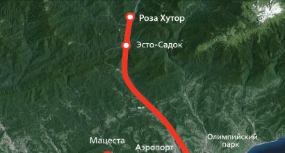
The largest number of people who want to climb Elbrus come to Cheget-Terskol-Azau, because there is infrastructure, lifts and hotels. It is the ascent from the south that is the least difficult. Many acclimatization routes start from here from 2000 to 3500 m. Usually, in the first two days people go to the waterfall Girlish braids or to the top station of the ski lift to Mount Cheget. We decided to start with the waterfall; the track will be at the end of the post.
The ascent begins from abandoned cowsheds approximately in the middle of Terskol. At first the road looks like this: 
The climb starts at about 2200 m and goes smoothly. Poles reduce the load on your legs, which is a useful thing in the mountains. 
I turned out to be the most cheerful and went far ahead. I stopped to contemplate the expanses. 
Weeeeeee we're in the mountains! Below is the Baksan gorge in which the same Cheget-Terskol-Azau are located. 
View of Cheget 
The man asked to take a couple of pictures with him on his Mark III, I didn’t refuse. 
It was Sunday. In July-August there is the largest concentration of people wanting to conquer Elbrus, plus runners came to the Adidas Elbrus world race 2017. 
The trees ended and rocks appeared.
View of the Azau clearing, the serpentine goes to the Mir Station. 
These two rocks are called the Wolf Gate. 
The landscape, like the weather, changes rapidly. 
Halt, I’ll experience Zen. A Niva 4x4 drove along the path behind us. 
The altitude has risen to 2700 m, a lack of oxygen begins to be felt, and walking becomes more difficult. 
Reached the waterfall. 
Water flows from a glacier. 
On the left is the path to the waterfall. 
I didn’t want to stop for a long time at the waterfall, so I encouraged my friends to continue climbing. 
Not far from picket 95 we stopped for lunch. Only half of the group agreed to go further. Some people got headaches and the first symptoms of the miner began. This often happens on acclimatization trips.
Along the way we meet many people, including groups with guides. Everyone says hello to mountain trails This is how it is done all over the world.
Place behind the observatory. The peaks of Elbrus are hidden behind the clouds. 
Observatory, height 3150 m 
After the observatory I continued walking alone.
View of the side of the Terskol River, the snowfields began to be clearly visible. 
I meet another group on the way, this time from Hungary.
Evening begins, you have to cut the path and speed up in order to quickly begin the descent and have time to return before dark. 
Picket 105, from the name you can understand that this is a 10.5 km trail from Terskol to the Ice Base. Tourists sometimes spend the night in this high-altitude desert. 
The building was used by the builders of Shelter 11, which burned down in 1998. 
I have never seen snow at the end of July before. 
View of the path to the observatory. 
The trail continues to the Ice Base, from there you can walk along the glacier to the new Shelter 11; walking along the glacier without equipment is not recommended. 
He raised his bar a little in terms of peaks; last year the maximum height was reached at Pico del Veleta (3396) in Andalusia. 
In the distance you can see the Barrel Shelter. 
At altitudes above 3000 m there is practically no vegetation. 
During the descent, the miner felt a little overwhelmed: my head began to spin, and strange sensations appeared in my stomach. 
Looking back, the western peak of Elbrus opened up. 
Larger. 
Against the backdrop of the miner, euphoria and a surge of strength appeared. 
On the way back it was hell, the speed was lower than on the way up. There were practically no people on the way.
It gets dark in the mountains much earlier than in St. Petersburg. By 20:00 it was already dark. At dinner we shared our impressions and went to bed; the clock was only 22.
I plan to post the remaining mountain spam soon and not put it off until winter, as usually happens.
If you have questions about trekking in the Elbrus region, I will be glad to answer in the comments.
Post Views: 1,628
Elbrus is located in the side ridge of the Main Caucasus Range, has a rounded shape with a diameter of 18 km at the base and 1.2-1.5 km at an altitude of 5300 m.
Two fused volcanic cones rise higher: Western peak- 5642.7 m (the highest point in Europe) and the Eastern peak - 5621 m. The distance between the peaks is 1450 m. The bridge between the peaks - the “saddle” lies at 5376 m.
The beginning of the route to climb Elbrus passes along a pedestrian road laid in 1938. Construction materials for the Shelter of the Eleven building were delivered along it. The end of the road was called “Ice Base” (3800 m). From here, a four-kilometer sled road was laid along the ice fields of Elbrus to the construction site, building reliable bridges over ice cracks. Until commissioning cable cars this was the most popular route to the Shelter of Eleven. Now they use the Elbrus and Gara-Bashi cable cars, then a simpler and shorter pedestrian road to Shelter-11.
Climbing route to Elbrus: pos. Terskol - VDPD. Maiden's Spit - 95 picket - 105 picket - Ice base - Shelter 11 - Pastukhov rocks - saddle - peak.
The road to the abandoned "Ice Base" of Moscow State University goes along the slopes of a lava flow between the Terskol and Garabashi valleys.

From the fork in the road in the river valley. Terskol with serpentines we gain altitude in a beautiful pine forest. The road goes in a western direction. The slopes of Elbrus are visible

Above the forest, the road passes by the Maiden's Spit waterfall. Directly from the road there is an excellent view of the waterfall itself and the surrounding mountains.

From a distance it seems small, but when you get closer you can fully appreciate its size. Trails lead to the foot of the waterfall; you can go up and swim in the refreshing streams, or just sit nearby and admire the scenery.

Soon after the waterfall, the vegetation ends and endless scatterings of lava fragments and other traces of Elbrus eruptions begin.
To the left of the road there will be the remains of a building, this is the “95 picket”, from it the paths go to the left from the main road, so as not to make an extra detour, it is better to turn onto the path that starts from the ruins.

Rising higher into the mountains, the road passes by the observatory and makes a detour to the ice base.


The path that started from the “95th picket” again goes out onto the road, which serpentinely rises along the debris of the lava outcrop. On the way you will come across another almost destroyed building - “105 picket”. It was an intermediate station during the construction of Shelter 11 on the slope of Elbrus. It received this name because it is located on the 105th section of the road from Terskol (each section is 100 meters).
At this altitude, even in summer there are snow blows that have not melted since the winter and sections of the glacier covered with stones and sand on top.

Climbing higher along the road, we reach the building of the old weather station, which is located very close to the beginning of the glacier and the Ice Base. This is a metal booth with two rooms and a small kitchen. The rooms have bunks on which you can spend the night. You can climb to this place leisurely and with backpacks from Terskol in 1 day.

A few minutes' walk from the weather station are the ruins of the Ice Base. All buildings are in a dilapidated state, without windows or doors. Almost all the rooms are covered with snow, so you won’t be able to spend the night there. In general, the base makes a rather depressing impression and is depressing...


The glacier begins immediately behind the ruins. There are many cracks on the glacier, so you need to walk together. Shells or cartridges periodically melt from the glacier - the “echo of war.” Also, bodies of soldiers killed during World War II are still found in the snow and ice.
Following the glacier to the northwest, the route leads to Shelter 11.


To reach the summit, it is best to set up a camp in the area of Shelter 11 on the rough rocks left over from the lava flow.
Picket 105 is an abandoned house, a former mountaineering hut and a staging area for the construction of Shelter 11.
One of the most beautiful abandoned places I've visited. From the outside there is a large wooden house, shabby over many years of snow and winds.
The rocks were damaged by Soviet people

Tourists still stay on the second floor. At the entrance, through their efforts, a small exhibition of the culture and life of glaciological scientists was created, who, among other things, studied glaciers.

Science penetrated into the world like a steel phallus. eternal ice Elbrus.

An ancient teapot, from which grandfathers who fought may have drunk

Horrible instruments of torture

Green mug - I had one like that too. Soviet, strong. It’s better not to touch the pieces of iron, they fall.

In general, it’s beautiful. Otherwise it’s all ice and stones, it’s boring, but here it is.

Around beauty - Terskol glacier

The passes from Terskol to Irikchat are somewhere there

There is a working toilet, of course.

View from the window of picket 105

It's dark and a little littered inside, they spend the night in the attic

It's getting dark, the clouds are rising

Black and gray

I climbed the hill behind the toilet next to the house, there is a small plateau on the hill, the remains of a power line


105 picket against the backdrop of Elbrus. Behind the picket there is a moraine, along the slope of which the road continues on as a serpentine. Somewhere at the top of the moraine there is an Ice Base, which was never reached. From there there is a road along the glacier to Shelter 11.

Again the walls of machine gun nests. It is unlikely that they survived the war exactly in this form; most likely they were restored for the reconstruction of a battle or filming, but the atmosphere was preserved.

Sunset colors of the mountains

Elbrus from picket 105

Monument next to the picket

Simple and beautiful monument cavalrymen who were sent to fight with mountain special forces

Slopes of Elbrus

The comrades returned old road, I walked along the ridge towards the observatory. The ridge is quite conventional, the descent is not very steep, it’s easy to walk.

Stone sculptures, which I photographed on the rise, from the other side

And another view of the glacier...

Despite my hiking experience, I somehow didn’t take mountain hiking seriously until recently. On the water it’s easier with equipment, you can take it with a reserve, you don’t need to carry anything on yourself - everything floats on its own. On mountain rivers you don’t really need to row, just steer a little and that’s it :) Prejudice towards hiking I had some...
Last year, reading other people's enthusiastic reports about hiking in the mountains, I suddenly thought - what the hell? Maybe I'm depriving myself of something important and right? After all, you can argue about the taste of oysters only with those who have tried them.
It’s decided, I’m going to Elbrus. Why Elbrus? To amuse your emergency feelings, of course, because the most high point Europe, one of the Seven Summits. Well, small “feats” are needed in life, they stimulate further movement.
For normal people, purely technical questions begin - finding a guide, coordinating a vacation, withdrawing money from the card. We are going the other way. I am dubious of commercial trekking groups and even more dubious of guides. Although I understand perfectly well that in some cases it is impossible to do without the help of a professional. In general, the point is strangely explainable. Moreover, what’s interesting is that this very point applies absolutely equally to various kinds of instructors. The fad does not allow you to go to the mountains with a commercial group, but take lessons from a windsurfing instructor or alpine skiing- Please:)
In short, no guides! Needed a partner.
Dad, I'm going to Elbrus in June. Are you coming with me?
- You can go...
2. Next was theoretical preparation. An oblique shelf, a saddle, shelter 11 and even, what a nightmare, a corpse dump - these words excited the imagination. An acclimatization schedule gradually emerged. But I didn’t have much practical experience in mountain hiking. It was completely rotten with practice, I would say :) We both, at one time, went on a water five in the Sayan Mountains. Plus, my father went by radial to Topographers Peak, also in the Sayan Mountains. Well, plus skiing, but that’s all up to 3000 meters.
Okay, we'll figure it out on the spot. We set off towards the M4 highway, outside the window of a quarry with yellow walls. Not only careers, of course, but they too: 
3. The path along the M4 has been traveled a thousand times, everything is the same. We left late, so we spend the night somewhere near Rostov and the next day we turn onto the M29 "Caucasus" and head towards Mineral water. The first hill in the area of the turn to Pyatigorsk receives increased attention, so what can we take from the inhabitants of the plains :) 
4. We enter the CBD and turn into the Baksan Gorge. There is a constant and decent rise in altitude. Traffic cops with machine guns and in armored armor, armored personnel carriers and concrete blocks at posts, between which you need to drive in a snake. And simply unreal, unearthly beauty around. Baksan River: 
5. We didn’t book anything in advance, since we initially planned to set up a tent at a local “campsite”. But I didn’t like the camping; the plywood houses with outdoor amenities for 300 rubles a pop were somehow not impressive either. As a result, we settled into a junior suite with a shower and a refrigerator in the Cheget clearing, cutting the original price exactly in half, solely thanks to the charm and bargaining skills of my partner (well, yes, I knew who to call:) Around 6 pm we dropped our things and followed the idea of active acclimatization Let's go for a walk around: 
6. “Around” somehow naturally turned into the road to Cheget :) In general, on the first day after arrival, the ascent to Cheget was planned (there was also the option of a cable car up and legs down, so as not to burden the frail lowland organisms with an unreasonable load) , but the road made its own adjustments and we arrived at six in the evening instead of the planned middle of the day: 
7. Before dusk we manage to rise to about 2500, we get into a cloud and run down. The temples somehow “itch and itch”, I noticed a similar reaction of the body back in Dombay. And this is only 2500 meters. I’m starting to be afraid of further freakouts of the body at altitude. Yes, a photo about loneliness: 
8. The next day we plan to go out lightly to picket 105 past the Maiden Spit waterfall and the observatory. The trail is located very quickly, thanks to the GPS navigator, and goes between local farm buildings. Sounds and smells are coming from the buildings :) 
9. The walk is quite easy, you meet other tourists along the way. They are very different, but the only thing uniting them all is friendliness. An Indonesian photoblogger was dragging a huge tripod upstairs. There are five of us going, including two guides (sort of). We met in the evening below, in the Cheget clearing, and were never seen again. I hope that the Indonesian tripod, together with its stubborn owner, has reached the top: 
10. My temples no longer “itch” and I generally feel cheerful, which makes me happy. And don’t tell me that the shower the day before helped :) 
11. The weather is changing rapidly. This frame is separated from the previous one by only 40 minutes: 
12. A giant billiard pocket right in the center of the frame: 
13. We slowly reach the waterfall. It’s morning, and it’s only mid-June, the glacier is melting badly, so the hair is so-so: 
14. What can you think about when you look at a waterfall? 
15. Of course, only about how it is inside :) 
16. The clouds are quickly disappearing somewhere again, we arrange a small halt under the waterfall: 
17. Almost immediately after the waterfall, the observatory is visible. By the way, Ukrainian. Visokohirna posterezhna base: 
18. In general, the route is popular; it is quite crowded even now, when the season has not yet really begun. We meet a married couple who are going to Elbrus the next day. They were remembered for extracting a huge bunch of bananas from the depths of their backpack, for which they instantly received the nickname “bananas.” From the conversation it clearly follows that the guys are completely new to tourism. We haven’t seen any more “banana” ones: 
19. After talking with our fellow travelers, we feel a little more cheerful, because when we were coming here, we assumed that every second one was a “Snow Leopard”, and every tenth one had a “Crown of the Earth” on his head. And between them are “mutants” running to the top from Azau in 3 hours and 4 minutes: 
20. The observatory remains below, there is 105 picket ahead. The road is blocked in places by snowfields. The snow is wet, it’s not very easy to walk. We cut as best we can: 
21. I come across a monument to the cavalrymen who fought here with the Edelweiss division. From August 21, 1942 to February 13, 1943, there were German flags on both peaks of Elbrus. And I have a suspicion that some of the dilapidated stone walls nearby are directly related to those times: 
22. They didn’t go down to the building, sipped some soup and set off on the way back. The serpentine road to the ice base is visible. Terskol-105 picket-ice base-shelter 11 - classic southern route to Elbrus before the advent of cable cars and other snowcats: 
23. We meet Chelyabinsk residents, they are also going to Elbrus. The words “Chelyabinsk guys are so harsh...” are interrupted by exclamations of “We know! Enough…". This is what it means to become an Internet meme :) 
24. It’s cold and purple clouds are moving around without a break: 
25. Suddenly, for a very short time, our goal for the next few days becomes visible. A sign, no less: 
26. We walked about 24 kilometers during the day (measured with a ruler in Google Earth). The climb was about 1200 meters. Going down turned out to be harder than going up :) 
27. That's it. To be continued… 
P.S. Should we leave the photo 1000 on the long side?
Elbrus. No guides
Tourist routes
Along the path of the builders of the “Shelter of Eleven”
 (Terskol village - “New Horizon” - “105th picket” - “Ice base” - Terskol village. Length - 26 km, duration - 3 days.)
The route follows a pedestrian road built in 1938. It was used to deliver construction materials for the Shelter of Eleven building. The end of the road was called the “Ice Base” (3,800 m). From here, a four-kilometer sled road was laid along the ice fields of Elbrus to the construction site, building reliable bridges over ice cracks. Until the launch of the EKD, this was the most popular route to the Shelter of Eleven. Now they use a simpler and shorter pedestrian road from the Mir station.
The beginning of the hike coincides with route No. 2. It is best to spend the night at the New Horizon shelter (2900 m) or in tents near it to admire the evening panorama of the mountains. In the pink rays of the sunset, the peaks of the Main Caucasus Range are especially spectacular in the lateral (western) lighting. If, moreover, the Baksan Valley is filled with clouds, then you get a unique feeling as if you are on the steep shore of a gray foaming sea.
They set out on the route in the morning. They rise to the crest of the spur and move along it towards Elbrus. An hour later, tourists approach a small depression on the ridge on which the weather station houses are located. This is the “105th picket” (3300 m). It is located on the 105th 100-meter section of the road from Terskol.
On the approach to the weather station, to the right of the road, there is a monument to the cavalrymen of the 214th regiment, who defended the approaches to Elbrus during the Great Patriotic War. On the wide rocky ridge, firing points and the remains of fortifications and dugouts were preserved. Military operations here took place from mid-August to early November 1942. The first to bear the blow of the mountain rangers of the Edelweiss division, rushing from the slopes of Elbrus to the Baksan Valley, were the cavalrymen of the 214th regiment. By the end of September they were replaced by soldiers of the 897th Infantry Regiment. The heroic events of that time are described in detail in the book by O. L. Opryshko “The Cloudy Front of the Elbrus Region.”
Above the “105th picket” the trail is littered with rocks in places and covered with landslides, but it is not difficult to walk along it. From it you can clearly see the valley of the Terskol River and the glacier of the same name, riddled with cracks, hanging above the valley, as well as the south-eastern spur of Elbrus with the dominant peak Terskolak (3787m). Tourists climb to the top of an ancient lava flow. Both peaks of Elbrus and the Garabashi glacier are clearly visible. A 3-hour journey from the “New Horizon” leads to the “Ice Base” - a flat moraine area near the upper reaches of the Terskol glacier. Here there is a small house of a tourist shelter and the buildings of the Ice Base scientific station. The Shelter of Eleven is clearly visible. It's 1.5 hours away, but you can't go there without special equipment and skills, walking on closed glaciers is dangerous. In addition, this requires permission from the Elbrus KSS.